FAA INFORMATION EFFECTIVE 11 JUNE 2026
Location
| FAA Identifier: | CNK |
| Lat/Long: | 39-32-59.5240N 097-39-07.3460W
39-32.992067N 097-39.122433W
39.5498678,-97.6520406
(estimated) |
| Elevation: | 1488.1 ft. / 453.6 m (surveyed) |
| Variation: | 06E (2000) |
| From city: | 2 miles S of CONCORDIA, KS |
| Time zone: | UTC -5 (UTC -6 during Standard Time) |
| Zip code: | 66901 |
Airport Operations
| Airport use: | Open to the public |
| Activation date: | 01/1947 |
| Control tower: | no |
| ARTCC: | KANSAS CITY CENTER |
| FSS: | WICHITA FLIGHT SERVICE STATION |
| NOTAMs facility: | CNK (NOTAM-D service available) |
| Attendance: | MON-FRI 0800-1600 |
| Wind indicator: | yes |
| Segmented circle: | yes |
| Lights: | ACTVT REIL RWY 18 & 36; PAPI RWY 18 & 36 - CTAF. MIRL RWY 18/36 PRESET MED INTST DUSK-2200; AFT 2200 ACTVT - CTAF. |
| Beacon: | white-green (lighted land airport)
Operates sunset to sunrise. |
Airport Communications
| CTAF/UNICOM: | 122.8 |
| WX ASOS: | 123.825 (785-262-9693) |
- APCH/DEP CTL SVC PRVDD BY KANSAS CITY ARTCC (ZKC) ON FREQS 134.9/363.2 (SALINA RCAG).
Nearby radio navigation aids
| VOR radial/distance | | VOR name | | Freq | | Var |
|---|
| SLNr351/37.5 | | SALINA VORTAC | | 117.10 | | 07E |
Airport Services
| Fuel available: | 100LL JET-A+ |
| Parking: | hangars and tiedowns |
Runway Information
Runway 18/36
| Dimensions: | 4000 x 75 ft. / 1219 x 23 m |
| Surface: | asphalt, in excellent condition |
| Weight bearing capacity: | | PCN 5 /F/C/Y/U | | Single wheel: | 8.0 | | Double wheel: | 10.0 |
|
| Runway edge lights: | medium intensity |
| RUNWAY 18 | | RUNWAY 36 |
| Latitude: | 39-33.313253N | | 39-32.654448N |
| Longitude: | 097-39.130323W | | 097-39.125055W |
| Elevation: | 1475.6 ft. | | 1488.1 ft. |
| Traffic pattern: | left | | left |
| Runway heading: | 174 magnetic, 180 true | | 354 magnetic, 360 true |
| Markings: | nonprecision, in good condition | | nonprecision, in good condition |
| Visual slope indicator: | 4-light PAPI on left (3.00 degrees glide path)
PAPI UNUSBL BYD 4 DEGS LEFT OF CNTRLN. | | 4-light PAPI on left (3.00 degrees glide path)
PAPI UNUSBL BYD 6 DEGS LEFT OF CNTRLN. |
| Runway end identifier lights: | yes | | yes |
| Touchdown point: | yes, no lights | | yes, no lights |
Runway 12/30
| Dimensions: | 2040 x 60 ft. / 622 x 18 m |
| Surface: | turf, in fair condition |
| RUNWAY 12 | | RUNWAY 30 |
| Latitude: | 39-33.121373N | | 39-32.894938N |
| Longitude: | 097-39.272513W | | 097-38.951790W |
| Elevation: | 1470.8 ft. | | 1456.3 ft. |
| Traffic pattern: | left | | left |
| Runway heading: | 126 magnetic, 132 true | | 306 magnetic, 312 true |
| Markings: | none | | none |
| Touchdown point: | yes, no lights | | yes, no lights |
| Obstructions: | 35 ft. pole, marked, 176 ft. from runway, 5:1 slope to clear
CTLG OBSTN EXCEEDS 45 DEG SLP. | | 15 ft. fence, marked, 50 ft. right of centerline |
Airport Ownership and Management from official FAA records
| Ownership: | Publicly-owned |
| Owner: | CITY OF CONCORDIA
BOX 603 (CITY OFFICE)
CONCORDIA, KS 66901 |
| Manager: | FULLER BATES
701 WASHINGTON
CONCORDIA, KS 66901
Phone 785-243-2670 |
Additional Remarks
| - | RDO CTL MODEL AIRPLANE TO 400 FT EAST; EVENING, WKEND & HOL. |
| - | FOR CD CTC KANSAS CITY ARTCC AT 913-254-8508. |
| - | FUEL AVBL H24 WITH CREDIT CARD. |
Instrument Procedures
NOTE: All procedures below are presented as PDF files. If you need a reader for these files, you should download the free Adobe Reader.NOT FOR NAVIGATION. Please procure official charts for flight.
FAA instrument procedures published for use from 11 June 2026 at 0901Z to 09 July 2026 at 0900z.
IAPs - Instrument Approach Procedures |
|---|
| RNAV (GPS) RWY 18 | |
download (211KB) |
| RNAV (GPS) RWY 36 | |
download (193KB) |
| NOTE: Special Alternate Minimums apply | |
download (140KB) |
| NOTE: Special Take-Off Minimums/Departure Procedures apply | |
download (356KB) |
Other nearby airports with instrument procedures:
KRPB - Belleville Municipal Airport (16 nm N)
K61 - Moritz Memorial Airport (23 nm W)
KCYW - Clay Center Municipal Airport (25 nm SE)
K38 - Washington County Veteran's Memorial Airport (30 nm E)
12K - Superior Municipal Airport (35 nm NW)
|
|

Road maps at:
MapQuest
Bing
Google
| Aerial photo |
|---|
WARNING: Photo may not be current or correct
 Photo by Joel Elder
Photo taken 19-Sep-2020
looking north.
Photo by Joel Elder
Photo taken 19-Sep-2020
looking north.
Do you have a better or more recent aerial photo of Blosser Municipal Airport that you would like to share? If so, please send us your photo.
|
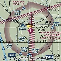
| Sectional chart |
|---|
|
| Airport distance calculator |
|---|
|
|
| Sunrise and sunset |
|---|
|
Times for 19-Jun-2026
| | Local
(UTC-5) | | Zulu
(UTC) |
|---|
| Morning civil twilight | | 05:31 | | 10:31 |
| Sunrise | | 06:04 | | 11:04 |
| Sunset | | 21:00 | | 02:00 |
| Evening civil twilight | | 21:32 | | 02:32 |
|
| Current date and time |
|---|
| Zulu (UTC) | 19-Jun-2026 12:46:08 |
|---|
| Local (UTC-5) | 19-Jun-2026 07:46:08 |
|---|
|
| METAR |
|---|
| KCNK | 191155Z AUTO 00000KT 10SM CLR 14/12 A3000 RMK AO2 SLP148 T01440117 10194 20133 58001 $
|
|
| TAF |
|---|
KSLN
46nm S | 191124Z 1912/2012 VRB03KT P6SM SCT050 FM191500 15010KT P6SM BKN060 FM191800 17012KT P6SM SCT060 FM200100 12006KT P6SM SCT060
|
|
| NOTAMs |
|---|
NOTAMs are issued by the DoD/FAA and will open in a separate window not controlled by AirNav.
|
|

