FAA INFORMATION EFFECTIVE 14 MAY 2026
Location
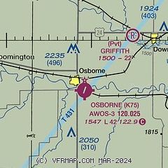
| FAA Identifier: | K75 |
| Lat/Long: | 39-25-59.8550N 098-40-48.0650W
39-25.997583N 098-40.801083W
39.4332931,-98.6800181
(estimated) |
| Elevation: | 1547 ft. / 471.5 m (surveyed) |
| Variation: | 08E (1985) |
| From city: | 1 mile SE of OSBORNE, KS |
| Time zone: | UTC -5 (UTC -6 during Standard Time) |
| Zip code: | 67473 |
Airport Operations
| Airport use: | Open to the public |
| Activation date: | 03/1947 |
| Control tower: | no |
| ARTCC: | KANSAS CITY CENTER |
| FSS: | WICHITA FLIGHT SERVICE STATION |
| NOTAMs facility: | ICT (NOTAM-D service available) |
| Attendance: | ON CALL
AMGR. |
| Wind indicator: | yes |
| Segmented circle: | no |
| Lights: | SS-SR |
| Beacon: | white-green (lighted land airport)
Operates sunset to sunrise. |
Airport Communications
| CTAF: | 122.9 |
| WX AWOS-2: | 120.025 (785-345-4998) |
Airport Services
| Fuel available: | 100LL
100LL:AMGR. |
| Parking: | hangars and tiedowns |
Runway Information
Runway 2/20
| Dimensions: | 4206 x 60 ft. / 1282 x 18 m |
| Surface: | asphalt, in good condition |
| Runway edge lights: | medium intensity
NSTD SPACED BLUE THR LGTS. |
| RUNWAY 2 | | RUNWAY 20 |
| Latitude: | 39-25.675222N | | 39-26.266852N |
| Longitude: | 098-41.035178W | | 098-40.570428W |
| Elevation: | 1546.9 ft. | | 1543.1 ft. |
| Traffic pattern: | left | | left |
| Displaced threshold: | 101 ft. | | 152 ft. |
| Markings: | nonprecision, in good condition | | nonprecision, in good condition |
| Touchdown point: | yes, no lights | | yes, no lights |
| Obstructions: | 30 ft. trees, 301 ft. from runway, 134 ft. left of centerline, 3:1 slope to clear
OBSTN CLNC SLP 12:1 TO DTHR. | | 15 ft. road, 201 ft. from runway, 125 ft. left and right of centerline
CLOSE-IN OBSTN 15 FT RD, 0-199 FT DSTC, 125 FT L/R. |
Runway 12/30
| Dimensions: | 2907 x 80 ft. / 886 x 24 m |
| Surface: | turf, in good condition |
| Runway edge markings: | THR & EDGES 8 IN X 10 FT STEEL BEAMS. |
| Operational restrictions: | OPEN SR-SS ONLY. |
| RUNWAY 12 | | RUNWAY 30 |
| Latitude: | 39-26.210423N | | 39-25.861527N |
| Longitude: | 098-41.009957W | | 098-40.587235W |
| Elevation: | 1547.0 ft. | | 1540.0 ft. |
| Traffic pattern: | left | | left |
| Markings: | NSTD | | NSTD |
| Touchdown point: | yes, no lights | | yes, no lights |
| Obstructions: | 63 ft. ant, 588 ft. from runway, 135 ft. left of centerline, 9:1 slope to clear
CTLG OBSTN EXCEEDS 45 DEG SLP. | | 8 ft. crops, 125 ft. left and right of centerline
CROPS SURROUND RWY. |
Airport Ownership and Management from official FAA records
| Ownership: | Publicly-owned |
| Owner: | CITY OF OSBORNE
128 N FIRST
OSBORNE, KS 67473
Phone 785-346-5611 |
| Manager: | BARRY CURRY
128 N FIRST
OSBORNE, KS 67473
Phone 785-476-5270 |
Additional Remarks
| - | FOR CD CTC KANSAS CITY ARTCC AT 913-254-8508. |
Instrument Procedures
There are no published instrument procedures at K75.
Some nearby airports with instrument procedures:
K82 - Smith Center Municipal Airport (20 nm N)
K61 - Moritz Memorial Airport (26 nm E)
KRCP - Rooks County Regional Airport (29 nm W)
KRSL - Russell Municipal Airport (34 nm S)
KPHG - Phillipsburg Municipal Airport (35 nm NW)
|
|

Road maps at:
MapQuest
Bing
Google
| Aerial photo |
|---|
WARNING: Photo may not be current or correct

Do you have a better or more recent aerial photo of Osborne Municipal Airport that you would like to share? If so, please send us your photo.
|
| Sectional chart |
|---|
|
| Airport distance calculator |
|---|
|
|
| Sunrise and sunset |
|---|
|
Times for 19-May-2026
| | Local
(UTC-5) | | Zulu
(UTC) |
|---|
| Morning civil twilight | | 05:48 | | 10:48 |
| Sunrise | | 06:18 | | 11:18 |
| Sunset | | 20:44 | | 01:44 |
| Evening civil twilight | | 21:15 | | 02:15 |
|
| Current date and time |
|---|
| Zulu (UTC) | 19-May-2026 06:21:01 |
|---|
| Local (UTC-5) | 19-May-2026 01:21:01 |
|---|
|
| METAR |
|---|
KK82
20nm N | 190555Z AUTO 34020G28KT 10SM OVC018 09/06 A3002 RMK AO2 T00900063 10110 20090
|
KRSL
35nm S | 190553Z AUTO 34023G34KT 10SM BKN020 09/05 A2997 RMK AO2 PK WND 35034/0545 SLP142 T00940050 10128 20094 402280094 50005
|
KPHG
35nm NW | 190555Z AUTO 33018G22KT 10SM OVC022 08/05 A3005 RMK AO2 10113 20083
|
|
| TAF |
|---|
KRSL
35nm S | 182228Z 1822/1918 32021G31KT P6SM BKN015 OVC050 FM191100 34015G25KT P6SM BKN025
|
|
| NOTAMs |
|---|
NOTAMs are issued by the DoD/FAA and will open in a separate window not controlled by AirNav.
|
|

