FAA INFORMATION EFFECTIVE 20 FEBRUARY 2025
Location
| FAA Identifier: | ALM |
| Lat/Long: | 32-50-21.9000N 105-59-28.1000W
32-50.365000N 105-59.468333W
32.8394167,-105.9911389
(estimated) |
| Elevation: | 4199.9 ft. / 1280.1 m (surveyed) |
| Variation: | 08E (2020) |
| From city: | 4 miles SW of ALAMOGORDO, NM |
| Time zone: | UTC -7 (UTC -6 during Daylight Saving Time) |
| Zip code: | 88310 |
Airport Operations
| Airport use: | Open to the public |
| Activation date: | 10/1959 |
| Control tower: | no |
| ARTCC: | ALBUQUERQUE CENTER |
| FSS: | ALBUQUERQUE FLIGHT SERVICE STATION |
| NOTAMs facility: | ALM (NOTAM-D service available) |
| Attendance: | 0700-1700
AFT HR - 575-437-2474. |
| Wind indicator: | lighted |
| Segmented circle: | yes |
| Lights: | ACTVT PAPI RWY 04; VASI RWY 22; MIRL RWY 04/22 - CTAF. MIRL RWY 04/22 PRESET MED INTST; INCR INTST - CTAF. |
| Beacon: | white-green (lighted land airport)
Operates sunset to sunrise. |
Airport Communications
| CTAF/UNICOM: | 122.8 |
| WX AWOS-3: | 127.825 (575-439-4112) |
| HOLLOMAN APPROACH: | 120.6 |
| HOLLOMAN DEPARTURE: | 128.1 |
- APCH/DEP SVC PRVDD BY ALBUQUERQUE ARTCC (ZAB) ON FREQS 132.65/257.6 (ALAMOGORDO RCAG) WHEN HOLLOMAN APCH CTL (HMN) CLSD.
Nearby radio navigation aids
| VOR radial/distance | | VOR name | | Freq | | Var |
|---|
| PIOr286/39.3 | | PINON VOR/DME | | 110.40 | | 12E |
Airport Services
| Fuel available: | 100LL JET-A1+ |
| Parking: | hangars and tiedowns |
| Airframe service: | MAJOR |
| Powerplant service: | MAJOR |
| Bulk oxygen: | HIGH |
Runway Information
Runway 4/22
| Dimensions: | 9207 x 150 ft. / 2806 x 46 m |
| Surface: | asphalt/porous friction courses, in good condition |
| Weight bearing capacity: | | PCN 48 /F/B/X/T | | Single wheel: | 54.0 | | Double wheel: | 74.0 | | Double tandem: | 120.0 |
|
| Runway edge lights: | medium intensity |
| Operational restrictions: | RWY 22 CALM WIND RWY WHEN LESS THAN 5 KTS. 200 FT BLAST PADS MKD BY CHEVRONS. |
| RUNWAY 4 | | RUNWAY 22 |
| Latitude: | 32-49.737985N | | 32-50.800737N |
| Longitude: | 106-00.230808W | | 105-58.947098W |
| Elevation: | 4127.0 ft. | | 4199.9 ft. |
| Traffic pattern: | right | | left |
| Runway heading: | 038 magnetic, 046 true | | 218 magnetic, 226 true |
| Declared distances: | TORA:9207 TODA:9207 ASDA:9207 LDA:9207 | | TORA:9207 TODA:9207 ASDA:9207 LDA:9207 |
| Markings: | nonprecision, in good condition | | nonprecision, in good condition |
| Visual slope indicator: | 4-light PAPI on right (3.00 degrees glide path) | | 2-box VASI on left (3.00 degrees glide path) |
| Runway end identifier lights: | yes | | yes |
| Touchdown point: | yes, no lights | | yes, no lights |
Helipad H1
| Dimensions: | 105 x 135 ft. / 32 x 41 m |
| Surface: | asphalt |
| Latitude: | 32-50.294167N | | |
| Longitude: | 105-59.680417W | | |
| Elevation: | 4163.0 ft. | | |
| Traffic pattern: | left | | left |
Runway 17/35
| Dimensions: | 3257 x 190 ft. / 993 x 58 m |
| Surface: | dirt, in fair condition |
| Operational restrictions: | OPS DURG WET COND NA; FOR COND - 575-551-6245. |
| RUNWAY 17 | | RUNWAY 35 |
| Latitude: | 32-50.904990N | | 32-50.370965N |
| Longitude: | 105-59.161702W | | 105-59.094418W |
| Elevation: | 4195.0 ft. | | 4174.2 ft. |
| Traffic pattern: | left | | right |
| Runway heading: | 166 magnetic, 174 true | | 346 magnetic, 354 true |
| Touchdown point: | yes, no lights | | yes, no lights |
| Obstructions: | 4 ft. brush, 28 ft. from runway, 120 ft. right of centerline, 7:1 slope to clear | | 4 ft. brush, 105 ft. right of centerline |
Airport Ownership and Management from official FAA records
| Ownership: | Publicly-owned |
| Owner: | CITY OF ALAMOGORDO
1376 E 9TH STREET
ALAMOGORDO, NM 88310
Phone 505-439-4100 |
| Manager: | TROY ORR
3500 AIRPORT ROAD
ALAMOGORDO, NM 88310
Phone 575-439-4110 |
Additional Remarks
| A58-04 | +3-8 FT BRUSH 0-200 FT FM RWY END 165-250 FT R OF CNTRLN. |
| - | 8000 FT MTS 4 NM E. |
| - | VFR OPS BTN EL PASO & ALAMOGORDO-WHITE SANDS FLW & RMN W OF HWY 54 & TRAIN TRACKS; RMN CLEAR OF RSTRD ASP. |
| - | MIL, GLIDER, ULTRALIGHT & UNMANNED AERIAL VEHICLE ACT ON & INVOF ARPT. |
| - | HOLLOMAN RAPCON IFR SDBY SVC 60 MIN RECALL - 575-572-7575. |
| - | FOR CD IF UNA TO CTC ON FSS FREQ, CTC ALBUQUERQUE ARTCC AT 505-856-4561. |
Instrument Procedures
NOTE: All procedures below are presented as PDF files. If you need a reader for these files, you should download the free Adobe Reader.NOT FOR NAVIGATION. Please procure official charts for flight.
FAA instrument procedures published for use from 20 February 2025 at 0901Z to 20 March 2025 at 0900Z.
IAPs - Instrument Approach Procedures |
|---|
| RNAV (GPS) RWY 04 | |
download (342KB) |
| NOTE: Special Alternate Minimums apply | |
download (149KB) |
|
|---|
| CORONA ONE (OBSTACLE) (RNAV) | |
download (184KB) |
| NOTE: Special Take-Off Minimums/Departure Procedures apply | |
download (298KB) |
Other nearby airports with instrument procedures:
KHMN - Holloman Air Force Base (6 nm W)
KSRR - Sierra Blanca Regional Airport (44 nm NE)
KLRU - Las Cruces International Airport (57 nm SW)
KBIF - Biggs Army Airfield (Fort Bliss) (63 nm S)
KELP - El Paso International Airport (65 nm S)
|
|

Road maps at:
MapQuest
Bing
Google
| Aerial photo |
|---|
WARNING: Photo may not be current or correct
 Photo by Jan Krumbach
Photo taken 02-Aug-2008
Photo by Jan Krumbach
Photo taken 02-Aug-2008
Do you have a better or more recent aerial photo of Alamogordo-White Sands Regional Airport that you would like to share? If so, please send us your photo.
|
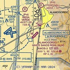
| Sectional chart |
|---|
|
CAUTION: Diagram may not be current

| Airport distance calculator |
|---|
|
|
| Sunrise and sunset |
|---|
|
Times for 10-Mar-2025
| | Local
(UTC-7) | | Zulu
(UTC) |
|---|
| Morning civil twilight | | 05:57 | | 12:57 |
| Sunrise | | 06:22 | | 13:22 |
| Sunset | | 18:07 | | 01:07 |
| Evening civil twilight | | 18:32 | | 01:32 |
|
| Current date and time |
|---|
| Zulu (UTC) | 10-Mar-2025 13:36:24 |
|---|
| Local (UTC-7) | 10-Mar-2025 06:36:24 |
|---|
|
| METAR |
|---|
KALM
2nm SE | 101315Z AUTO 00000KT 10SM CLR 00/M11 A3020 RMK AO2
|
KHMN
5nm W | 101255Z AUTO 36003KT 10SM CLR M02/M17 A3022 RMK AO2 SLP213 T10241169 $
|
|
| TAF |
|---|
KHMN
5nm W | 100900Z 1009/1115 VRB06KT 9999 FEW200 QNH2999INS TX21/1022Z TNM01/1013Z
|
|
| NOTAMs |
|---|
NOTAMs are issued by the DoD/FAA and will open in a separate window not controlled by AirNav.
|
|


