FAA INFORMATION EFFECTIVE 09 JULY 2026
Location
| FAA Identifier: | ALS |
| Lat/Long: | 37-26-06.4500N 105-52-04.3510W
37-26.107500N 105-52.072517W
37.4351250,-105.8678753
(estimated) |
| Elevation: | 7539.8 ft. / 2298.1 m (surveyed) |
| Variation: | 09E (2010) |
| From city: | 2 miles S of ALAMOSA, CO |
| Time zone: | UTC -6 (UTC -7 during Standard Time) |
| Zip code: | 81101 |
Airport Operations
| Airport use: | Open to the public |
| Activation date: | 03/1941 |
| Control tower: | no |
| ARTCC: | DENVER CENTER |
| FSS: | DENVER FLIGHT SERVICE STATION |
| NOTAMs facility: | ALS (NOTAM-D service available) |
| Attendance: | 0800-1930
ON CALL - 719-587-5335. |
| Wind indicator: | lighted |
| Segmented circle: | yes |
| Lights: | ACTVT MALSR RWY 02; REIL RWY 20; VASI RWY 20; HIRL RWY 02/20 - CTAF 122.8 |
| Beacon: | white-green (lighted land airport)
Operates sunset to sunrise. |
| Fire and rescue: | ARFF index A |
Airport Communications
| CTAF/UNICOM: | 122.8 |
| WX ASOS: | 135.175 (719-223-0010) |
- APCH/DEP CTL SVC PRVDD BY DENVER ARTCC (ZDV) ON FREQS 128.375/379.95 (ALAMOSA RCAG).
Nearby radio navigation aids
| VOR radial/distance | | VOR name | | Freq | | Var |
|---|
| ALSr321/5.7 | | ALAMOSA VORTAC | | 113.90 | | 13E |
Airport Services
| Fuel available: | 100LL JET-A |
| Parking: | hangars and tiedowns |
| Airframe service: | MAJOR |
| Powerplant service: | MAJOR |
| Bottled oxygen: | HIGH/LOW |
| Bulk oxygen: | HIGH/LOW |
Runway Information
Runway 2/20
| Dimensions: | 8521 x 100 ft. / 2597 x 30 m |
| Surface: | asphalt/grooved, in good condition |
| Runway edge lights: | high intensity |
| RUNWAY 2 | | RUNWAY 20 |
| Latitude: | 37-25.510877N | | 37-26.704097N |
| Longitude: | 105-52.535902W | | 105-51.609013W |
| Elevation: | 7539.5 ft. | | 7539.3 ft. |
| Traffic pattern: | left | | left |
| Runway heading: | 023 magnetic, 032 true | | 203 magnetic, 212 true |
| Declared distances: | TORA:8519 TODA:8519 ASDA:8519 LDA:8519 | | TORA:8519 TODA:8519 ASDA:8519 LDA:8519 |
| Markings: | precision, in fair condition | | precision, in fair condition |
| Visual slope indicator: | 4-light PAPI on left (3.00 degrees glide path) | | 4-box VASI on left (3.00 degrees glide path) |
| Approach lights: | MALSR: 1,400 foot medium intensity approach lighting system with runway alignment indicator lights | | |
| Runway end identifier lights: | no | | yes |
| Touchdown point: | yes, no lights | | yes, no lights |
| Instrument approach: | ILS | | |
| Obstructions: | none | | 40 ft. tree, 1310 ft. from runway, 15 ft. right of centerline, 27:1 slope to clear |
Airport Ownership and Management from official FAA records
| Ownership: | Publicly-owned |
| Owner: | CITY AND CO OF ALAMOSA
2490 STATE AVE
ALAMOSA, CO 81101
Phone 719-587-5211 |
| Manager: | SIRAH MASTERS
2490 STATE AVE
ALAMOSA, CO 81101
Phone 719-587-5211 |
Additional Remarks
| A39-02/20 | PCR VALUE: 392/F/C/X/T |
| - | APRON GA RAMP CLSD TO ACRS. |
| - | CONDS UNMON AT NGT AFT LAST ACR ARR TIL 0600; SEE NOTAMS FOR CONDS. |
| - | FOR CD CTC DENVER ARTCC ON FREQ. IF UNA, CTC FSS ON FREQ VIA RCO. IF UNA, CTC DENVER ARTCC AT 303-651-4257. |
| - | PPR FOR UNSKED AIR CARRIER OPNS CALL ARPT OPS 719-588-4881 OR 719-588-4871. |
| - | ARFF COVERAGE PROVDD DURG ACR OPS; OTR TIMES 24 HR PPR - ARPT OPS 719-588-4881/4871. |
| - | HOP ON & INVOF ARPT. |
| - | COLD TEMPERATURE AIRPORT. ALTITUDE CORRECTION REQUIRED AT OR BELOW -25C. |
Instrument Procedures
NOTE: All procedures below are presented as PDF files. If you need a reader for these files, you should download the free Adobe Reader.NOT FOR NAVIGATION. Please procure official charts for flight.
FAA instrument procedures published for use from 09 July 2026 at 0901Z to 06 August 2026 at 0900Z.
IAPs - Instrument Approach Procedures |
|---|
| ILS OR LOC RWY 02 | |
download (283KB) |
| RNAV (GPS) RWY 02 | |
download (270KB) |
| RNAV (GPS) RWY 20 | |
download (241KB) |
| VOR-B | |
download (260KB) |
| NOTE: Special Take-Off Minimums/Departure Procedures apply | |
download (288KB) |
Other nearby airports with instrument procedures:
KMVI - Monte Vista Municipal Airport (10 nm NW)
KRCV - Astronaut Kent Rominger Airport (28 nm NW)
4V1 - Spanish Peaks Airfield (54 nm E)
KPSO - Stevens Field Airport (57 nm W)
KSKX - Taos Regional Airport (60 nm S)
|
|

Road maps at:
MapQuest
Bing
Google
| Aerial photo |
|---|
WARNING: Photo may not be current or correct

Do you have a better or more recent aerial photo of San Luis Valley Regional Airport/Bergman Field that you would like to share? If so, please send us your photo.
|
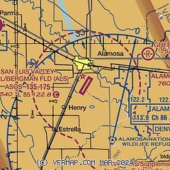
| Sectional chart |
|---|
|
CAUTION: Diagram may not be current

| Airport distance calculator |
|---|
|
|
| Sunrise and sunset |
|---|
|
Times for 16-Jul-2026
| | Local
(UTC-6) | | Zulu
(UTC) |
|---|
| Morning civil twilight | | 05:26 | | 11:26 |
| Sunrise | | 05:56 | | 11:56 |
| Sunset | | 20:23 | | 02:23 |
| Evening civil twilight | | 20:53 | | 02:53 |
|
| Current date and time |
|---|
| Zulu (UTC) | 16-Jul-2026 15:07:25 |
|---|
| Local (UTC-6) | 16-Jul-2026 09:07:25 |
|---|
|
| METAR |
|---|
| KALS | 161452Z AUTO VRB03KT 10SM BKN100 17/11 A3035 RMK AO2 SLP191 T01670106 50001 PNO
|
|
| TAF |
|---|
| KALS | 161120Z 1612/1712 VRB06KT P6SM SCT110 FM161600 13007KT P6SM FEW120 FM162000 12012G20KT P6SM SCT100 BKN150 PROB30 1621/1701 VRB25G40KT -TSRA BKN090CB FM170100 10009KT P6SM BKN120 FM170600 VRB06KT P6SM FEW140 SCT250
|
|
| NOTAMs |
|---|
NOTAMs are issued by the DoD/FAA and will open in a separate window not controlled by AirNav.
|
|


