FAA INFORMATION EFFECTIVE 09 JULY 2026
Location
| FAA Identifier: | 4V1 |
| Lat/Long: | 37-41-47.5041N 104-47-05.8547W
37-41.791735N 104-47.097578W
37.6965289,-104.7849596
(estimated) |
| Elevation: | 6054.7 ft. / 1845.5 m (surveyed) |
| Variation: | 08E (2015) |
| From city: | 5 miles N of WALSENBURG, CO |
| Time zone: | UTC -6 (UTC -7 during Standard Time) |
| Zip code: | 81089 |
Airport Operations
| Airport use: | Open to the public |
| Activation date: | 03/1949 |
| Control tower: | no |
| ARTCC: | DENVER CENTER |
| FSS: | DENVER FLIGHT SERVICE STATION |
| NOTAMs facility: | DEN (NOTAM-D service available) |
| Attendance: | IREG |
| Wind indicator: | lighted |
| Segmented circle: | no |
| Lights: | ACTVT PAPI RWY 09 & 27; MIRL RWY 09/27 - CTAF. |
Airport Communications
| CTAF/UNICOM: | 122.8 |
| WX AWOS-3PT: | 123.6 (719-738-1053) |
- APCH/DEP CTL SVC PRVDD BY DENVER ARTCC (ZDV) ON FREQS 128.375/379.95 (ALAMOSA RCAG).
Nearby radio navigation aids
| VOR radial/distance | | VOR name | | Freq | | Var |
|---|
| PUBr197/39.6 | | PUEBLO VORTAC | | 116.70 | | 08E |
Airport Services
| Fuel available: | 100LL JET-A
100LL:24 HR CREDIT CARD FUEL AVBL. |
| Parking: | tiedowns |
| Bottled oxygen: | NONE |
| Bulk oxygen: | NONE |
Runway Information
Runway 9/27
| Dimensions: | 4715 x 75 ft. / 1437 x 23 m |
| Surface: | asphalt, in good condition |
| Weight bearing capacity: | | PCN 5 /F/C/Y/T | | Single wheel: | 17.0 | | Double wheel: | 17.0 |
|
| Runway edge lights: | medium intensity |
| RUNWAY 9 | | RUNWAY 27 |
| Latitude: | 37-41.822295N | | 37-41.771107N |
| Longitude: | 104-47.497378W | | 104-46.521992W |
| Elevation: | 6046.9 ft. | | 6019.1 ft. |
| Traffic pattern: | left | | left |
| Runway heading: | 085 magnetic, 093 true | | 265 magnetic, 273 true |
| Displaced threshold: | 210 ft. | | no |
| Declared distances: | TORA:4502 TODA:4502 ASDA:4502 LDA:4502 | | TORA:4712 TODA:4712 ASDA:4712 LDA:4712 |
| Markings: | nonprecision, in good condition | | nonprecision, in good condition |
| Visual slope indicator: | 2-light PAPI on left (3.00 degrees glide path) | | 2-light PAPI on left (3.00 degrees glide path) |
| Touchdown point: | yes, no lights | | yes, no lights |
Runway 2/20
| Dimensions: | 2238 x 40 ft. / 682 x 12 m |
| Surface: | turf/dirt, in fair condition
RWY 02 ROUGH AND NOT WELL MAINTAINED.
RWY 02 FIRST 1000 FT HAS RUTS AND BUMPS. |
| Operational restrictions: | RWY 02/20 CLSD EXCP PPR CTC AMGR PRIOR TO USE 719-742-5323 OR 719-859-5323. |
| RUNWAY 2 | | RUNWAY 20 |
| Latitude: | 37-41.622598N | | 37-41.939950N |
| Longitude: | 104-47.400830W | | 104-47.164668W |
| Elevation: | 6054.7 ft. | | 6033.0 ft. |
| Traffic pattern: | left | | left |
| Runway heading: | 023 magnetic, 031 true | | 203 magnetic, 211 true |
| Declared distances: | TORA:2012 TODA:2012 ASDA:2012 LDA:2012 | | TORA:2012 TODA:2012 ASDA:2012 LDA:2012 |
| Markings: | NSTD, in fair condition | | NSTD, in fair condition |
| Touchdown point: | yes, no lights | | yes, no lights |
| Obstructions: | 12 ft. fence, 200 ft. from runway, 16:1 slope to clear
RWY 02 5 FT FENCE AT THLD BOTH SIDES OF CNTRLN. | | none
RWY 20 4 FT FENCE 240 FT FM THLD BOTH SIDES OF CNTRLN. |
Airport Ownership and Management from official FAA records
| Ownership: | Publicly-owned |
| Owner: | HUERFANO COUNTY
COUNTY COURTHOUSE
WALSENBURG, CO 81089
Phone 719-738-2370 |
| Manager: | DUSTIN HRIBAR
401 MAIN ST
WALSENBURG, CO 81089
Phone 719-989-0376 |
Additional Remarks
| A57-09 | APCH SLOPE 50:1 FM DTHR. |
| - | BE ALERT: INTENSIVE USAF STUDENT TRNG ACT INVOF COLORADO SPRINGS & PUEBLO, CO. |
| - | FOR CD CTC DENVER ARTCC AT 303-651-4257. |
Instrument Procedures
NOTE: All procedures below are presented as PDF files. If you need a reader for these files, you should download the free Adobe Reader.NOT FOR NAVIGATION. Please procure official charts for flight.
FAA instrument procedures published for use from 09 July 2026 at 0901Z to 06 August 2026 at 0900Z.
IAPs - Instrument Approach Procedures |
|---|
| RNAV (GPS) RWY 09 | |
download (384KB) |
| RNAV (GPS) RWY 27 | |
download (301KB) |
|
|---|
| GOSIP ONE (OBSTACLE) (RNAV) | |
download (214KB) |
| NOTE: Special Take-Off Minimums/Departure Procedures apply | |
download (105KB) |
Other nearby airports with instrument procedures:
KTAD - Perry Stokes Airport (34 nm SE)
KPUB - Pueblo Memorial Airport (38 nm N)
1V6 - Fremont County Airport (46 nm N)
KALS - San Luis Valley Regional Airport/Bergman Field (54 nm W)
KRTN - Raton Municipal Airport/Crews Field (59 nm S)
|
|

Road maps at:
MapQuest
Bing
Google
| Aerial photo |
|---|
WARNING: Photo may not be current or correct
 Photo taken 08-Nov-2012
looking northeast.
Photo taken 08-Nov-2012
looking northeast.
Do you have a better or more recent aerial photo of Spanish Peaks Airfield that you would like to share? If so, please send us your photo.
|
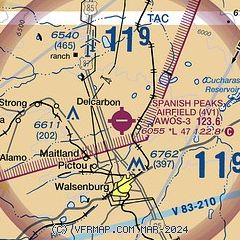
| Sectional chart |
|---|
|
CAUTION: Diagram may not be current

| Airport distance calculator |
|---|
|
|
| Sunrise and sunset |
|---|
|
Times for 14-Jul-2026
| | Local
(UTC-6) | | Zulu
(UTC) |
|---|
| Morning civil twilight | | 05:19 | | 11:19 |
| Sunrise | | 05:50 | | 11:50 |
| Sunset | | 20:20 | | 02:20 |
| Evening civil twilight | | 20:51 | | 02:51 |
|
| Current date and time |
|---|
| Zulu (UTC) | 14-Jul-2026 08:48:32 |
|---|
| Local (UTC-6) | 14-Jul-2026 02:48:32 |
|---|
|
| METAR |
|---|
KVTP
22nm SW | 140835Z AUTO 27009KT 10SM CLR 12/03 A3072 RMK AO2
|
KTAD
34nm SE | 140754Z AUTO 00000KT 10SM CLR 21/09 A3029 RMK AO2 SLP159 T02110089
|
KPUB
38nm N | 140753Z AUTO 09011KT 10SM CLR 22/10 A3019 RMK AO2 SLP147 T02170100
|
|
| TAF |
|---|
KPUB
38nm N | 140520Z 1406/1506 10012KT P6SM SKC FM140900 VRB06KT P6SM SKC FM141800 12012G22KT P6SM SKC
|
|
| NOTAMs |
|---|
NOTAMs are issued by the DoD/FAA and will open in a separate window not controlled by AirNav.
|
|


