FAA INFORMATION EFFECTIVE 22 JANUARY 2026
Location
| FAA Identifier: | 1V6 |
| Lat/Long: | 38-25-42.8168N 105-06-24.6759W
38-25.713613N 105-06.411265W
38.4285602,-105.1068544
(estimated) |
| Elevation: | 5442.4 ft. / 1658.8 m (surveyed) |
| Variation: | 08E (2020) |
| From city: | 6 miles E of CANON CITY, CO |
| Time zone: | UTC -7 (UTC -6 during Daylight Saving Time) |
| Zip code: | 81240 |
Airport Operations
| Airport use: | Open to the public |
| Activation date: | 03/1941 |
| Control tower: | no |
| ARTCC: | DENVER CENTER |
| FSS: | DENVER FLIGHT SERVICE STATION |
| NOTAMs facility: | DEN (NOTAM-D service available) |
| Attendance: | 0800-1700 |
| Pattern altitude: | 6500.4 ft. MSL |
| Wind indicator: | lighted |
| Segmented circle: | no |
| Lights: | ACTVT REIL RWY 11 & 29; PAPI RWY 11 & 29; MIRL RWY 11/29 - CTAF. |
| Beacon: | white-green (lighted land airport)
Operates sunset to sunrise. |
Airport Communications
| CTAF/UNICOM: | 122.8 |
| WX AWOS-3: | 120.025 ((719) 784-2014) |
| DENVER APPROACH: | 120.1 |
| DENVER DEPARTURE: | 120.1 |
- DENVER APCH CTL (D01) PRVDD APCH/DEP CTL SVC FM 0600-2200; DENVER ARTCC (ZDV) PRVDD APCH/DEP CTL SVC FM 2200-0600 ON FREQS 128.375/379.95 (PUEBLO RCAG).
Nearby radio navigation aids
| VOR radial/distance | | VOR name | | Freq | | Var |
|---|
| FCSr215/22.3 | | BUTTS VOR/DME | | 108.80 | | 12E |
| PUBr276/32.9 | | PUEBLO VORTAC | | 116.70 | | 08E |
| BRKr208/38.1 | | BLACK FOREST VOR/DME | | 112.50 | | 08E |
| NDB name | | Hdg/Dist | | Freq | | Var | | ID |
|---|
| IRONHORSE | | 220/22.4 | | 335 | | 08E | | IHS | .. .... ... |
Airport Services
| Fuel available: | 100LL JET-A |
| Parking: | hangars and tiedowns |
| Airframe service: | MAJOR |
| Powerplant service: | MAJOR |
| Bulk oxygen: | HIGH/LOW |
Runway Information
Runway 11/29
| Dimensions: | 5399 x 75 ft. / 1646 x 23 m |
| Surface: | asphalt, in good condition |
| Weight bearing capacity: | | Single wheel: | 26.0 | | Double wheel: | 26.0 |
|
| Runway edge lights: | medium intensity |
| RUNWAY 11 | | RUNWAY 29 |
| Latitude: | 38-26.012248N | | 38-25.556023N |
| Longitude: | 105-06.996765W | | 105-06.026477W |
| Elevation: | 5442.4 ft. | | 5381.8 ft. |
| Traffic pattern: | left | | left |
| Runway heading: | 113 magnetic, 121 true | | 293 magnetic, 301 true |
| Markings: | nonprecision, in fair condition | | precision, in fair condition |
| Visual slope indicator: | 2-light PAPI on left (3.00 degrees glide path) | | 2-light PAPI on left (3.00 degrees glide path) |
| Runway end identifier lights: | yes | | yes |
| Touchdown point: | yes, no lights | | yes, no lights |
Runway 17/35
| Dimensions: | 1800 x 35 ft. / 549 x 11 m
VRBL 35 - 45 FT. |
| Surface: | turf/gravel, in poor condition
PRARIE DOG HOLES THRUT.
CROSSES ASPH TWY & RWY. |
| RUNWAY 17 | | RUNWAY 35 |
| Latitude: | 38-25.650333N | | 38-25.353833N |
| Longitude: | 105-06.112000W | | 105-06.108500W |
| Elevation: | 5386.4 ft. | | 5364.0 ft. |
| Traffic pattern: | left | | left |
| Runway heading: | 171 magnetic, 179 true | | 351 magnetic, 359 true |
| Touchdown point: | yes, no lights | | yes, no lights |
| Obstructions: | 30 ft. bldg, 1270 ft. from runway, 35 ft. left of centerline, 42:1 slope to clear | | none |
Airport Ownership and Management from official FAA records
| Ownership: | Publicly-owned |
| Owner: | FREMONT COUNTY
615 MACON
CANON CITY, CO 81212
Phone 719-276-7300 |
| Manager: | WESLEY BRANDT
60298 HIGHWAY 50
PENROSE, CO 81240
Phone 719-784-3816
AFT HR - 719-429-3816. |
Additional Remarks
| A30A-17 | +32 FT HNGR 1495 FT FM THR 100 FT R OF EXTNDD CNTRLN. |
| - | APRON AREAS LGTD. |
| - | FOR CD CTC DENVER APCH AT 303-342-1916. |
| - | PAVED TWYS MKD WITH BLUE & WHITE REFLECTORS. |
| - | GLDR OPS & TOWING ON & INVOF ARPT. |
| - | 2 FT TRRN W OF RWY 17/35 & FIRST 250 FT S OF RWY 11/29. |
| - | CTN: USAF STUDENT TRNG INVOF COLORADO SPRINGS & PUEBLO COLORADO. |
Instrument Procedures
NOTE: All procedures below are presented as PDF files. If you need a reader for these files, you should download the free Adobe Reader.NOT FOR NAVIGATION. Please procure official charts for flight.
FAA instrument procedures published for use from 22 January 2026 at 0901Z to 19 February 2026 at 0900z.
IAPs - Instrument Approach Procedures |
|---|
| RNAV (GPS) RWY 29 | |
download (272KB) |
| NOTE: Special Take-Off Minimums/Departure Procedures apply | |
download (145KB) |
Other nearby airports with instrument procedures:
KFCS - Butts Army Airfield (Fort Carson) (22 nm NE)
KCOS - City of Colorado Springs Municipal Airport (30 nm NE)
KPUB - Pueblo Memorial Airport (30 nm E)
KFLY - Meadow Lake Airport (40 nm NE)
KANK - Salida Airport/Harriett Alexander Field (45 nm W)
|
|

Road maps at:
MapQuest
Bing
Google
| Aerial photo |
|---|
WARNING: Photo may not be current or correct
 Photo by Ray Fey
Photo taken 07-Jun-2013
looking north-northeast.
Photo by Ray Fey
Photo taken 07-Jun-2013
looking north-northeast.
Do you have a better or more recent aerial photo of Fremont County Airport that you would like to share? If so, please send us your photo.
|
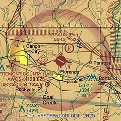
| Sectional chart |
|---|
|
| Airport distance calculator |
|---|
|
|
| Sunrise and sunset |
|---|
|
Times for 30-Jan-2026
| | Local
(UTC-7) | | Zulu
(UTC) |
|---|
| Morning civil twilight | | 06:40 | | 13:40 |
| Sunrise | | 07:08 | | 14:08 |
| Sunset | | 17:19 | | 00:19 |
| Evening civil twilight | | 17:47 | | 00:47 |
|
| Current date and time |
|---|
| Zulu (UTC) | 31-Jan-2026 05:34:57 |
|---|
| Local (UTC-7) | 30-Jan-2026 22:34:57 |
|---|
|
| METAR |
|---|
| K1V6 | 310515Z AUTO 09008KT 10SM OVC010 M02/M04 A3043 RMK AO1
|
|
| TAF |
|---|
KFCS
21nm NE | 302000Z 3020/0102 06009KT 9999 SKC QNH3029INS BECMG 3102/3103 16006KT 9999 BKN040 QNH3037INS BECMG 3107/3108 17006KT 4800 BR BKN005 OVC010 620059 QNH3029INS BECMG 3114/3115 27009KT 9999 NSW BKN080 QNH3024INS BECMG 3119/3120 22012G18KT 9999 FEW120 520309 QNH3016INS TX08/3021Z TNM03/3112Z
|
|
| NOTAMs |
|---|
NOTAMs are issued by the DoD/FAA and will open in a separate window not controlled by AirNav.
|
|


