FAA INFORMATION EFFECTIVE 12 JUNE 2025
Location
| FAA Identifier: | ANB |
| Lat/Long: | 33-35-17.4000N 085-51-29.2000W
33-35.290000N 085-51.486667W
33.5881667,-85.8581111
(estimated) |
| Elevation: | 612 ft. / 186.5 m (surveyed) |
| Variation: | 04W (2020) |
| From city: | 5 miles SW of ANNISTON, AL |
| Time zone: | UTC -5 (UTC -6 during Standard Time) |
| Zip code: | 36203 |
Airport Operations
| Airport use: | Open to the public |
| Activation date: | 03/1941 |
| Control tower: | no |
| ARTCC: | ATLANTA CENTER |
| FSS: | ANNISTON FLIGHT SERVICE STATION |
| NOTAMs facility: | ANB (NOTAM-D service available) |
| Attendance: | MON-FRI 0700-1800, ALL SAT-SUN 0800-1700
FBO SVC - 256-831-4410. |
| Wind indicator: | lighted |
| Segmented circle: | yes |
| Lights: | ACTVT MALSR RWY 05; REIL RWY 23; PAPI RWY 05 & 23, HIRL RWY 05/23 - CTAF. |
| Beacon: | white-green (lighted land airport)
Operates sunset to sunrise. |
| Airline operations: | CLSD TO SKED ACR OPS WITH MORE THAN 9 PAX SEATS & UNSKED ACR OPS WITH MORE THAN 30 PAX SEATS. |
Airport Communications
| CTAF: | 123.6 |
| UNICOM: | 123.0 |
| WX ASOS: | 119.675 (256-835-3931) |
| BIRMINGHAM APPROACH: | 132.15 |
| BIRMINGHAM DEPARTURE: | 132.15 |
| WX AWOS-3PT at ASN (10 nm W): | 118.425 (256-362-5847) |
| WX AWOS-3P at PLR (20 nm W): | 119.625 ((205) 884-4359) |
Nearby radio navigation aids
| VOR radial/distance | | VOR name | | Freq | | Var |
|---|
| GADr152/25.9 | | GADSDEN VOR/DME | | 112.30 | | 02E |
| NDB name | | Hdg/Dist | | Freq | | Var | | ID |
|---|
| BOGGA | | 053/4.9 | | 211 | | 04W | | AN | .- -. |
| CARROLLTON | | 276/36.4 | | 278 | | 04W | | GPQ | --. .--. --.- |
Airport Services
| Fuel available: | 100LL JET-A
100LL:AFT HR FUEL - 256-831-4410; SVC FEE 1800-0730. |
| Parking: | hangars and tiedowns |
| Airframe service: | MAJOR |
| Powerplant service: | MAJOR |
| Bottled oxygen: | HIGH/LOW |
Runway Information
Runway 5/23
| Dimensions: | 7000 x 150 ft. / 2134 x 46 m |
| Surface: | asphalt/grooved, in excellent condition |
| Weight bearing capacity: | | PCN 10 /F/C/X/T | | Single wheel: | 28.0 | | Double wheel: | 43.5 | | Double tandem: | 260.0 |
|
| Runway edge lights: | high intensity |
| RUNWAY 5 | | RUNWAY 23 |
| Latitude: | 33-34.907410N | | 33-35.672783N |
| Longitude: | 085-52.002965W | | 085-50.970698W |
| Elevation: | 594.7 ft. | | 612.0 ft. |
| Traffic pattern: | right | | left |
| Runway heading: | 052 magnetic, 048 true | | 232 magnetic, 228 true |
| Markings: | precision, in good condition | | nonprecision, in good condition |
| Visual slope indicator: | 4-light PAPI on left (3.00 degrees glide path) | | 4-light PAPI on left (3.00 degrees glide path) |
| Approach lights: | MALSR: 1,400 foot medium intensity approach lighting system with runway alignment indicator lights | | |
| Runway end identifier lights: | | | yes |
| Touchdown point: | yes, no lights | | yes, no lights |
| Instrument approach: | ILS | | |
| Obstructions: | none | | 40 ft. trees, 2180 ft. from runway, 75 ft. left of centerline, 25:1 slope to clear |
Airport Ownership and Management from official FAA records
| Ownership: | Publicly-owned |
| Owner: | CITY OF ANNISTON
P.O. BOX 2185
ANNISTON, AL 36202
Phone 256-831-4410 |
| Manager: | DAVID ARNETT
BOX 2168
ANNISTON, AL 36202
Phone (256) 241-7171 |
Additional Remarks
| - | BIRDS ON AND INVOF RWY. |
| - | FOR CD CTC BIRMINGHAM APCH AT 205-769-3890. |
Instrument Procedures
NOTE: All procedures below are presented as PDF files. If you need a reader for these files, you should download the free Adobe Reader.NOT FOR NAVIGATION. Please procure official charts for flight.
FAA instrument procedures published for use from 12 June 2025 at 0901Z to 10 July 2025 at 0900z.
IAPs - Instrument Approach Procedures |
|---|
| ILS Y OR LOC Y RWY 05 | |
download (278KB) |
| ILS Z OR LOC Z RWY 05 | |
download (279KB) |
| RNAV (GPS) RWY 05 | |
download (235KB) |
| RNAV (GPS) RWY 23 | |
download (271KB) |
| NOTE: Special Alternate Minimums apply | |
download |
| NOTE: Special Take-Off Minimums/Departure Procedures apply | |
download (665KB) |
Other nearby airports with instrument procedures:
KASN - Talladega Municipal Airport (10 nm W)
KPLR - St Clair County Airport (20 nm W)
KGAD - Northeast Alabama Regional Airport (26 nm NW)
KPYP - Centre Piedmont/Cherokee County Regional Airport (33 nm N)
KSCD - Merkel Field Sylacauga Municipal Airport (34 nm SW)
|
|

Road maps at:
MapQuest
Bing
Google
| Aerial photo |
|---|
WARNING: Photo may not be current or correct

Do you have a better or more recent aerial photo of Anniston Regional Airport that you would like to share? If so, please send us your photo.
|
| Sectional chart |
|---|
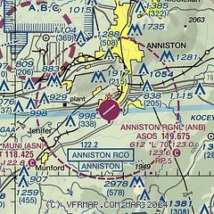
|
| Airport distance calculator |
|---|
|
|
| Sunrise and sunset |
|---|
|
Times for 27-Jun-2025
| | Local
(UTC-5) | | Zulu
(UTC) |
|---|
| Morning civil twilight | | 05:07 | | 10:07 |
| Sunrise | | 05:36 | | 10:36 |
| Sunset | | 19:57 | | 00:57 |
| Evening civil twilight | | 20:26 | | 01:26 |
|
| Current date and time |
|---|
| Zulu (UTC) | 27-Jun-2025 08:37:24 |
|---|
| Local (UTC-5) | 27-Jun-2025 03:37:24 |
|---|
|
| METAR |
|---|
| KANB | 270822Z AUTO 00000KT 8SM BKN001 22/22 A3009 RMK AO2 T02220222
|
KASN
10nm W | 270815Z AUTO 18002KT 7SM CLR 23/23 A3007 RMK AO2
|
KPLR
20nm W | 270815Z AUTO 00000KT 6SM BR FEW070 22/22 A3009 RMK A01
|
|
| TAF |
|---|
KASN
10nm W | 270520Z 2706/2806 07002KT P6SM FEW035 FEW050 FM270900 00000KT 2SM BR SCT035 FM271300 22003KT P6SM FEW035 PROB30 2718/2724 4SM SHRA BR SCT035
|
|
| NOTAMs |
|---|
NOTAMs are issued by the DoD/FAA and will open in a separate window not controlled by AirNav.
|
|


