FAA INFORMATION EFFECTIVE 09 JULY 2026
Location
| FAA Identifier: | BXM |
| Lat/Long: | 43-53-32.4784N 069-56-19.7869W
43-53.541307N 069-56.329782W
43.8923551,-69.9388297
(estimated) |
| Elevation: | 74.7 ft. / 22.8 m (surveyed) |
| Variation: | 18W (1985) |
| From city: | 2 miles SE of BRUNSWICK, ME |
| Time zone: | UTC -4 (UTC -5 during Standard Time) |
| Zip code: | 04011 |
Airport Operations
| Airport use: | Open to the public |
| Activation date: | 04/1940 |
| Control tower: | no |
| ARTCC: | BOSTON CENTER |
| FSS: | BANGOR FLIGHT SERVICE STATION |
| NOTAMs facility: | BGR (NOTAM-D service available) |
| Attendance: | 0700-1900 |
| Wind indicator: | lighted |
| Segmented circle: | yes |
| Lights: | ACTVT MALSR RWY 01R; REIL RWY 19L; PAPI RWY 01R & 19L; HIRL RWY 01R/19L - CTAF. |
| Beacon: | white-green (lighted land airport)
Operates sunset to sunrise. |
Airport Communications
| CTAF/UNICOM: | 122.725 |
| WX AWOS-3PT: | 134.875 (207-409-1747) |
| PORTLAND APPROACH: | 119.75 ;112-292 120.4 ;293-111 |
| PORTLAND DEPARTURE: | 119.75 ;112-292 120.4 ;293-111 |
| CLEARANCE DELIVERY: | 123.65 |
| WX ASOS at IWI (11 nm NE): | 135.725 (207-882-8094) |
| WX AWOS-3PT at LEW (18 nm NW): | 118.025 (207-783-2806) |
- APCH/DEP SVC PRVDD BY BOSTON ARTCC ON FREQS 128.2/263.05 (WATERBORO RCAG) WHEN PORTLAND APCH CTL CLSD.
Nearby radio navigation aids
| VOR radial/distance | | VOR name | | Freq | | Var |
|---|
| AUGr211/26.4 | | AUGUSTA VOR/DME | | 114.95 | | 18W |
Airport Services
| Fuel available: | 100LL JET-A+ |
| Parking: | hangars and tiedowns |
| Airframe service: | MAJOR |
| Powerplant service: | MAJOR |
| Bottled oxygen: | HIGH/LOW |
| Bulk oxygen: | HIGH/LOW |
Runway Information
Runway 1L/19R
| Dimensions: | 8000 x 200 ft. / 2438 x 61 m |
| Surface: | asphalt/concrete |
| Runway edge lights: | high intensity |
| Operational restrictions: | CLSD INDEFLY. |
| RUNWAY 1L | | RUNWAY 19R |
| Latitude: | 43-52.880445N | | 43-54.191782N |
| Longitude: | 069-56.327210W | | 069-56.491072W |
| Elevation: | 63.4 ft. | | 74.2 ft. |
| Traffic pattern: | right | | left |
| Runway heading: | 012 magnetic, 354 true | | 192 magnetic, 174 true |
| Markings: | precision, in fair condition | | precision, in fair condition |
| Visual slope indicator: | 4-light PAPI on left (3.00 degrees glide path) | | 4-light PAPI on left (3.00 degrees glide path) |
| Runway end identifier lights: | no | | no |
| Touchdown point: | yes, no lights | | yes, no lights |
Runway 1R/19L
| Dimensions: | 8000 x 200 ft. / 2438 x 61 m |
| Surface: | asphalt/concrete |
| Runway edge lights: | high intensity |
| RUNWAY 1R | | RUNWAY 19L |
| Latitude: | 43-52.890833N | | 43-54.202167N |
| Longitude: | 069-56.168483W | | 069-56.332363W |
| Elevation: | 61.6 ft. | | 73.7 ft. |
| Traffic pattern: | right | | left |
| Runway heading: | 012 magnetic, 354 true | | 192 magnetic, 174 true |
| Markings: | precision, in fair condition | | precision, in fair condition |
| Visual slope indicator: | 4-light PAPI on left (3.00 degrees glide path) | | 4-light PAPI on left (3.00 degrees glide path) |
| Approach lights: | MALSR: 1,400 foot medium intensity approach lighting system with runway alignment indicator lights | | |
| Runway end identifier lights: | | | yes |
| Touchdown point: | yes, no lights | | yes, no lights |
| Instrument approach: | ILS/DME | | |
Airport Ownership and Management from official FAA records
| Ownership: | Publicly-owned |
| Owner: | MIDCOAST RGNL REDEVELOPMENT AUTH
15 TERMINAL DRIVE
BRUNSWICK, ME 04011
Phone (207) 798-6512 |
| Manager: | JIM NALL
15 TERMINAL DRIVE
BRUNSWICK, ME 04011
Phone 207-406-2081 |
Additional Remarks
| A30A-19L | CALM WIND RWY. |
| - | BIRDS AND DEER INVOF OF ARPT. |
| - | FOR CD CTC PORTLAND APCH AT 207-874-7320, WHEN APCH CLSD CTC BOSTON ARTCC AT 603-879-6859. |
Instrument Procedures
NOTE: All procedures below are presented as PDF files. If you need a reader for these files, you should download the free Adobe Reader.NOT FOR NAVIGATION. Please procure official charts for flight.
FAA instrument procedures published for use from 09 July 2026 at 0901Z to 06 August 2026 at 0900Z.
IAPs - Instrument Approach Procedures |
|---|
| ILS OR LOC RWY 01R | |
download (289KB) |
| RNAV (GPS) RWY 01R | |
download (314KB) |
| RNAV (GPS) RWY 19L | |
download (299KB) |
| NOTE: Special Alternate Minimums apply | |
download (129KB) |
| NOTE: Special Take-Off Minimums/Departure Procedures apply | |
download (510KB) |
Other nearby airports with instrument procedures:
KIWI - Wiscasset Airport (11 nm NE)
KLEW - Auburn/Lewiston Municipal Airport (18 nm NW)
KPWM - Portland International Jetport (22 nm SW)
KAUG - Augusta State Airport (26 nm N)
81B - Oxford County Regional Airport (28 nm NW)
|
|

Road maps at:
MapQuest
Bing
Google
| Aerial photo |
|---|
WARNING: Photo may not be current or correct
 Photo by Kyle Warren Photography
Photo taken 13-Mar-2017
looking northwest.
Photo by Kyle Warren Photography
Photo taken 13-Mar-2017
looking northwest.
Do you have a better or more recent aerial photo of Brunswick Executive Airport that you would like to share? If so, please send us your photo.
|
| Sectional chart |
|---|
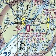
|
CAUTION: Diagram may not be current
 Download PDF
of official airport diagram from the FAA
| Airport distance calculator |
|---|
|
|
| Sunrise and sunset |
|---|
|
Times for 29-Jul-2026
| | Local
(UTC-4) | | Zulu
(UTC) |
|---|
| Morning civil twilight | | 04:53 | | 08:53 |
| Sunrise | | 05:26 | | 09:26 |
| Sunset | | 20:06 | | 00:06 |
| Evening civil twilight | | 20:40 | | 00:40 |
|
| Current date and time |
|---|
| Zulu (UTC) | 29-Jul-2026 22:49:41 |
|---|
| Local (UTC-4) | 29-Jul-2026 18:49:41 |
|---|
|
| METAR |
|---|
| KBXM | 292235Z AUTO 06008KT 10SM BKN010 OVC014 18/18 A2981 RMK AO2
|
KIWI
11nm NE | 292220Z AUTO 07006KT 10SM SCT011 OVC028 19/17 A2982 RMK AO2 RAE00 P0000 T01890167
|
KLEW
16nm NW | 292156Z AUTO 08006KT 10SM -RA OVC010 19/18 A2980 RMK AO2 SLP098 T01940183 PNO $
|
|
| NOTAMs |
|---|
NOTAMs are issued by the DoD/FAA and will open in a separate window not controlled by AirNav.
|
|


