FAA INFORMATION EFFECTIVE 09 JULY 2026
Location
| FAA Identifier: | CAO |
| Lat/Long: | 36-26-46.6480N 103-08-59.7550W
36-26.777467N 103-08.995917W
36.4462911,-103.1499319
(estimated) |
| Elevation: | 4969.8 ft. / 1514.8 m (surveyed) |
| Variation: | 09E (2005) |
| From city: | 2 miles E of CLAYTON, NM |
| Time zone: | UTC -6 (UTC -7 during Standard Time) |
| Zip code: | 88415 |
Airport Operations
| Airport use: | Open to the public |
| Activation date: | 12/1946 |
| Control tower: | no |
| ARTCC: | ALBUQUERQUE CENTER |
| FSS: | ALBUQUERQUE FLIGHT SERVICE STATION |
| NOTAMs facility: | CAO (NOTAM-D service available) |
| Attendance: | 0800-1700 |
| Wind indicator: | lighted |
| Segmented circle: | yes |
| Lights: | ACTVT PAPI RWY 02 & 20; MIRL RWY 02/20 & 12/30 - CTAF. |
| Beacon: | white-green (lighted land airport)
Operates sunset to sunrise. |
Airport Communications
| CTAF/UNICOM: | 122.8 |
| WX ASOS: | 120.625 (575-446-3045) |
- APCH/DEP SVC PRVDD BY ALBUQUERQUE ARTCC (ABQ) ON FREQS 127.85/285.475 (MOUNT DORA RCAG).
Nearby radio navigation aids
| VOR radial/distance | | VOR name | | Freq | | Var |
|---|
| DHTr294/36.2 | | DALHART VORTAC | | 112.00 | | 12E |
Airport Services
| Fuel available: | 100LL JET-A
100LL:100 LL & JET A AVBL 24-7 SELF-SVC WITH MAJOR CREDIT CARD. |
| Parking: | tiedowns |
Runway Information
Runway 2/20
| Dimensions: | 6307 x 75 ft. / 1922 x 23 m |
| Surface: | asphalt, in fair condition |
| Weight bearing capacity: | | PCN 6 /F/C/Y/T | | Single wheel: | 16.5 |
|
| Runway edge lights: | medium intensity |
| RUNWAY 2 | | RUNWAY 20 |
| Latitude: | 36-26.334115N | | 36-27.232017N |
| Longitude: | 103-09.473517W | | 103-08.825973W |
| Elevation: | 4965.7 ft. | | 4969.8 ft. |
| Traffic pattern: | left | | left |
| Runway heading: | 021 magnetic, 030 true | | 201 magnetic, 210 true |
| Displaced threshold: | 390 ft. | | no |
| Markings: | nonprecision, in good condition | | nonprecision, in good condition |
| Visual slope indicator: | 2-light PAPI on left (3.05 degrees glide path) | | 2-light PAPI on left (3.05 degrees glide path) |
| Touchdown point: | yes, no lights | | yes, no lights |
Runway 12/30
| Dimensions: | 4105 x 60 ft. / 1251 x 18 m |
| Surface: | asphalt, in fair condition |
| Weight bearing capacity: | |
| Runway edge lights: | medium intensity |
| RUNWAY 12 | | RUNWAY 30 |
| Latitude: | 36-26.987232N | | 36-26.550465N |
| Longitude: | 103-09.079093W | | 103-08.439958W |
| Elevation: | 4966.1 ft. | | 4946.8 ft. |
| Traffic pattern: | left | | left |
| Runway heading: | 121 magnetic, 130 true | | 301 magnetic, 310 true |
| Markings: | basic, in fair condition | | basic, in fair condition |
| Touchdown point: | yes, no lights | | yes, no lights |
Airport Ownership and Management from official FAA records
| Ownership: | Publicly-owned |
| Owner: | TOWN OF CLAYTON
1 CHESTNUT ST
CLAYTON, NM 88415
Phone 575-374-8331
FERON LUCERO. |
| Manager: | ALYSSA MYERS
1 CHESTNUT ST
CLAYTON, NM 88415
Phone 575-374-9873
ALT PHONE: 575-429-9635 MGR CELL PHONE. |
Additional Remarks
| A58-02 | 8 FT ROAD 142 FT FM RWY END BOTH SIDES. |
| A57-02 | APCH SLOPE 50:1+ TO DTHR. |
| - | REFLECTORS ALL TWYS. |
| - | FOR CD CTC ALBUQUERQUE ARTCC AT 505-856-4861. |
Instrument Procedures
NOTE: All procedures below are presented as PDF files. If you need a reader for these files, you should download the free Adobe Reader.NOT FOR NAVIGATION. Please procure official charts for flight.
FAA instrument procedures published for use from 09 July 2026 at 0901Z to 06 August 2026 at 0900Z.
IAPs - Instrument Approach Procedures |
|---|
| RNAV (GPS) RWY 02 **CHANGED** | |
download (259KB) |
| RNAV (GPS) RWY 20 **CHANGED** | |
download (261KB) |
| NOTE: Special Alternate Minimums apply | |
download (31KB) |
| NOTE: Special Take-Off Minimums/Departure Procedures apply | |
download (184KB) |
Other nearby airports with instrument procedures:
17K - Boise City Airport (37 nm NE)
KDHT - Dalhart Municipal Airport (39 nm SE)
KDUX - Moore County Airport (65 nm SE)
8V7 - Springfield Municipal Airport (66 nm NE)
KRTN - Raton Municipal Airport/Crews Field (67 nm W)
|
|

Road maps at:
MapQuest
Bing
Google
| Aerial photo |
|---|
WARNING: Photo may not be current or correct
 Photo by P. J. Reinders
Photo taken 03-Nov-2007
Photo by P. J. Reinders
Photo taken 03-Nov-2007
Do you have a better or more recent aerial photo of Clayton Municipal Airpark that you would like to share? If so, please send us your photo.
|
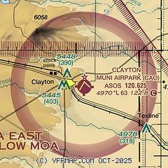
| Sectional chart |
|---|
|
| Airport distance calculator |
|---|
|
|
| Sunrise and sunset |
|---|
|
Times for 25-Jul-2026
| | Local
(UTC-6) | | Zulu
(UTC) |
|---|
| Morning civil twilight | | 05:25 | | 11:25 |
| Sunrise | | 05:54 | | 11:54 |
| Sunset | | 20:04 | | 02:04 |
| Evening civil twilight | | 20:33 | | 02:33 |
|
| Current date and time |
|---|
| Zulu (UTC) | 25-Jul-2026 13:06:58 |
|---|
| Local (UTC-6) | 25-Jul-2026 07:06:58 |
|---|
|
| METAR |
|---|
| KCAO | 251255Z AUTO 35007KT 10SM CLR 27/12 A3019 RMK AO2 SLP133 T02670122
|
|
| TAF |
|---|
KDHT
39nm SE | 251120Z 2512/2612 VRB05KT P6SM BKN250 FM252000 15010G20KT P6SM SCT080 FM260200 18009KT P6SM SCT100
|
|
| NOTAMs |
|---|
NOTAMs are issued by the DoD/FAA and will open in a separate window not controlled by AirNav.
|
|

