FAA INFORMATION EFFECTIVE 19 FEBRUARY 2026
Location
| FAA Identifier: | CBM |
| Lat/Long: | 33-38-42.6300N 088-26-45.3100W
33-38.710500N 088-26.755167W
33.6451750,-88.4459194
(estimated) |
| Elevation: | 218 ft. / 66.4 m (surveyed) |
| Variation: | 00E (1995) |
| From city: | 9 miles N of COLUMBUS, MS |
| Time zone: | UTC -6 (UTC -5 during Daylight Saving Time) |
| Zip code: | 39701 |
Airport Operations
| Airport use: | Private use. Permission required prior to landing |
| Activation date: | 01/1943 |
| Control tower: | yes |
| ARTCC: | MEMPHIS CENTER |
| FSS: | GREENWOOD FLIGHT SERVICE STATION |
| NOTAMs facility: | CBM (NOTAM-D service available) |
| Attendance: | MON-FRI 1300-0100Z++, ALL SUN 1800-2300Z++
CLSD SAT AND HOLS; ADNL DATES / TIMES INTMT BY NOTAM. |
| Pattern altitude: | OVERHEAD - 1700 FT, RECTANGULAR - 1200 FT, COPTER - 700 FT. |
| Wind indicator: | yes |
| Segmented circle: | no |
| Lights: | SS-SR |
| Beacon: | white-green (lighted land airport)
Operates sunset to sunrise. |
Airport Communications
| ATIS: | 115.2T 273.5 |
| WX ASOS: | 354.6 |
| COLUMBUS GROUND: | 121.9 275.8 [0700-1900 MON-FRI, 1200-1700 SUN, CLSD SAT & HOLS.] |
| COLUMBUS TOWER: | 126.65 379.925 [0700-1900 MON-FRI, 1200-1700 SUN, CLSD SAT & HOLS.] |
| COLUMBUS APPROACH: | 126.075 ;310-090 132.025 ;090-165 133.25 134.55 ;090-165 135.6 ;165-310 239.25 ;310-090 263.15 307.8 323.275 ;165-310 350.3 ;090-165 [0700-1900 MON-FRI, 1200-1700 SUN, CLSD SAT & HOLS.] |
| MEMPHIS ARTCC APPROACH: | 121.075 291.65 ;090-165 317.5 [1900-0700 MON-FRI, 1700-1200 SUN, SAT & HOLS.] |
| COLUMBUS DEPARTURE: | 132.025 134.55 263.15 350.3 [0700-1900 MON-FRI, 1200-1700 SUN, CLSD SAT & HOLS.] |
| MEMPHIS ARTCC DEPARTURE: | 135.6 291.65 ;090-165 323.275 [1900-0700 MON-FRI, 1700-1200 SUN, SAT & HOLS.] |
| CLEARANCE DELIVERY: | 269.55 |
| CLASS C: | 126.075 ;310-090 132.025 ;090-165 134.55 ;090-165 135.6 ;165-310 239.25 ;310-090 263.15 323.275 ;165-310 350.3 ;090-165 350.3 |
| CLASS C/S: | 121.075 291.65 ;090-165 317.5 |
| EMERG: | 121.5 243.0 |
| OPS: | 291.65 ;MOA |
| PMSV METRO: | 354.6 |
| PTD: | 376.0 |
| SOF: | 252.1 |
| WX AWOS-3PT at GTR (14 nm SW): | 126.375 (662-328-7798) |
| WX AWOS-3P at M40 (14 nm N): | 118.475 (662-369-3498) |
- APCH/DEP SVC PRVDD BY MEMPHIS ARTCC ON FREQS 127.1 (COLUMBUS RCAG) WHEN COLUMBUS APCH CTL CLSD.
- PMSV METRO: WX OPR H24 0600Z++ MON THRU 0100Z+ SAT, 1600-2300Z++ SUN, CLSD SAT AND HOLS; OPR HRS MAY VARY BY LCL FLYING SKED. CTC C662-434-2992/DSN 742-2992. REMOTE BRIEFING SVC AVBL BARKSDALE AFB FR 26 OWS DSN 331-2651/2/3, C318-529-2651/2/3.
- APP CON (126.075 239.25 310-090) (132.025 291.65 090-165) (135.6 323.275 1650310) (133.25 307.8 ARR)
- MONOPULSE SECONDARY SURVEILLANCE RADAR (ASR/MSSR) SYSTEM.
Nearby radio navigation aids
| VOR radial/distance | | VOR name | | Freq | | Var |
|---|
| CBM at field | | CALEDONIA VORTAC | | 115.20 | | 00E |
| IGBr015/10.2 | | BIGBEE VORTAC | | 116.20 | | 04E |
| OTBr149/38.9 | | TUPELO VOR/DME | | 109.80 | | 04E |
Airport Services
| Fuel available: | A++ |
| Parking: | hangars |
| Airframe service: | MAJOR |
| Powerplant service: | MAJOR |
| Bottled oxygen: | LOW |
| Bulk oxygen: | LOW |
Runway Information
Runway 13C/31C
| Dimensions: | 12004 x 300 ft. / 3659 x 91 m |
| Surface: | asphalt/concrete
CNTR 200 FT GROOVED CONC; 50 FT OUTSIDE PORTIONS ASPHALT. |
| Weight bearing capacity: | |
| Runway edge lights: | high intensity |
| RUNWAY 13C | | RUNWAY 31C |
| Latitude: | 33-39.317167N | | 33-37.917667N |
| Longitude: | 088-27.503333W | | 088-25.830000W |
| Elevation: | 192.7 ft. | | 212.9 ft. |
| Traffic pattern: | left | | left |
| Runway heading: | 135 | | 315 |
| Markings: | precision, in good condition | | precision, in good condition |
| Visual slope indicator: | 4-light PAPI on left (3.00 degrees glide path) | | 4-light PAPI on left (3.00 degrees glide path) |
| Approach lights: | ALSF1: standard 2,400 foot high intensity approach lighting system with centerline sequenced flashers (category I) | | ALSF1: standard 2,400 foot high intensity approach lighting system with centerline sequenced flashers (category I) |
| Runway end identifier lights: | no | | no |
| Touchdown point: | yes, no lights | | yes, no lights |
| Instrument approach: | ILS | | ILS |
Runway 13L/31R
| Dimensions: | 8001 x 150 ft. / 2439 x 46 m |
| Surface: | asphalt/concrete
FIRST 1000 FT 13L-31R IS CONC, MID 6000 FT ASPH. |
| Weight bearing capacity: | |
| Runway edge lights: | high intensity |
| RUNWAY 13L | | RUNWAY 31R |
| Latitude: | 33-39.322333N | | 33-38.389667N |
| Longitude: | 088-27.105167W | | 088-25.989667W |
| Elevation: | 191.6 ft. | | 216.4 ft. |
| Traffic pattern: | left | | left |
| Runway heading: | 135 | | 315 |
| Markings: | NSTD, in good condition | | NSTD, in good condition |
| Visual slope indicator: | 4-light PAPI on left (3.00 degrees glide path) | | 4-light PAPI on left (3.00 degrees glide path) |
| Touchdown point: | yes, no lights | | yes, no lights |
Runway 13R/31L
| Dimensions: | 6320 x 175 ft. / 1926 x 53 m |
| Surface: | concrete
CONTR 75 FT GROOVED CONC; OUTSIDE PORTIONS ASPHALT. |
| Weight bearing capacity: | |
| Runway edge lights: | medium intensity |
| RUNWAY 13R | | RUNWAY 31L |
| Latitude: | 33-39.070500N | | 33-38.333667N |
| Longitude: | 088-27.626500W | | 088-26.745500W |
| Elevation: | 190.3 ft. | | 204.2 ft. |
| Traffic pattern: | left | | left |
| Runway heading: | 135 | | 315 |
| Markings: | NSTD, in good condition | | NSTD, in good condition |
| Visual slope indicator: | 4-light PAPI on left (3.00 degrees glide path) | | 4-light PAPI on left (3.00 degrees glide path) |
| Touchdown point: | yes, no lights | | yes, no lights |
Airport Ownership and Management from official FAA records
| Ownership: | U.S. Air Force |
| Owner: | USAF
HQ 14TH FTW ATC,COLUMBUS AFB
COLUMBUS, MS 39701 |
| Manager: | AIRFIELD MANAGER
HQ 14TH FTW ATC,COLUMBUS AFB
COLUMBUS, MS 39701-5000
Phone 662-434-2993
COLUMBUS APPROACH POINT OF CONTACT: KEVIN BILLINGSLEY. |
Additional Remarks
| E60-31C | MA-1A CHAG (111 FT OVRN) |
| E60-13L | BAK-15 CHAG (130 FT OVRN) |
| E60-31R | BAK-15 CHAG (130 FT OVRN) |
| E60-13C | MA-1A CHAG (111 FT OVRN) |
| - | EXP 30 MIN LDG DELAY DUR STU FLYING PERIODS. |
| - | CAUTION: DO NOT MISTAKE PARL TWY TO RWY 13R/31L FOR RWY. 13R/31L ADDN MKGS FOR BASE ASGN T-38 EMERG LNDG ONLY. RWY 13R OVERRUN 1000 FT FULL STRENGTH PAVEMENT, RY 31L OVERRUN 1635 FT FULL STRENGTH PAVEMENT. EXER CAUTION WHEN BRAKING WET; PONDING COND EXISTS ON ASPHALT PORTIONS OF ALL RWYS. |
| - | A-GEAR: MA-1A CONT RAISED POSN ON DEP END OF CNTR RWY, DOWN AND DISCONNECTED ON APCH END. BAK-15 RWY 13L-31R UNCERTIFIED/UNSVC. SUN ONLY. |
| - | ALL ACFT NOT DEPARTING ON AN ESTABLISHED DP, EXPECT TO FLY RWY HEADING UNTIL 10 DME OR 4000 FT MSL. |
| - | ALL FIXED WING ACFT PLAN TO ARR, TERMINATE & DEP IAW IFR UNLESS PPR FOR VFR FLT PLAN. |
| - | JASU: 1(MD-3) 2(A/M32A-86) 3(AM32-95). |
| - | FLUID: LPOX LOX. |
| - | OIL: O-148-156; SOAP-RESULTS AVBL MON-FRI. |
| - | CAUTION: ACFT WITHIN RWY SUPERVISORY UNIT (RSU) PRACTICE AREA ARE NOT CLASS C PARTICIPANTS. RSU PRACTICE AREAS ARE DEFINED IN FLIP AP/1 SUPPLEMENTARY ARPT RMK. |
| - | EXP PRECISION FULL STOP LDG TO RWY 13C-31C. |
| - | MISC: AUGMENTED WX OBSN VIEW LTD, RSTD FR 140-320 DEG BY FLIGHTLINE FAC AND TREES. |
| - | RSTD: PPR; ONLY 4 ACFT PER HR DUR STU TRNG. OVERHEAD APCH NOT AUTH DUR STU TRNG OPR. RWY 13R/31L FOR LCL USE ONLY DUR STU TRNG. ALL TSNT AIRCREWS CK IN WITH BASE OPS. EXP RADAR VECTOR FOR FULL STOP LDG DUR STU TRNG. ALT RSTD FOR VMC DEP ACFT. |
| - | MISC: STD USAF RSRS APPLIED. ATC PERS IAW THE COOPERATIVE WX WATCH (CCW) WILL ALERT PERS ON ANY UNREPORTED WX COND THAT COULD AFCT FLT SAFETY. |
| - | MISC: AUTO AN/FMQ-19 ASOS IN USE H24 LCTD NEAR GS RWY 13C-31C. AUGMENTED/BACKED UP AN/FMQ-19 ASOS IN USE WHEN REQ DUR OPR HR AND FOR RESOURCE PROTECTION. OPR HR MAY VARY WITH LCL FLYING SCHED. |
| - | MISC: AFLD OPS DOES NOT HAVE ABILITY TO STORE COMSEC. CTC COMD POST; DSN 742-7020, C662-434-7020 FOR COMSEC STORAGE. |
| - | CAUTION: BOTH APN EDGES INSIDE REQUIRE 25 FT FROM TWY CNTRLN. T-1 RAMP E OF CTL TWR IS LCTD IN RWY 31L CLEAR ZONE. NUMEROUS SIGNS ON AIRFIELD ARE OUTSIDE DIST AND SITING CRITERIA. ACFT WITHIN RWY SUPERVISORY UNIT (RSU) PRACTICE AREA ARE NOT CLASS C PARTICIPANTS. POTENTIAL TRANSIT/DIVERT UAS OPS WITHIN TRML AREA. |
| - | COMD POST - 251.25. |
| - | CAUTION: BASH-PHASE II BIRD ACT FOR MIGRATORY SEASON SEP-APR. PEAK ACT OCCURS WITHIN 1 HR OF SR AND SS, SEE AP/1 CHAP 3 FOR MORE INFO. OBTAIN CURRENT BIRD WATCH CONDITIONS ON ATIS. |
| - | NO PRKG FOR ACFT EXCEEDING 100000 LBS GWT EXC AIREVAC. |
| - | CAUTION: BA LESS THAN EXP, REDUCED RWY SKID RESISTANCE AND HI POTENTIAL FOR HYDROPLANING ALL RWY WHEN WET. RWY CC NOT RPTD. USE CAUTION AT INT TWY G AND C, AND J AND C. |
| - | CAUTION: RWY 13R RWY HOLD SIGN AT TWY A NOT COLLOCATED WITH PAVEMENT MRK. |
| - | PMSV METRO WX OPR H24 EXC HOL, OT BY NOTAM. CTC 662-434-2992/DSN 742-2992. |
| - | SERVICE-TRAN ALERT: TRAN OPR 1300-2300Z++ WKD; NO TRAN SVC SUN WO PRIOR CDN; CLSD SAT & HOL. OT BY NOTAM. |
| - | MISC: LTD HGR SPACE AVBL APR-DEC. FIRST 1000 FT RWY 13L-31R IS CONCRETE, MID 6000 FT IS ASPHALT. RWY 13R-31L IS GROOVED CONCRETE. |
| - | CAUTION: UNCTL VEH TFC ON TWY AND RAMPS. |
| - | SIMULATED FLAME OUTS NOT AUTHORIZED. |
| - | NS ABTMT: QUIET HRS DLY 0400-1200Z++. |
Instrument Procedures
NOTE: All procedures below are presented as PDF files. If you need a reader for these files, you should download the free Adobe Reader.NOT FOR NAVIGATION. Please procure official charts for flight.
FAA instrument procedures published for use from 19 February 2026 at 0901Z to 19 March 2026 at 0900Z.
Other nearby airports with instrument procedures:
KUBS - Columbus-Lowndes County Airport (11 nm S)
M83 - McCharen Field Airport (12 nm W)
KGTR - Golden Triangle Regional Airport (14 nm SW)
M40 - Monroe County Airport (14 nm N)
M51 - Oktibbeha Airport (15 nm SW)
|
|

Road maps at:
MapQuest
Bing
Google
| Aerial photo |
|---|

|
| Sectional chart |
|---|
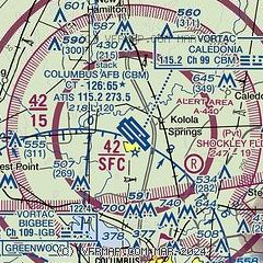
|
 Download PDF
of official airport diagram from the FAA
| Airport distance calculator |
|---|
|
|
| Sunrise and sunset |
|---|
|
Times for 13-Mar-2026
| | Local
(UTC-5) | | Zulu
(UTC) |
|---|
| Morning civil twilight | | 06:43 | | 11:43 |
| Sunrise | | 07:08 | | 12:08 |
| Sunset | | 18:59 | | 23:59 |
| Evening civil twilight | | 19:24 | | 00:24 |
|
| Current date and time |
|---|
| Zulu (UTC) | 13-Mar-2026 16:01:36 |
|---|
| Local (UTC-5) | 13-Mar-2026 11:01:36 |
|---|
|
| METAR |
|---|
| KCBM | 131555Z 21010KT 10SM CLR 15/00 A3014 RMK AO2A SLP209 T01540004 $
|
KGTR
13nm SW | 131556Z 21008KT 10SM CLR 14/01 A3018 RMK AO2 SLP223 T01440011 $
|
KM40
14nm N | 131555Z AUTO 19008KT 10SM CLR 15/M06 A3019 RMK AO2
|
|
| TAF |
|---|
| KCBM | 131100Z 1311/1415 13005KT 9999 SKC 510204 QNH3008INS BECMG 1313/1314 18010G15KT 9999 SKC 510204 QNH3005INS BECMG 1320/1321 24009KT 9999 SKC 510204 QNH3003INS TX20/1320Z TN04/1311Z
|
KGTR
13nm SW | 131120Z 1312/1412 19007KT P6SM SKC
|
|
| NOTAMs |
|---|
NOTAMs are issued by the DoD/FAA and will open in a separate window not controlled by AirNav.
|
|


