FAA INFORMATION EFFECTIVE 07 AUGUST 2025
Location
| FAA Identifier: | M51 |
| Lat/Long: | 33-29-51.6439N 088-40-53.1189W
33-29.860732N 088-40.885315W
33.4976789,-88.6814219
(estimated) |
| Elevation: | 250 ft. / 76 m (estimated) |
| Variation: | 02E (1990) |
| From city: | 7 miles NE of STARKVILLE, MS |
| Time zone: | UTC -5 (UTC -6 during Standard Time) |
| Zip code: | 39759 |
Airport Operations
| Airport use: | Open to the public |
| Activation date: | 01/1943 |
| Control tower: | no |
| ARTCC: | MEMPHIS CENTER |
| FSS: | GREENWOOD FLIGHT SERVICE STATION |
| NOTAMs facility: | GWO (NOTAM-D service available) |
| Attendance: | SAT-SUN 24 HOURS/DAY |
| Wind indicator: | yes |
| Segmented circle: | no |
Airport Communications
| CTAF/UNICOM: | 122.8 |
| COLUMBUS APPROACH: | 135.6 |
| COLUMBUS DEPARTURE: | 135.6 |
| WX AWOS-3PT at GTR (5 nm SE): | 126.375 (662-328-7798) |
| WX AWOS-3PT at STF (9 nm SW): | 118.975 (662-323-4966) |
| WX ASOS at CBM (15 nm NE): | 354.6 |
- UNICOM OTS INDEFLY.
- APCH/DEP SVC PRVDD BY MEMPHIS ARTCC (COLUMBUS RCAG) ON FREQS 127.1/269.4 WHEN COLUMBUS APCH CTL CLSD.
Nearby radio navigation aids
| VOR radial/distance | | VOR name | | Freq | | Var |
|---|
| IGBr271/8.4 | | BIGBEE VORTAC | | 116.20 | | 04E |
| CBMr235/14.9 | | CALEDONIA VORTAC | | 115.20 | | 00E |
Airport Services
| Parking: | hangars and tiedowns |
| Bottled oxygen: | NONE |
| Bulk oxygen: | NONE |
Runway Information
Runway 14/32
| Dimensions: | 2600 x 150 ft. / 792 x 46 m |
| Surface: | turf, in fair condition |
| Operational restrictions: | MKD BY MOWING & WHITE JUGS 75 FT APART. |
| RUNWAY 14 | | RUNWAY 32 |
| Latitude: | 33-30.032000N | | 33-29.695167N |
| Longitude: | 088-41.065000W | | 088-40.748333W |
| Elevation: | 245.8 ft. | | 247.0 ft. |
| Traffic pattern: | left | | left |
| Runway heading: | 140 magnetic, 142 true | | 320 magnetic, 322 true |
| Markings: | NSTD, in fair condition | | NSTD, in fair condition |
| Touchdown point: | yes, no lights | | yes, no lights |
| Obstructions: | 77 ft. trees, 1800 ft. from runway, 23:1 slope to clear | | 56 ft. trees, 1700 ft. from runway, 30:1 slope to clear |
Runway 1/19
| Dimensions: | 2237 x 150 ft. / 682 x 46 m |
| Surface: | turf, in fair condition |
| Operational restrictions: | MKD BY MOWING & WHITE JUGS 75 FT APART. |
| RUNWAY 1 | | RUNWAY 19 |
| Latitude: | 33-29.675000N | | 33-30.039833N |
| Longitude: | 088-40.893000W | | 088-40.828000W |
| Elevation: | 248.5 ft. | | 250.0 ft. |
| Traffic pattern: | left | | left |
| Runway heading: | 006 magnetic, 008 true | | 186 magnetic, 188 true |
| Markings: | NSTD, in fair condition | | NSTD, in fair condition |
| Touchdown point: | yes, no lights | | yes, no lights |
| Obstructions: | 17 ft. trees, 400 ft. from runway, 130 ft. left of centerline, 23:1 slope to clear | | 59 ft. trees, 1350 ft. from runway, 22:1 slope to clear |
Airport Ownership and Management from official FAA records
| Ownership: | Privately-owned |
| Owner: | DOUG CAMP
1606 CAMP AIRPORT RD
STARKVILLE, MS 39759
Phone 662-431-2345 |
| Manager: | DOUG CAMP
1606 CAMP AIRPORT RD
STARKVILLE, MS 39759
Phone 662-341-2345 |
Additional Remarks
| - | FOR CD CTC MEMPHIS ARTCC AT 901-368-8453/8449. |
Instrument Procedures
NOTE: All procedures below are presented as PDF files. If you need a reader for these files, you should download the free Adobe Reader.NOT FOR NAVIGATION. Please procure official charts for flight.
FAA instrument procedures published for use from 07 August 2025 at 0901Z to 04 September 2025 at 0900z.
IAPs - Instrument Approach Procedures |
|---|
| RNAV (GPS)-A | |
download (167KB) |
| NOTE: Special Take-Off Minimums/Departure Procedures apply | |
download (150KB) |
Other nearby airports with instrument procedures:
M83 - McCharen Field Airport (5 nm N)
KGTR - Golden Triangle Regional Airport (5 nm SE)
KSTF - George M Bryan Airport (9 nm SW)
KCBM - Columbus Air Force Base (15 nm NE)
KUBS - Columbus-Lowndes County Airport (15 nm E)
|
|

Road maps at:
MapQuest
Bing
Google
| Aerial photo |
|---|
WARNING: Photo may not be current or correct

Do you have a better or more recent aerial photo of Oktibbeha Airport that you would like to share? If so, please send us your photo.
|
| Sectional chart |
|---|
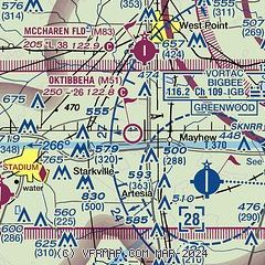
|
| Airport distance calculator |
|---|
|
|
| Sunrise and sunset |
|---|
|
Times for 29-Aug-2025
| | Local
(UTC-5) | | Zulu
(UTC) |
|---|
| Morning civil twilight | | 06:02 | | 11:02 |
| Sunrise | | 06:28 | | 11:28 |
| Sunset | | 19:24 | | 00:24 |
| Evening civil twilight | | 19:49 | | 00:49 |
|
| Current date and time |
|---|
| Zulu (UTC) | 30-Aug-2025 03:18:48 |
|---|
| Local (UTC-5) | 29-Aug-2025 22:18:48 |
|---|
|
| METAR |
|---|
KGTR
6nm SE | 300256Z AUTO 15007KT 10SM CLR 23/21 A3000 RMK AO2 SLP158 T02280206 53005
|
KSTF
9nm SW | 300255Z AUTO 00000KT 10SM FEW055 21/21 A2997 RMK AO2
|
KCBM
14nm NE | 292255Z AUTO 10004KT 10SM SCT065 31/15 A2994 RMK AO2 SLP139 T03060150 $
|
|
| TAF |
|---|
KGTR
6nm SE | 291728Z 2918/3018 09007KT P6SM SCT250 FM301200 02003KT 6SM BR BKN250
|
KCBM
14nm NE | 282350Z 2823/2923 VRB06KT 9999 SCT045 OVC060 QNH3006INS TEMPO 2823/2902 9000 -SHRA BECMG 2901/2902 03005KT 9999 SCT065 BKN120 QNH3002INS TEMPO 2909/2915 VRB04KT 8000 BR BECMG 2915/2916 09006KT 9999 BKN040 QNH2993INS TX25/2823Z TN15/2909Z LAST NO AMDS AFT 2823 NEXT 0209
|
|
| NOTAMs |
|---|
NOTAMs are issued by the DoD/FAA and will open in a separate window not controlled by AirNav.
|
|

