FAA INFORMATION EFFECTIVE 22 JANUARY 2026
Location
| FAA Identifier: | CDH |
| Lat/Long: | 33-37-22.1000N 092-45-48.2000W
33-37.368333N 092-45.803333W
33.6228056,-92.7633889
(estimated) |
| Elevation: | 129.6 ft. / 39.5 m (surveyed) |
| Variation: | 02E (2010) |
| From city: | 5 miles NE of CAMDEN, AR |
| Time zone: | UTC -6 (UTC -5 during Daylight Saving Time) |
| Zip code: | 71701 |
Airport Operations
| Airport use: | Open to the public |
| Activation date: | 10/1944 |
| Control tower: | no |
| ARTCC: | FORT WORTH CENTER |
| FSS: | JONESBORO FLIGHT SERVICE STATION |
| NOTAMs facility: | JBR (NOTAM-D service available) |
| Attendance: | MON-FRI 0800-1630
FOR SVC AFT HRS CALL 870-818-3408. |
| Wind indicator: | lighted |
| Segmented circle: | yes |
| Lights: | ACTVT REIL RWY 01 & 19; PAPI RWY 01 & 19; MIRL RWY 01/19 - CTAF. |
| Beacon: | white-green (lighted land airport)
Operates sunset to sunrise. |
Airport Communications
| CTAF/UNICOM: | 122.7 |
| WX AWOS-3: | 125.2 (870-574-1011) |
- APCH/DEP CTL SVC PRVDD BY FORT WORTH ARTCC (ZFW) ON FREQS 128.2/269.1 (EL DORADO RCAG).
Nearby radio navigation aids
| VOR radial/distance | | VOR name | | Freq | | Var |
|---|
| ELDr350/22.0 | | EL DORADO VOR/DME | | 115.50 | | 07E |
Airport Services
| Fuel available: | 100LL JET-A
100LL:FUEL AVBL SELF SERVE 24 HRS WITH CREDIT CARD (100LL & JET A). |
| Parking: | hangars and tiedowns |
| Airframe service: | NONE |
| Powerplant service: | NONE |
| Bottled oxygen: | NONE |
Runway Information
Runway 1/19
| Dimensions: | 6502 x 100 ft. / 1982 x 30 m |
| Surface: | asphalt/grooved, in good condition |
| Weight bearing capacity: | | Single wheel: | 86.0 | | Double wheel: | 112.0 | | Double tandem: | 180.0 |
|
| Runway edge lights: | medium intensity |
| RUNWAY 1 | | RUNWAY 19 |
| Latitude: | 33-36.838518N | | 33-37.897157N |
| Longitude: | 092-45.904683W | | 092-45.702703W |
| Elevation: | 122.9 ft. | | 129.6 ft. |
| Traffic pattern: | left | | left |
| Runway heading: | 007 magnetic, 009 true | | 187 magnetic, 189 true |
| Markings: | nonprecision, in fair condition | | nonprecision, in fair condition |
| Visual slope indicator: | 2-light PAPI on left (3.00 degrees glide path)
UNUSBL BYD 5.0 DEGS LEFT AND RIGHT OF CNTRLN. | | 2-light PAPI on left (3.00 degrees glide path)
UNUSBL BYD 4.0 DEGS RIGHT OF CNTRLN. |
| Runway end identifier lights: | yes | | yes |
| Touchdown point: | yes, no lights | | yes, no lights |
| Obstructions: | 45 ft. trees, 1050 ft. from runway, 360 ft. right of centerline, 18:1 slope to clear | | 55 ft. trees, 600 ft. from runway, 250 ft. right of centerline, 7:1 slope to clear |
Airport Ownership and Management from official FAA records
| Ownership: | Publicly-owned |
| Owner: | CITY OF CAMDEN
PO BOX 278
CAMDEN, AR 71711
Phone 870-836-6436 |
| Manager: | KYLE GATLING
255 AIRPORT RD
CAMDEN, AR 71701
Phone 870-818-3408 |
Additional Remarks
| - | FOR CD CTC FORT WORTH ARTCC AT 817-858-7584. |
Instrument Procedures
NOTE: All procedures below are presented as PDF files. If you need a reader for these files, you should download the free Adobe Reader.NOT FOR NAVIGATION. Please procure official charts for flight.
FAA instrument procedures published for use from 22 January 2026 at 0901Z to 19 February 2026 at 0900z.
IAPs - Instrument Approach Procedures |
|---|
| RNAV (GPS) RWY 01 | |
download (223KB) |
| RNAV (GPS) RWY 19 | |
download (226KB) |
| NOTE: Special Alternate Minimums apply | |
download (123KB) |
| NOTE: Special Take-Off Minimums/Departure Procedures apply | |
download (391KB) |
Other nearby airports with instrument procedures:
KELD - South Arkansas Regional Airport at Goodwin Field (24 nm S)
KADF - Dexter B Florence Memorial Field Airport (32 nm NW)
KAGO - Ralph C Weiser Field Airport (33 nm SW)
3M9 - Warren Municipal Airport/John B Frazer Jr. Field (34 nm E)
M78 - Malvern Municipal Airport (43 nm N)
|
|

Road maps at:
MapQuest
Bing
Google
| Aerial photo |
|---|
WARNING: Photo may not be current or correct
 Photo courtesy of the Arkansas Department of Aeronautics
Taken in the Spring of 2007
Photo courtesy of the Arkansas Department of Aeronautics
Taken in the Spring of 2007
Do you have a better or more recent aerial photo of Harrell Field Airport that you would like to share? If so, please send us your photo.
|
| Sectional chart |
|---|
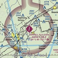
|
| Airport distance calculator |
|---|
|
|
| Sunrise and sunset |
|---|
|
Times for 02-Feb-2026
| | Local
(UTC-6) | | Zulu
(UTC) |
|---|
| Morning civil twilight | | 06:42 | | 12:42 |
| Sunrise | | 07:08 | | 13:08 |
| Sunset | | 17:42 | | 23:42 |
| Evening civil twilight | | 18:08 | | 00:08 |
|
| Current date and time |
|---|
| Zulu (UTC) | 02-Feb-2026 06:46:19 |
|---|
| Local (UTC-6) | 02-Feb-2026 00:46:19 |
|---|
|
| METAR |
|---|
| KCDH | 020635Z AUTO 00000KT 10SM CLR M03/M07 A3033 RMK AO2
|
|
| TAF |
|---|
KELD
25nm S | 020520Z 0206/0306 VRB03KT P6SM SKC FM021500 20005KT P6SM SKC FM021800 21009KT P6SM SKC FM030000 VRB03KT P6SM FEW250
|
|
| NOTAMs |
|---|
NOTAMs are issued by the DoD/FAA and will open in a separate window not controlled by AirNav.
|
|

