FAA INFORMATION EFFECTIVE 30 OCTOBER 2025
Location
| FAA Identifier: | CDI |
| Lat/Long: | 39-58-30.1000N 081-34-39.3000W
39-58.501667N 081-34.655000W
39.9750278,-81.5775833
(estimated) |
| Elevation: | 798.8 ft. / 243.5 m (surveyed) |
| Variation: | 07W (1990) |
| From city: | 3 miles S of CAMBRIDGE, OH |
| Time zone: | UTC -5 (UTC -4 during Daylight Saving Time) |
| Zip code: | 43725 |
Airport Operations
| Airport use: | Open to the public |
| Activation date: | 09/1968 |
| Control tower: | no |
| ARTCC: | CLEVELAND CENTER |
| FSS: | CLEVELAND FLIGHT SERVICE STATION |
| NOTAMs facility: | CDI (NOTAM-D service available) |
| Attendance: | MON-SAT 0800-1700 |
| Wind indicator: | lighted |
| Segmented circle: | yes |
| Lights: | ACTVT REIL RWY 04 & 22; MIRL RWY 04/22 - CTAF. PAPI RWY 04 & 22 OPR CONSLY. |
| Beacon: | white-green (lighted land airport)
Operates sunset to sunrise. |
Airport Communications
| CTAF/UNICOM: | 123.075 |
| WX AWOS-3: | 118.525 (740-435-0086) |
| WX ASOS at ZZV (15 nm W): | 127.0 (740-453-8139) |
- APCH/DEP SVC PRVDD BY INDIANAPOLIS ARTCC (ZID) ON FREQS 124.45/323.275 (ZANESVILLE RCAG) WEST SIDE OPS.
- APCH/DEP SVC PRVDD BY CLEVELAND ARTCC (ZOB) ON FREQS 126.95/239.3 (BELMONT RCAG) EAST SIDE OPS.
Nearby radio navigation aids
| VOR radial/distance | | VOR name | | Freq | | Var |
|---|
| JPUr347/33.4 | | PARKERSBURG VOR/DME | | 114.45 | | 03W |
| AIRr273/35.0 | | BELLAIRE VOR/DME | | 117.10 | | 07W |
| NDB name | | Hdg/Dist | | Freq | | Var | | ID |
|---|
| CADIZ | | 246/30.3 | | 239 | | 07W | | CFX | -.-. ..-. -..- |
Airport Services
| Fuel available: | 100LL JET-A+
A+:JET A AVBL FULL SVC ONLY. FOR SVC AFT HRS CALL AMGR.
100LL:100LL AVBL H24 SELF SVC VIA CREDIT CARD; FULL SVC AVBL WHEN ATNDD. |
| Parking: | hangars and tiedowns |
| Airframe service: | NONE |
| Powerplant service: | NONE |
| Bottled oxygen: | NONE |
| Bulk oxygen: | NONE |
Runway Information
Runway 4/22
| Dimensions: | 4298 x 75 ft. / 1310 x 23 m |
| Surface: | asphalt/grooved, in good condition |
| Weight bearing capacity: | |
| Runway edge lights: | medium intensity |
| RUNWAY 4 | | RUNWAY 22 |
| Latitude: | 39-58.205932N | | 39-58.798763N |
| Longitude: | 081-34.906525W | | 081-34.403597W |
| Elevation: | 798.5 ft. | | 798.5 ft. |
| Traffic pattern: | left | | left |
| Runway heading: | 040 magnetic, 033 true | | 220 magnetic, 213 true |
| Displaced threshold: | 400 ft. | | no |
| Markings: | nonprecision, in good condition | | nonprecision, in good condition |
| Visual slope indicator: | 4-light PAPI on left (4.00 degrees glide path)
PAPI UNUSBL BYD 4 DEGS LEFT & 8 DEGS RIGHT OF CNTRLN. | | 4-light PAPI on right (3.55 degrees glide path)
PAPI UNUSBL BYD 8 DEGS LEFT & 4 DEGS RIGHT OF CNTRLN. |
| Runway end identifier lights: | yes | | yes |
| Touchdown point: | yes, no lights | | yes, no lights |
| Instrument approach: | | | LOC/DME |
| Obstructions: | 50 ft. pline, 795 ft. from runway, 205 ft. left of centerline, 11:1 slope to clear
APCH SLP 10:1 TO DTHR OVR 65 FT TREE, 692 FT DIST, 330 FT L. | | 15 ft. road, 355 ft. from runway, 270 ft. left of centerline, 10:1 slope to clear |
Airport Ownership and Management from official FAA records
| Ownership: | Publicly-owned |
| Owner: | CAMBRIDGE AREA RGNL ARPT AUTH
PO BOX 73
CAMBRIDGE, OH 43725-0073
Phone 740-432-3726 |
| Manager: | DAVID GAL
9732 BRICK CHURCH RD
CAMBRIDGE, OH 43725-9420
Phone 740-260-7558
CDIAIRPORT@GMAIL.COM. |
Additional Remarks
| - | DEER, BIRDS, & OTR WILDLIFE INVOF ARPT. |
| - | RAMP FEES FOR COML ACFT EXC FLT TRG ACFT, CDI BASED ACFT, OVNGT HNGR STAY, FUEL PURCHASE OF 25 GALS OR TOP OFF. |
| - | FOR CD CTC CLEVELAND ARTCC AT 440-774-0226/0490. |
Instrument Procedures
NOTE: All procedures below are presented as PDF files. If you need a reader for these files, you should download the free Adobe Reader.NOT FOR NAVIGATION. Please procure official charts for flight.
FAA instrument procedures published for use from 30 October 2025 at 0901Z to 27 November 2025 at 0900Z.
IAPs - Instrument Approach Procedures |
|---|
| RNAV (GPS) RWY 04 | |
download (190KB) |
| RNAV (GPS) RWY 22 | |
download (205KB) |
| NOTE: Special Alternate Minimums apply | |
download (131KB) |
| NOTE: Special Take-Off Minimums/Departure Procedures apply | |
download (232KB) |
Other nearby airports with instrument procedures:
I10 - Noble County Airport (11 nm S)
KZZV - Zanesville Municipal Airport (15 nm W)
6G5 - Barnesville/Bradfield Airport (18 nm E)
I40 - Richard Downing Airport (24 nm NW)
4G5 - Monroe County Airport (25 nm SE)
|
|

Road maps at:
MapQuest
Bing
Google
| Aerial photo |
|---|
WARNING: Photo may not be current or correct

Do you have a better or more recent aerial photo of Cambridge Municipal Airport that you would like to share? If so, please send us your photo.
|
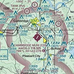
| Sectional chart |
|---|
|
CAUTION: Diagram may not be current

| Airport distance calculator |
|---|
|
|
| Sunrise and sunset |
|---|
|
Times for 22-Nov-2025
| | Local
(UTC-5) | | Zulu
(UTC) |
|---|
| Morning civil twilight | | 06:51 | | 11:51 |
| Sunrise | | 07:20 | | 12:20 |
| Sunset | | 17:05 | | 22:05 |
| Evening civil twilight | | 17:34 | | 22:34 |
|
| Current date and time |
|---|
| Zulu (UTC) | 22-Nov-2025 20:09:02 |
|---|
| Local (UTC-5) | 22-Nov-2025 15:09:02 |
|---|
|
| METAR |
|---|
| KCDI | 221955Z AUTO 00000KT 10SM SCT038 11/03 A3001 RMK AO2 T01100033
|
KZZV
15nm W | 221953Z AUTO VRB04KT 10SM SCT035 11/02 A3001 RMK AO2 SLP162 T01060022
|
|
| TAF |
|---|
KZZV
15nm W | 221723Z 2218/2318 33005KT P6SM BKN020 FM222000 33003KT P6SM SCT030 BKN250 FM230600 VRB02KT P6SM BKN080 FM231400 27010G19KT P6SM BKN060
|
|
| NOTAMs |
|---|
NOTAMs are issued by the DoD/FAA and will open in a separate window not controlled by AirNav.
|
|


