FAA INFORMATION EFFECTIVE 16 APRIL 2026
Location
| FAA Identifier: | CLK |
| Lat/Long: | 35-32-17.7812N 098-55-58.0388W
35-32.296353N 098-55.967313W
35.5382726,-98.9327886
(estimated) |
| Elevation: | 1615.5 ft. / 492.4 m (surveyed) |
| Variation: | 07E (2000) |
| From city: | 3 miles NE of CLINTON, OK |
| Time zone: | UTC -5 (UTC -6 during Standard Time) |
| Zip code: | 73601 |
Airport Operations
| Airport use: | Open to the public |
| Activation date: | 08/1948 |
| Control tower: | no |
| ARTCC: | FORT WORTH CENTER |
| FSS: | MC ALESTER FLIGHT SERVICE STATION |
| NOTAMs facility: | CLK (NOTAM-D service available) |
| Attendance: | 0800-1700 |
| Wind indicator: | lighted |
| Segmented circle: | yes |
| Lights: | ACTVT & INCR INTST REIL RWY 17 & 35 - CTAF. PAPI RWY 17 & 35 ON CONSLY. MIRL RWY 17/35; TWY LGTS ON LOW INTST DUSK-DAWN; INCR INTST - CTAF. |
| Beacon: | white-green (lighted land airport)
Operates sunset to sunrise. |
Airport Communications
| CTAF/UNICOM: | 122.8 |
| WX AWOS-3: | 119.225 (580-323-8477) |
| WX AWOS-3PT at OJA (13 nm E): | 118.575 (580-772-7020) |
| WX ASOS at CSM (18 nm SW): | 118.450 (580-562-4811) |
- APCH/DEP CTL SVC PRVDD BY FORT WORTH ARTCC (ZFW) ON FREQS 128.4/269.37 (CLINTON-SHERMAN RCAG).
Nearby radio navigation aids
| VOR radial/distance | | VOR name | | Freq | | Var |
|---|
| BFVr031/22.5 | | BURNS FLAT VORTAC | | 110.00 | | 05E |
Airport Services
| Fuel available: | 100LL JET-A+
100LL:100LL FUEL AVBL 24 HRS - SELF SVC. |
| Parking: | hangars and tiedowns |
| Airframe service: | MAJOR |
| Powerplant service: | MAJOR |
| Bottled oxygen: | NONE |
| Bulk oxygen: | NONE |
Runway Information
Runway 17/35
| Dimensions: | 4305 x 72 ft. / 1312 x 22 m |
| Surface: | asphalt, in excellent condition |
| Weight bearing capacity: | |
| Runway edge lights: | medium intensity |
| RUNWAY 17 | | RUNWAY 35 |
| Latitude: | 35-32.581532N | | 35-31.872002N |
| Longitude: | 098-55.931575W | | 098-55.918708W |
| Elevation: | 1608.0 ft. | | 1595.7 ft. |
| Traffic pattern: | left | | left |
| Runway heading: | 172 magnetic, 179 true | | 352 magnetic, 359 true |
| Markings: | nonprecision, in good condition | | nonprecision, in good condition |
| Visual slope indicator: | 4-light PAPI on left (3.00 degrees glide path) | | 4-light PAPI on right (3.00 degrees glide path) |
| Runway end identifier lights: | yes | | yes |
| Touchdown point: | yes, no lights | | yes, no lights |
Runway 13/31
| Dimensions: | 1348 x 245 ft. / 411 x 75 m |
| Surface: | turf, in good condition |
| Runway edge markings: | ORANGE BARRELS MKD BOUNDARIES. |
| RUNWAY 13 | | RUNWAY 31 |
| Latitude: | 35-32.600457N | | 35-32.436715N |
| Longitude: | 098-56.193935W | | 098-56.010052W |
| Elevation: | 1599.4 ft. | | 1612.5 ft. |
| Traffic pattern: | left | | left |
| Runway heading: | 130 magnetic, 137 true | | 310 magnetic, 317 true |
| Markings: | none, in poor condition | | none, in poor condition |
| Touchdown point: | yes, no lights | | yes, no lights |
Airport Ownership and Management from official FAA records
| Ownership: | Publicly-owned |
| Owner: | CITY OF CLINTON
BOX 1177
CLINTON, OK 73601
Phone 580-323-0217 |
| Manager: | TRACY YODER
10200 N. AIRPORT RD.
CLINTON, OK 73601
Phone 580-323-5782
AFT HRS FONE NR - 580-445-1379. |
Additional Remarks
| - | FOR CD CTC FORT WORTH ARTCC AT 817-858-7584. |
Instrument Procedures
NOTE: All procedures below are presented as PDF files. If you need a reader for these files, you should download the free Adobe Reader.NOT FOR NAVIGATION. Please procure official charts for flight.
FAA instrument procedures published for use from 16 April 2026 at 0901Z to 14 May 2026 at 0900Z.
IAPs - Instrument Approach Procedures |
|---|
| RNAV (GPS) RWY 17 | |
download (241KB) |
| RNAV (GPS) RWY 35 | |
download (247KB) |
| NOTE: Special Alternate Minimums apply | |
download (75KB) |
| NOTE: Special Take-Off Minimums/Departure Procedures apply | |
download |
Other nearby airports with instrument procedures:
KOJA - Weatherford Stafford Airport (13 nm E)
1O4 - Thomas Municipal Airport (15 nm NE)
KCSM - Clinton/Sherman Airport (18 nm SW)
KELK - Elk City Regional Business Airport (23 nm W)
2O8 - Hinton Municipal Airport (29 nm E)
|
|

Road maps at:
MapQuest
Bing
Google
| Aerial photo |
|---|
WARNING: Photo may not be current or correct

Do you have a better or more recent aerial photo of Clinton Regional Airport that you would like to share? If so, please send us your photo.
|
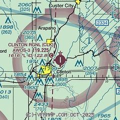
| Sectional chart |
|---|
|
| Airport distance calculator |
|---|
|
|
| Sunrise and sunset |
|---|
|
Times for 12-May-2026
| | Local
(UTC-5) | | Zulu
(UTC) |
|---|
| Morning civil twilight | | 06:06 | | 11:06 |
| Sunrise | | 06:34 | | 11:34 |
| Sunset | | 20:30 | | 01:30 |
| Evening civil twilight | | 20:58 | | 01:58 |
|
| Current date and time |
|---|
| Zulu (UTC) | 12-May-2026 21:03:51 |
|---|
| Local (UTC-5) | 12-May-2026 16:03:51 |
|---|
|
| METAR |
|---|
| KCLK | 122035Z AUTO 19009G17KT 10SM CLR 30/10 A3004 RMK AO2
|
KOJA
13nm E | 122030Z AUTO 19013KT 10SM CLR 30/12 A3003 RMK AO2 T03030122
|
KCSM
17nm SW | 122053Z 20013G22KT 10SM CLR 31/12 A3002 RMK AO2 PK WND 18027/2037 SLP145 6//// T03110117 56020 PNO $
|
|
| TAF |
|---|
KCSM
17nm SW | 121720Z 1218/1318 20016G26KT P6SM SKC FM130000 17011KT P6SM SKC FM130600 04008KT P6SM SCT150 FM131500 09008KT P6SM SKC
|
|
| NOTAMs |
|---|
NOTAMs are issued by the DoD/FAA and will open in a separate window not controlled by AirNav.
|
|

