FAA INFORMATION EFFECTIVE 14 MAY 2026
Location
| FAA Identifier: | EAG |
| Lat/Long: | 42-42-35.7000N 093-54-58.0000W
42-42.595000N 093-54.966667W
42.7099167,-93.9161111
(estimated) |
| Elevation: | 1132.3 ft. / 345.1 m (surveyed) |
| Variation: | 03E (1995) |
| From city: | 3 miles N of EAGLE GROVE, IA |
| Time zone: | UTC -5 (UTC -6 during Standard Time) |
| Zip code: | 50533 |
Airport Operations
| Airport use: | Open to the public |
| Activation date: | 11/1948 |
| Control tower: | no |
| ARTCC: | MINNEAPOLIS CENTER |
| FSS: | FORT DODGE FLIGHT SERVICE STATION |
| NOTAMs facility: | FOD (NOTAM-D service available) |
| Attendance: | UNATNDD |
| Wind indicator: | lighted |
| Segmented circle: | no |
| Lights: | ACTVT MIRL RY 13/31 & REIL RYS 13 & 31 - CTAF. |
| Beacon: | white-green (lighted land airport)
Operates sunset to sunrise. |
Airport Communications
| CTAF/UNICOM: | 122.8 |
| WX AWOS-3 at CAV (7 nm E): | 126.575 (515-532-3515) |
| WX AWOS-3PT at FOD (15 nm SW): | 118.775 (515-955-5490) |
| WX AWOS-3 at EBS (17 nm S): | 127.825 (515-832-2794) |
- APCH/DEP SVC PRVDD BY MINNEAPOLIS ARTCC ON FREQS 134.0/288.3 (FORT DODGE RCAG).
Nearby radio navigation aids
| VOR radial/distance | | VOR name | | Freq | | Var |
|---|
| MCWr222/34.6 | | MASON CITY VOR/DME | | 114.90 | | 06E |
Airport Services
| Fuel available: | 100LL |
| Parking: | hangars and tiedowns |
| Airframe service: | NONE |
| Powerplant service: | NONE |
| Bottled oxygen: | NONE |
| Bulk oxygen: | NONE |
Runway Information
Runway 13/31
| Dimensions: | 3500 x 60 ft. / 1067 x 18 m |
| Surface: | concrete, in fair condition |
| Runway edge lights: | medium intensity |
| RUNWAY 13 | | RUNWAY 31 |
| Latitude: | 42-42.815325N | | 42-42.398215N |
| Longitude: | 093-55.262920W | | 093-54.723785W |
| Elevation: | 1130.9 ft. | | 1128.6 ft. |
| Traffic pattern: | left | | left |
| Runway heading: | 133 magnetic, 136 true | | 313 magnetic, 316 true |
| Displaced threshold: | 119 ft. | | no |
| Markings: | nonprecision, in fair condition | | nonprecision, in fair condition |
| Runway end identifier lights: | yes
REIL OTS INDEFLY. | | yes |
| Touchdown point: | yes, no lights | | yes, no lights |
| Obstructions: | 15 ft. road, 200 ft. from runway, 120 ft. right of centerline
+15 ROAD 184' FM THR 120' R. | | 46 ft. tree, 1429 ft. from runway, 19 ft. left of centerline, 26:1 slope to clear |
Runway 1/19
| Dimensions: | 2389 x 120 ft. / 728 x 37 m |
| Surface: | turf, in fair condition |
| Runway edge markings: | 01/19 MKD WITH YELLOW CONES. |
| Operational restrictions: | CLSD NOV-APR. |
| RUNWAY 1 | | RUNWAY 19 |
| Latitude: | 42-42.389140N | | 42-42.766428N |
| Longitude: | 093-55.004563W | | 093-54.854413W |
| Elevation: | 1128.8 ft. | | 1128.0 ft. |
| Traffic pattern: | left | | left |
| Runway heading: | 013 magnetic, 016 true | | 193 magnetic, 196 true |
| Touchdown point: | yes, no lights | | yes, no lights |
Airport Ownership and Management from official FAA records
| Ownership: | Publicly-owned |
| Owner: | CITY OF EAGLE GROVE
210 EAST BROADWAY
EAGLE GROVE, IA 50533
Phone 515-448-4343
DON GARRETT ARPT CMSN CHMN; PHONE 515-448-4073. |
| Manager: | BRYCE DAVIS
2355 HWY 17
EAGLE GROVE, IA 50533
Phone 515-851-5826 |
Additional Remarks
| - | FOR CD CTC MINNEAPOLIS ARTCC AT 651-463-5588. |
Instrument Procedures
NOTE: All procedures below are presented as PDF files. If you need a reader for these files, you should download the free Adobe Reader.NOT FOR NAVIGATION. Please procure official charts for flight.
FAA instrument procedures published for use from 14 May 2026 at 0901Z to 11 June 2026 at 0900Z.
IAPs - Instrument Approach Procedures |
|---|
| RNAV (GPS) RWY 13 **CHANGED** | |
download (181KB) |
| RNAV (GPS) RWY 31 **CHANGED** | |
download (197KB) |
| NOTE: Special Take-Off Minimums/Departure Procedures apply | |
download (158KB) |
Other nearby airports with instrument procedures:
KCAV - Clarion Municipal Airport (7 nm E)
KFOD - Fort Dodge Regional Airport (15 nm SW)
KEBS - Webster City Municipal Airport (17 nm S)
KAXA - Algona Municipal Airport (27 nm NW)
KHPT - Hampton Municipal Airport (30 nm E)
|
|

Road maps at:
MapQuest
Bing
Google
| Aerial photo |
|---|
WARNING: Photo may not be current or correct
 Photo by Iden Mersereau
Photo taken 08-Jul-2018
looking northeast.
Photo by Iden Mersereau
Photo taken 08-Jul-2018
looking northeast.
Do you have a better or more recent aerial photo of Eagle Grove Municipal Airport that you would like to share? If so, please send us your photo.
|
| Sectional chart |
|---|
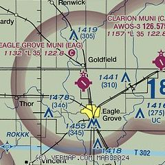
|
| Airport distance calculator |
|---|
|
|
| Sunrise and sunset |
|---|
|
Times for 21-May-2026
| | Local
(UTC-5) | | Zulu
(UTC) |
|---|
| Morning civil twilight | | 05:15 | | 10:15 |
| Sunrise | | 05:49 | | 10:49 |
| Sunset | | 20:36 | | 01:36 |
| Evening civil twilight | | 21:09 | | 02:09 |
|
| Current date and time |
|---|
| Zulu (UTC) | 21-May-2026 23:06:13 |
|---|
| Local (UTC-5) | 21-May-2026 18:06:13 |
|---|
|
| METAR |
|---|
KCAV
7nm E | 212255Z AUTO 10016KT 10SM OVC075 14/06 A3014 RMK A01
|
KFOD
15nm SW | 212256Z AUTO 12011G16KT 10SM OVC060 14/07 A3014 RMK AO2 SLP222 T01390067 $
|
KEBS
18nm S | 212255Z AUTO 09012KT 10SM BKN060 OVC100 14/08 A3012 RMK AO2
|
|
| TAF |
|---|
KFOD
15nm SW | 211728Z 2118/2218 12009G16KT P6SM OVC080 FM220200 10008KT P6SM OVC050 FM221100 11010KT P6SM SCT027 BKN045 PROB30 2212/2216 6SM -SHRA OVC025
|
|
| NOTAMs |
|---|
NOTAMs are issued by the DoD/FAA and will open in a separate window not controlled by AirNav.
|
|

