FAA INFORMATION EFFECTIVE 22 JANUARY 2026
Location
| FAA Identifier: | EBS |
| Lat/Long: | 42-26-11.0887N 093-52-08.2813W
42-26.184812N 093-52.138022W
42.4364135,-93.8689670
(estimated) |
| Elevation: | 1121.5 ft. / 341.8 m (surveyed) |
| Variation: | 03E (1995) |
| From city: | 3 miles SW of WEBSTER CITY, IA |
| Time zone: | UTC -6 (UTC -5 during Daylight Saving Time) |
| Zip code: | 50595 |
Airport Operations
| Airport use: | Open to the public |
| Activation date: | 05/1945 |
| Control tower: | no |
| ARTCC: | MINNEAPOLIS CENTER |
| FSS: | FORT DODGE FLIGHT SERVICE STATION |
| NOTAMs facility: | EBS (NOTAM-D service available) |
| Attendance: | SAT-SUN ON CALL, ALL MON-FRI 0800-1700
ON CALL MON-FRI AFT HRS AND ALL DAY SAT & SUN 515-832-3723. |
| Wind indicator: | lighted |
| Segmented circle: | no |
| Lights: | ACTVT REIL RWY 14 & 32; PAPI RWY 14 & 32; MIRL RWY 14/32 - CTAF. |
| Beacon: | white-green (lighted land airport)
Operates sunset to sunrise. |
Airport Communications
| CTAF/UNICOM: | 122.8 |
| WX AWOS-3: | 127.825 (515-832-2794) |
| WX AWOS-3PT at FOD (16 nm NW): | 118.775 (515-955-5490) |
| WX AWOS-3 at CAV (19 nm N): | 126.575 (515-532-3515) |
- APCH/DEP SVC PRVDD BY MINNEAPOLIS ARTCC ON FREQS 134.0/288.3 (FORT DODGE RCAG).
Airport Services
| Fuel available: | 100LL JET-A |
| Parking: | hangars and tiedowns |
| Airframe service: | MAJOR |
| Powerplant service: | MAJOR |
| Bottled oxygen: | NONE |
| Bulk oxygen: | NONE |
Runway Information
Runway 14/32
| Dimensions: | 3851 x 75 ft. / 1174 x 23 m |
| Surface: | concrete, in good condition |
| Weight bearing capacity: | | PCN 5 /R/C/W/U | | Single wheel: | 15.0 |
|
| Runway edge lights: | medium intensity |
| RUNWAY 14 | | RUNWAY 32 |
| Latitude: | 42-26.409392N | | 42-25.896647N |
| Longitude: | 093-52.376028W | | 093-51.872733W |
| Elevation: | 1105.7 ft. | | 1121.4 ft. |
| Traffic pattern: | left | | left |
| Runway heading: | 141 magnetic, 144 true | | 321 magnetic, 324 true |
| Markings: | nonprecision, in fair condition | | nonprecision, in fair condition |
| Visual slope indicator: | 4-light PAPI on left (3.00 degrees glide path) | | 4-light PAPI on left (3.00 degrees glide path) |
| Runway end identifier lights: | yes | | yes |
| Touchdown point: | yes, no lights | | yes, no lights |
| Obstructions: | 19 ft. road, 503 ft. from runway, 290 ft. left of centerline, 15:1 slope to clear | | none |
Runway 5/23
| Dimensions: | 2663 x 90 ft. / 812 x 27 m |
| Surface: | turf, in fair condition |
| Runway edge markings: | 05/23 THRS & EDGES MKD WITH CONES. |
| Operational restrictions: | CLSD NOV-APR. |
| RUNWAY 5 | | RUNWAY 23 |
| Latitude: | 42-26.088017N | | 42-26.373557N |
| Longitude: | 093-52.382222W | | 093-51.933272W |
| Elevation: | 1118.9 ft. | | 1107.6 ft. |
| Traffic pattern: | left | | left |
| Runway heading: | 046 magnetic, 049 true | | 226 magnetic, 229 true |
| Touchdown point: | yes, no lights | | yes, no lights |
| Obstructions: | 6 ft. crops, 210 ft. from runway, 45 ft. left of centerline, 35:1 slope to clear | | none |
Airport Ownership and Management from official FAA records
| Ownership: | Publicly-owned |
| Owner: | CITY OF WEBSTER CITY
400 2ND ST.
WEBSTER CITY, IA 50595-0217
Phone 515-832-5701
CHAIRMAN ARPT CMSN SCOTT BARGFREDE |
| Manager: | MIKE LUEDTKE
1524 - 240TH ST
WEBSTER CITY, IA 50595
Phone 515-832-3723
EMAIL ADDRESS: INFO@STORMFLYINGSERVICE.COM |
Additional Remarks
| - | FOR CD CTC MINNEAPOLIS ARTCC AT 651-463-5588. |
Instrument Procedures
NOTE: All procedures below are presented as PDF files. If you need a reader for these files, you should download the free Adobe Reader.NOT FOR NAVIGATION. Please procure official charts for flight.
FAA instrument procedures published for use from 22 January 2026 at 0901Z to 19 February 2026 at 0900z.
IAPs - Instrument Approach Procedures |
|---|
| RNAV (GPS) RWY 14 **CHANGED** | |
download (219KB) |
| RNAV (GPS) RWY 32 **CHANGED** | |
download (224KB) |
| NOTE: Special Alternate Minimums apply | |
download (147KB) |
| NOTE: Special Take-Off Minimums/Departure Procedures apply | |
download |
Other nearby airports with instrument procedures:
KFOD - Fort Dodge Regional Airport (16 nm NW)
KEAG - Eagle Grove Municipal Airport (17 nm N)
KCAV - Clarion Municipal Airport (19 nm N)
KBNW - Boone Municipal Airport (23 nm S)
KIFA - Iowa Falls Municipal Airport (27 nm E)
|
|

Road maps at:
MapQuest
Bing
Google
| Aerial photo |
|---|
WARNING: Photo may not be current or correct
 Photo by Iden Mersereau
Photo taken 08-Jul-2018
looking east.
Photo by Iden Mersereau
Photo taken 08-Jul-2018
looking east.
Do you have a better or more recent aerial photo of Webster City Municipal Airport that you would like to share? If so, please send us your photo.
|
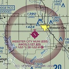
| Sectional chart |
|---|
|
| Airport distance calculator |
|---|
|
|
| Sunrise and sunset |
|---|
|
Times for 17-Feb-2026
| | Local
(UTC-6) | | Zulu
(UTC) |
|---|
| Morning civil twilight | | 06:42 | | 12:42 |
| Sunrise | | 07:10 | | 13:10 |
| Sunset | | 17:49 | | 23:49 |
| Evening civil twilight | | 18:18 | | 00:18 |
|
| Current date and time |
|---|
| Zulu (UTC) | 17-Feb-2026 09:36:55 |
|---|
| Local (UTC-6) | 17-Feb-2026 03:36:55 |
|---|
|
| METAR |
|---|
| KEBS | 170915Z AUTO 11006KT 10SM CLR 02/02 A2977 RMK AO2
|
KFOD
14nm NW | 170856Z AUTO 10004KT 10SM CLR 03/02 A2980 RMK AO2 SLP106 T00280017 56012 $
|
KCAV
19nm N | 170915Z AUTO 11006KT 10SM FEW036 FEW042 03/03 A2979 RMK A01
|
|
| TAF |
|---|
KFOD
14nm NW | 170520Z 1706/1806 08003KT P6SM BKN200 FM171500 12012KT P6SM BKN100 FM171700 15017G24KT P6SM SCT025 BKN090 FM180100 17013G21KT P6SM SCT025 BKN040 WS020/17050KT PROB30 1801/1804 4SM -RA BKN200 FM180500 22011KT P6SM SCT050 WS020/26040KT
|
|
| NOTAMs |
|---|
NOTAMs are issued by the DoD/FAA and will open in a separate window not controlled by AirNav.
|
|

