FAA INFORMATION EFFECTIVE 19 MARCH 2026
Location
| FAA Identifier: | BNW |
| Lat/Long: | 42-02-58.4000N 093-50-51.4000W
42-02.973333N 093-50.856667W
42.0495556,-93.8476111
(estimated) |
| Elevation: | 1160.3 ft. / 353.7 m (surveyed) |
| Variation: | 03E (1995) |
| From city: | 2 miles SE of BOONE, IA |
| Time zone: | UTC -5 (UTC -6 during Standard Time) |
| Zip code: | 50036 |
Airport Operations
| Airport use: | Open to the public |
| Activation date: | 04/1949 |
| Control tower: | no |
| ARTCC: | MINNEAPOLIS CENTER |
| FSS: | FORT DODGE FLIGHT SERVICE STATION |
| NOTAMs facility: | BNW (NOTAM-D service available) |
| Attendance: | 0800-1700
AFT HR - 515-291-5094 OR 515-460-3892. |
| Wind indicator: | lighted |
| Segmented circle: | no |
| Lights: | ACTVT REIL RWY 15; PAPI RWY 15 & 33; MIRL RWY 15/33 - CTAF. |
| Beacon: | white-green (lighted land airport)
Operates sunset to sunrise. |
Airport Communications
| CTAF/UNICOM: | 123.0 |
| WX AWOS-3: | 120.925 (515-432-9042) |
| DES MOINES APPROACH: | 123.9 |
| DES MOINES DEPARTURE: | 123.9 |
| WX ASOS at AMW (11 nm E): | 132.025 (515-233-2611) |
| WX AWOS-3 at PRO (19 nm SW): | 118.0 (515-465-2269) |
Nearby radio navigation aids
| VOR radial/distance | | VOR name | | Freq | | Var |
|---|
| TNUr293/36.6 | | NEWTON VOR/DME | | 112.50 | | 03E |
| DSMr339/37.8 | | DES MOINES VORTAC | | 117.50 | | 07E |
Airport Services
| Fuel available: | 100LL JET-A MOGAS |
| Parking: | hangars and tiedowns |
| Airframe service: | MINOR |
| Powerplant service: | MINOR |
Runway Information
Runway 15/33
| Dimensions: | 4808 x 75 ft. / 1465 x 23 m |
| Surface: | concrete, in good condition |
| Weight bearing capacity: | | PCN 6 /R/D/W/U | | Single wheel: | 30.0 |
|
| Runway edge lights: | medium intensity |
| RUNWAY 15 | | RUNWAY 33 |
| Latitude: | 42-03.260742N | | 42-02.580127N |
| Longitude: | 093-51.050083W | | 093-50.507593W |
| Elevation: | 1137.7 ft. | | 1138.5 ft. |
| Traffic pattern: | left | | right |
| Runway heading: | 146 magnetic, 149 true | | 326 magnetic, 329 true |
| Displaced threshold: | 140 ft. | | no |
| Declared distances: | TORA:4807 TODA:4807 ASDA:4807 LDA:4667 | | TORA:4667 TODA:4807 ASDA:4807 LDA:4807 |
| Markings: | nonprecision, in good condition | | nonprecision, in good condition |
| Visual slope indicator: | 2-light PAPI on left (3.00 degrees glide path) | | 2-light PAPI on left (3.00 degrees glide path) |
| Runway end identifier lights: | yes | | no |
| Touchdown point: | yes, no lights | | yes, no lights |
| Obstructions: | 41 ft. tree, 1026 ft. from runway, 164 ft. left of centerline, 20:1 slope to clear
28:1 TO DTHR. | | none |
Runway 2/20
| Dimensions: | 3248 x 146 ft. / 990 x 45 m |
| Surface: | turf, in good condition |
| Runway edge markings: | YELLOW CONES. |
| RUNWAY 2 | | RUNWAY 20 |
| Latitude: | 42-02.809258N | | 42-03.292555N |
| Longitude: | 093-51.123872W | | 093-50.816692W |
| Elevation: | 1160.3 ft. | | 1136.2 ft. |
| Traffic pattern: | right | | left |
| Runway heading: | 022 magnetic, 025 true | | 202 magnetic, 205 true |
| Touchdown point: | yes, no lights | | yes, no lights |
| Obstructions: | none | | 50 ft. tree, 1430 ft. from runway, 28:1 slope to clear |
Airport Ownership and Management from official FAA records
| Ownership: | Publicly-owned |
| Owner: | CITY OF BOONE
923 8TH ST
BOONE, IA 50036
Phone 515-432-4211
JOE PUNDZAK |
| Manager: | DALE FARNHAM
424 CPL ROGER SNEDDEN DR
BOONE, IA 50036-7520
Phone 515-432-1018 |
Additional Remarks
| - | ANG OPS AV946-2388 - 515-432-6351 OR 36.7/142.6/143.25/231.55. |
| - | UNATNDD HOL & WHEN CEILING LESS THAN 400 FT OR VIS LESS THAN 1 MI. |
| - | FOR CD CTC DES MOINES ATCT AT 515-974- 8016. |
| - | FUEL AFT HR OR HOL - 515-291-5094. |
| - | RWY 02/20 NO SNOW REMOVAL, RWY CLSD WHEN SNOW CONDITIONS EXIST. |
Instrument Procedures
NOTE: All procedures below are presented as PDF files. If you need a reader for these files, you should download the free Adobe Reader.NOT FOR NAVIGATION. Please procure official charts for flight.
FAA instrument procedures published for use from 19 March 2026 at 0901Z to 16 April 2026 at 0900Z.
IAPs - Instrument Approach Procedures |
|---|
| RNAV (GPS) RWY 15 | |
download (234KB) |
| RNAV (GPS) RWY 33 | |
download (214KB) |
| NOTE: Special Alternate Minimums apply | |
download (40KB) |
| NOTE: Special Take-Off Minimums/Departure Procedures apply | |
download (432KB) |
Other nearby airports with instrument procedures:
KAMW - Ames Municipal Airport (11 nm E)
KPRO - Perry Municipal Airport (19 nm SW)
KEFW - Jefferson Municipal Airport (22 nm W)
KEBS - Webster City Municipal Airport (23 nm N)
KIKV - Ankeny Regional Airport (25 nm SE)
|
|

Road maps at:
MapQuest
Bing
Google
| Aerial photo |
|---|
WARNING: Photo may not be current or correct
 Taken in the Summer of 2008
Do you have a better or more recent aerial photo of Boone Municipal Airport that you would like to share? If so, please send us your photo.
|
| Sectional chart |
|---|
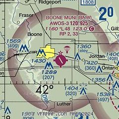
|
| Airport distance calculator |
|---|
|
|
| Sunrise and sunset |
|---|
|
Times for 31-Mar-2026
| | Local
(UTC-5) | | Zulu
(UTC) |
|---|
| Morning civil twilight | | 06:33 | | 11:33 |
| Sunrise | | 07:01 | | 12:01 |
| Sunset | | 19:39 | | 00:39 |
| Evening civil twilight | | 20:07 | | 01:07 |
|
| Current date and time |
|---|
| Zulu (UTC) | 31-Mar-2026 14:11:29 |
|---|
| Local (UTC-5) | 31-Mar-2026 09:11:29 |
|---|
|
| METAR |
|---|
| KBNW | 311355Z AUTO 35028KT 10SM OVC024 06/00 A2978 RMK AO2
|
KAMW
11nm E | 311353Z AUTO 35025G33KT 10SM BKN030 07/01 A2979 RMK AO2 PK WND 35033/1352 SLP085 T00720011
|
KPRO
19nm SW | 311355Z AUTO 35023G28KT 8SM OVC025 06/02 A2979 RMK AO2 PK WND 35028/1353 T00630017
|
|
| TAF |
|---|
KDSM
32nm S | 311126Z 3112/0112 20010G21KT P6SM BKN180 FM311500 34014G23KT P6SM BKN060 FM312000 01018G28KT P6SM BKN120 FM010300 03012KT P6SM BKN190
|
KFOD
32nm NW | 311126Z 3112/0112 36015G23KT P6SM SCT100 FM311500 36019G31KT P6SM BKN080 FM010400 03012KT P6SM BKN210
|
|
| NOTAMs |
|---|
NOTAMs are issued by the DoD/FAA and will open in a separate window not controlled by AirNav.
|
|

