FAA INFORMATION EFFECTIVE 09 JULY 2026
Location
| FAA Identifier: | EFW |
| Lat/Long: | 42-00-35.4000N 094-20-30.5000W
42-00.590000N 094-20.508333W
42.0098333,-94.3418056
(estimated) |
| Elevation: | 1047.3 ft. / 319.2 m (surveyed) |
| Variation: | 03E (2000) |
| From city: | 2 miles E of JEFFERSON, IA |
| Time zone: | UTC -5 (UTC -6 during Standard Time) |
| Zip code: | 50129 |
Airport Operations
| Airport use: | Open to the public |
| Activation date: | 06/1950 |
| Control tower: | no |
| ARTCC: | MINNEAPOLIS CENTER |
| FSS: | FORT DODGE FLIGHT SERVICE STATION |
| NOTAMs facility: | FOD (NOTAM-D service available) |
| Attendance: | UNATNDD |
| Wind indicator: | lighted |
| Segmented circle: | no |
| Lights: | DUSK-DAWN. ACTVT REIL RWY 14 & 32; MIRL RWY 14/32 - CTAF. PAPI RWY 14 & 32 OPR CONSLY |
| Beacon: | white-green (lighted land airport)
Operates sunset to sunrise. |
Airport Communications
| CTAF/UNICOM: | 122.8 |
| WX AWOS-3 at PRO (14 nm SE): | 118.0 (515-465-2269) |
- APCH/DEP SVC PRVDD BY MINNEAPOLIS ARTCC ON FREQS 134.0/288.3 (FORT DODGE RCAG).
Airport Services
| Fuel available: | 100LL |
| Parking: | hangars and tiedowns |
| Airframe service: | MINOR |
| Powerplant service: | MINOR |
| Bottled oxygen: | NONE |
| Bulk oxygen: | NONE |
Runway Information
Runway 14/32
| Dimensions: | 4100 x 75 ft. / 1250 x 23 m |
| Surface: | concrete, in good condition |
| Weight bearing capacity: | | PCN 6 /R/C/X/T | | Single wheel: | 11.0 |
|
| Runway edge lights: | medium intensity |
| RUNWAY 14 | | RUNWAY 32 |
| Latitude: | 42-00.827407N | | 42-00.289395N |
| Longitude: | 094-20.816352W | | 094-20.269772W |
| Elevation: | 1043.5 ft. | | 1047.3 ft. |
| Traffic pattern: | left | | left |
| Runway heading: | 140 magnetic, 143 true | | 320 magnetic, 323 true |
| Displaced threshold: | 100 ft. | | no |
| Markings: | nonprecision, in good condition | | nonprecision, in good condition |
| Visual slope indicator: | 2-light PAPI on left (3.00 degrees glide path) | | 2-light PAPI on left (3.00 degrees glide path) |
| Runway end identifier lights: | yes | | yes |
| Touchdown point: | yes, no lights | | yes, no lights |
| Obstructions: | 20 ft. road, 640 ft. from runway, 22:1 slope to clear | | none |
Runway 18/36
| Dimensions: | 1696 x 150 ft. / 517 x 46 m |
| Surface: | turf, in fair condition |
| Runway edge markings: | RUNWAY 18/36 MARKED WITH YELLOW CONES |
| RUNWAY 18 | | RUNWAY 36 |
| Latitude: | 42-00.804193N | | 42-00.531002N |
| Longitude: | 094-20.384977W | | 094-20.462280W |
| Elevation: | 1033.4 ft. | | 1038.0 ft. |
| Traffic pattern: | left | | left |
| Runway heading: | 189 magnetic, 192 true | | 009 magnetic, 012 true |
| Markings: | NSTD, in good condition | | NSTD, in good condition |
| Touchdown point: | yes, no lights | | yes, no lights |
| Obstructions: | 19 ft. road, 590 ft. from runway, 31:1 slope to clear | | 42 ft. pline, 1700 ft. from runway, 40:1 slope to clear |
Airport Ownership and Management from official FAA records
| Ownership: | Publicly-owned |
| Owner: | CITY OF JEFFERSON
CITY HALL
JEFFERSON, IA 50129
Phone 515-386-3111 |
| Manager: | SCOTT PETERSON
220 NORTH CHESTNUT STREET
JEFFERSON, IA 50129
Phone 515-386-3111
OR 515-386-2136 (POLICE) |
Additional Remarks
| - | RY 32 IS CALM WIND RY. |
| - | FOR CD CTC MINNEAPOLIS ARTCC AT 651-463-5588. |
Instrument Procedures
NOTE: All procedures below are presented as PDF files. If you need a reader for these files, you should download the free Adobe Reader.NOT FOR NAVIGATION. Please procure official charts for flight.
FAA instrument procedures published for use from 09 July 2026 at 0901Z to 06 August 2026 at 0900Z.
IAPs - Instrument Approach Procedures |
|---|
| RNAV (GPS) RWY 14 | |
download (229KB) |
| RNAV (GPS) RWY 32 | |
download (233KB) |
| NOTE: Special Take-Off Minimums/Departure Procedures apply | |
download (427KB) |
Other nearby airports with instrument procedures:
KPRO - Perry Municipal Airport (14 nm SE)
KGCT - Guthrie County Regional Airport (20 nm S)
KCIN - Arthur N Neu Airport (20 nm W)
KBNW - Boone Municipal Airport (22 nm E)
KADU - Audubon County Airport (32 nm SW)
|
|

Road maps at:
MapQuest
Bing
Google
| Aerial photo |
|---|

|
| Sectional chart |
|---|
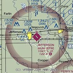
|
| Airport distance calculator |
|---|
|
|
| Sunrise and sunset |
|---|
|
Times for 29-Jul-2026
| | Local
(UTC-5) | | Zulu
(UTC) |
|---|
| Morning civil twilight | | 05:37 | | 10:37 |
| Sunrise | | 06:09 | | 11:09 |
| Sunset | | 20:39 | | 01:39 |
| Evening civil twilight | | 21:11 | | 02:11 |
|
| Current date and time |
|---|
| Zulu (UTC) | 30-Jul-2026 03:27:04 |
|---|
| Local (UTC-5) | 29-Jul-2026 22:27:04 |
|---|
|
| METAR |
|---|
KPRO
14nm SE | 300315Z AUTO 10003KT 10SM CLR 22/22 A2998 RMK AO2 T02240219 $
|
KCIN
19nm W | 300315Z AUTO 13004KT 8SM SCT050 SCT060 23/22 A3000 RMK AO2
|
|
| TAF |
|---|
KFOD
32nm N | 291732Z 2918/3018 14006KT P6SM SCT035 FM300300 15005KT P6SM FEW250 FM301400 17008KT P6SM FEW100 SCT200
|
|
| NOTAMs |
|---|
NOTAMs are issued by the DoD/FAA and will open in a separate window not controlled by AirNav.
|
|

