FAA INFORMATION EFFECTIVE 11 JUNE 2026
Location
| FAA Identifier: | AMW |
| Lat/Long: | 41-59-31.3570N 093-37-18.5550W
41-59.522617N 093-37.309250W
41.9920436,-93.6218208
(estimated) |
| Elevation: | 955.6 ft. / 291.3 m (surveyed) |
| Variation: | 03E (2000) |
| From city: | 2 miles SE of AMES, IA |
| Time zone: | UTC -5 (UTC -6 during Standard Time) |
| Zip code: | 50010 |
Airport Operations
| Airport use: | Open to the public |
| Activation date: | 08/1943 |
| Control tower: | no |
| ARTCC: | MINNEAPOLIS CENTER |
| FSS: | FORT DODGE FLIGHT SERVICE STATION |
| NOTAMs facility: | AMW (NOTAM-D service available) |
| Attendance: | DAWN-DUSK |
| Wind indicator: | lighted |
| Segmented circle: | yes |
| Lights: | ACTVT MALSR RWY 01; VASI RWYS 19; HIRL RWY 01/19 & MIRL RWY 13/31 - CTAF. |
| Beacon: | white-green (lighted land airport)
Operates sunset to sunrise. |
Airport Communications
| CTAF/UNICOM: | 122.7 |
| WX ASOS: | 132.025 (515-233-2611) |
| DES MOINES APPROACH: | 123.9 |
| DES MOINES DEPARTURE: | 123.9 |
| CLEARANCE DELIVERY: | 126.0 |
| WX AWOS-3 at BNW (11 nm W): | 120.925 (515-432-9042) |
| WX AWOS-3 at IKV (18 nm S): | 119.175 (515-965-5764) |
Nearby radio navigation aids
| VOR radial/distance | | VOR name | | Freq | | Var |
|---|
| TNUr296/26.1 | | NEWTON VOR/DME | | 112.50 | | 03E |
| DSMr355/33.3 | | DES MOINES VORTAC | | 117.50 | | 07E |
Airport Services
| Fuel available: | 100 JET-A |
| Parking: | hangars and tiedowns |
| Airframe service: | MAJOR |
| Powerplant service: | MAJOR |
| Bottled oxygen: | NONE |
Runway Information
Runway 1/19
| Dimensions: | 5701 x 100 ft. / 1738 x 30 m |
| Surface: | asphalt, in fair condition |
| Weight bearing capacity: | | PCN 32 /R/C/W/U | | Single wheel: | 30.0 | | Double wheel: | 38.0 |
|
| Runway edge lights: | high intensity |
| RUNWAY 1 | | RUNWAY 19 |
| Latitude: | 41-58.962055N | | 41-59.861562N |
| Longitude: | 093-37.485322W | | 093-37.125865W |
| Elevation: | 955.6 ft. | | 919.0 ft. |
| Traffic pattern: | right | | left |
| Runway heading: | 014 magnetic, 017 true | | 194 magnetic, 197 true |
| Markings: | precision, in good condition | | nonprecision, in good condition |
| Visual slope indicator: | | | 4-box VASI on left (4.00 degrees glide path) |
| Approach lights: | MALSR: 1,400 foot medium intensity approach lighting system with runway alignment indicator lights | | |
| Touchdown point: | yes, no lights | | yes, no lights |
| Instrument approach: | ILS/DME | | |
| Obstructions: | 78 ft. tree, 2380 ft. from runway, 350 ft. left of centerline, 27:1 slope to clear | | 87 ft. tree, 2400 ft. from runway, 345 ft. left of centerline, 25:1 slope to clear |
Runway 13/31
| Dimensions: | 3491 x 75 ft. / 1064 x 23 m |
| Surface: | concrete, in fair condition |
| Weight bearing capacity: | | PCN 10 /R/D/W/U | | Single wheel: | 30.0 |
|
| Runway edge lights: | medium intensity |
| RUNWAY 13 | | RUNWAY 31 |
| Latitude: | 41-59.910972N | | 41-59.496122N |
| Longitude: | 093-37.581898W | | 093-37.048540W |
| Elevation: | 925.9 ft. | | 920.2 ft. |
| Traffic pattern: | right | | left |
| Runway heading: | 133 magnetic, 136 true | | 313 magnetic, 316 true |
| Markings: | nonprecision, in good condition | | nonprecision, in good condition |
| Touchdown point: | yes, no lights | | yes, no lights |
| Obstructions: | 16 ft. tree, 320 ft. from runway, 164 ft. left of centerline, 7:1 slope to clear
32 FT TREE 124 FT FM RWY END AND 158 FT R ON APCH; CLNC SLOPE 1:1 | | 50 ft. tree, 1011 ft. from runway, 70 ft. right of centerline, 16:1 slope to clear |
Airport Ownership and Management from official FAA records
| Ownership: | Publicly-owned |
| Owner: | CITY OF AMES
515 CLARK AVE
AMES, IA 50010
Phone 515-239-5160 |
| Manager: | DAMION PREGITZER
515 CLARK AVE
AMES, IA 50010
Phone 515-239-5275 |
Additional Remarks
| - | BE ALERT FOR GLIDER & ULTRALIGHT OPNS INVOF ARPT. |
| - | BIRD AND DEER ACT ON & INVOF ARPT |
| - | RWY 01 IS CALM WIND RWY. |
| - | STADIUM WI 3 NM, CHECK FOR EVENTS. |
| - | COLD TEMPERATURE AIRPORT. ALTITUDE CORRECTION REQUIRED AT OR BELOW -26C. |
| - | FOR CD CTC DES MOINES ATCT ON 126.0 OR CALL 515-974- 8016. |
Instrument Procedures
NOTE: All procedures below are presented as PDF files. If you need a reader for these files, you should download the free Adobe Reader.NOT FOR NAVIGATION. Please procure official charts for flight.
FAA instrument procedures published for use from 11 June 2026 at 0901Z to 09 July 2026 at 0900z.
IAPs - Instrument Approach Procedures |
|---|
| ILS OR LOC RWY 01 **CHANGED** | |
download (219KB) |
| RNAV (GPS) RWY 01 **CHANGED** | |
download (202KB) |
| RNAV (GPS) RWY 13 **CHANGED** | |
download (197KB) |
| RNAV (GPS) RWY 19 **CHANGED** | |
download (232KB) |
| RNAV (GPS) RWY 31 **CHANGED** | |
download (202KB) |
| NOTE: Special Alternate Minimums apply | |
download (146KB) |
| NOTE: Special Take-Off Minimums/Departure Procedures apply | |
download (158KB) |
Other nearby airports with instrument procedures:
KBNW - Boone Municipal Airport (11 nm W)
KIKV - Ankeny Regional Airport (18 nm S)
KPRO - Perry Municipal Airport (26 nm W)
KDSM - Des Moines International Airport (28 nm S)
KEBS - Webster City Municipal Airport (29 nm N)
|
|

Road maps at:
MapQuest
Bing
Google
| Aerial photo |
|---|
WARNING: Photo may not be current or correct

Do you have a better or more recent aerial photo of Ames Municipal Airport that you would like to share? If so, please send us your photo.
|
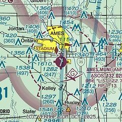
| Sectional chart |
|---|
|
CAUTION: Diagram may not be current

| Airport distance calculator |
|---|
|
|
| Sunrise and sunset |
|---|
|
Times for 02-Jul-2026
| | Local
(UTC-5) | | Zulu
(UTC) |
|---|
| Morning civil twilight | | 05:10 | | 10:10 |
| Sunrise | | 05:44 | | 10:44 |
| Sunset | | 20:53 | | 01:53 |
| Evening civil twilight | | 21:27 | | 02:27 |
|
| Current date and time |
|---|
| Zulu (UTC) | 03-Jul-2026 01:26:20 |
|---|
| Local (UTC-5) | 02-Jul-2026 20:26:20 |
|---|
|
| METAR |
|---|
| KAMW | 030053Z AUTO 14006KT 10SM TS FEW060 24/21 A2995 RMK AO2 LTG DSNT E-S RAE2356 SLP130 P0000 T02440211
|
KBNW
10nm W | 030115Z AUTO 09007KT 10SM FEW065 FEW080 25/22 A2993 RMK AO2
|
KIKV
19nm S | 030115Z AUTO 09012G19KT 10SM BKN045 OVC055 25/22 A2995 RMK AO2
|
|
| TAF |
|---|
KDSM
28nm S | 030012Z 0300/0324 21010KT P6SM SCT040 OVC120 FM030045 36012KT P6SM VCTS BKN050CB TEMPO 0301/0303 5SM -TSRA BKN040CB FM030300 17006KT P6SM SCT140 FM030800 17007KT P6SM OVC100 PROB30 0308/0312 5SM -TSRA BKN050CB FM031200 22010KT P6SM OVC100 PROB30 0312/0315 P6SM -SHRA BKN050 FM031700 19011KT P6SM FEW120
|
|
| NOTAMs |
|---|
NOTAMs are issued by the DoD/FAA and will open in a separate window not controlled by AirNav.
|
|


