FAA INFORMATION EFFECTIVE 25 DECEMBER 2025
Location
| FAA Identifier: | ETH |
| Lat/Long: | 45-46-49.8219N 096-32-37.6727W
45-46.830365N 096-32.627878W
45.7805061,-96.5437980
(estimated) |
| Elevation: | 1022.7 ft. / 311.7 m (surveyed) |
| Variation: | 05E (1995) |
| From city: | 3 miles SW of WHEATON, MN |
| Time zone: | UTC -6 (UTC -5 during Daylight Saving Time) |
| Zip code: | 56296 |
Airport Operations
| Airport use: | Open to the public |
| Activation date: | 04/1947 |
| Control tower: | no |
| ARTCC: | MINNEAPOLIS CENTER |
| FSS: | PRINCETON FLIGHT SERVICE STATION |
| NOTAMs facility: | ETH (NOTAM-D service available) |
| Attendance: | UNATNDD |
| Pattern altitude: | 1998.7 ft. MSL |
| Wind indicator: | lighted |
| Segmented circle: | no |
| Lights: | RY 16/34 MIRL PRESET TO LOW INTST. TO INCR INTST & ACTVT PAPI RY 16/34 - CTAF. |
| Beacon: | white-green (lighted land airport)
Operates sunset to sunrise. |
Airport Communications
| CTAF/UNICOM: | 122.8 |
| WX AWOS-3: | 118.775 (320-563-4975) |
- APCH/DEP SVC PRVDD BY MINNEAPOLIS ARTCC ON FREQS 126.1/269.2 (ALEXANDRIA RCAG).
Nearby radio navigation aids
| VOR radial/distance | | VOR name | | Freq | | Var |
|---|
| MOXr293/27.3 | | MORRIS VOR/DME | | 109.60 | | 05E |
| FFMr203/34.5 | | FERGUS FALLS VOR/DME | | 110.40 | | 05E |
Airport Services
| Parking: | tiedowns |
| Airframe service: | NONE |
| Powerplant service: | NONE |
| Bottled oxygen: | NONE |
| Bulk oxygen: | NONE |
Runway Information
Runway 16/34
| Dimensions: | 3298 x 75 ft. / 1005 x 23 m |
| Surface: | asphalt, in fair condition |
| Runway edge lights: | medium intensity |
| RUNWAY 16 | | RUNWAY 34 |
| Latitude: | 45-47.060393N | | 45-46.538790N |
| Longitude: | 096-32.672530W | | 096-32.459177W |
| Elevation: | 1017.2 ft. | | 1022.7 ft. |
| Traffic pattern: | left | | left |
| Runway heading: | 159 magnetic, 164 true | | 339 magnetic, 344 true |
| Markings: | nonprecision, in good condition | | nonprecision, in good condition |
| Visual slope indicator: | 2-light PAPI on left (3.00 degrees glide path) | | 2-light PAPI on left (3.00 degrees glide path)
PAPI 34 UNUSABLE BYD 8 DEGREE LEFT OF COURSE. |
| Runway end identifier lights: | no | | no |
| Touchdown point: | yes, no lights | | yes, no lights |
Runway 6/24
| Dimensions: | 1953 x 175 ft. / 595 x 53 m |
| Surface: | turf, in good condition |
| Runway edge markings: | MARKED WITH YELLOW CONES. |
| Operational restrictions: | NOT PLOWED WINTER MONTHS. |
| RUNWAY 6 | | RUNWAY 24 |
| Latitude: | 45-46.809870N | | 45-46.954792N |
| Longitude: | 096-32.937613W | | 096-32.527625W |
| Elevation: | 1016.0 ft. | | 1017.4 ft. |
| Traffic pattern: | left | | left |
| Runway heading: | 058 magnetic, 063 true | | 238 magnetic, 243 true |
| Runway end identifier lights: | no | | no |
| Touchdown point: | yes, no lights | | yes, no lights |
Airport Ownership and Management from official FAA records
| Ownership: | Publicly-owned |
| Owner: | CITY OF WHEATON
PO BOX 868, 104 9TH ST N
WHEATON, MN 56296
Phone 320-563-4110 |
| Manager: | AMY OLSON
PO BOX 868, 104 9TH ST N
WHEATON, MN 56296
Phone 320-563-4110 |
Additional Remarks
| - | FOR CD CTC MINNEAPOLIS ARTCC AT 651-463-5588. |
Instrument Procedures
NOTE: All procedures below are presented as PDF files. If you need a reader for these files, you should download the free Adobe Reader.NOT FOR NAVIGATION. Please procure official charts for flight.
FAA instrument procedures published for use from 25 December 2025 at 0901z to 22 January 2026 at 0900z.
IAPs - Instrument Approach Procedures |
|---|
| RNAV (GPS) RWY 16 | |
download (203KB) |
| RNAV (GPS) RWY 34 | |
download (215KB) |
| NOTE: Special Alternate Minimums apply | |
download (44KB) |
| NOTE: Special Take-Off Minimums/Departure Procedures apply | |
download (156KB) |
Other nearby airports with instrument procedures:
8D3 - Sisseton Municipal Airport (20 nm W)
Y63 - Elbow Lake Municipal/Pride of the Prairie Airport (26 nm NE)
KMOX - Morris Municipal Airport - Charlie Schmidt Field (28 nm SE)
KBWP - Harry Stern Airport (28 nm N)
KVVV - Ortonville Municipal Airport/Martinson Field (29 nm S)
|
|

Road maps at:
MapQuest
Bing
Google
| Aerial photo |
|---|
WARNING: Photo may not be current or correct

Do you have a better or more recent aerial photo of Wheaton Municipal Airport that you would like to share? If so, please send us your photo.
|
| Sectional chart |
|---|
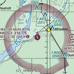
|
| Airport distance calculator |
|---|
|
|
| Sunrise and sunset |
|---|
|
Times for 10-Jan-2026
| | Local
(UTC-6) | | Zulu
(UTC) |
|---|
| Morning civil twilight | | 07:33 | | 13:33 |
| Sunrise | | 08:07 | | 14:07 |
| Sunset | | 17:01 | | 23:01 |
| Evening civil twilight | | 17:34 | | 23:34 |
|
| Current date and time |
|---|
| Zulu (UTC) | 10-Jan-2026 13:34:12 |
|---|
| Local (UTC-6) | 10-Jan-2026 07:34:12 |
|---|
|
| METAR |
|---|
KETH
5nm S | 101313Z AUTO 30011KT 10SM SCT080 OVC100 M08/M11 A3013 RMK AO2
|
K8D3
20nm W | 101256Z AUTO 32016G26KT M08/M12 A3011 RMK AO1 PK WND 32026/1244 SLP225 T10831122
|
|
| TAF |
|---|
KAXN
48nm E | 101120Z 1012/1112 29011KT P6SM SCT080 FM101400 30012G20KT P6SM OVC024 FM101800 31016G26KT P6SM OVC012 FM110400 31008KT P6SM BKN012
|
|
| NOTAMs |
|---|
NOTAMs are issued by the DoD/FAA and will open in a separate window not controlled by AirNav.
|
|

