FAA INFORMATION EFFECTIVE 25 DECEMBER 2025
Location
| FAA Identifier: | BWP |
| Lat/Long: | 46-14-39.4576N 096-36-25.7614W
46-14.657627N 096-36.429357W
46.2442938,-96.6071559
(estimated) |
| Elevation: | 968.2 ft. / 295 m (estimated) |
| Variation: | 05E (1995) |
| From city: | 1 mile S of WAHPETON, ND |
| Time zone: | UTC -6 (UTC -5 during Daylight Saving Time) |
| Zip code: | 58075 |
Airport Operations
| Airport use: | Open to the public |
| Activation date: | 11/1947 |
| Control tower: | no |
| ARTCC: | MINNEAPOLIS CENTER |
| FSS: | GRAND FORKS FLIGHT SERVICE STATION |
| NOTAMs facility: | GFK (NOTAM-D service available) |
| Attendance: | MON-FRI 0800-1700, ALL SAT-SUN ON CALL
FOR SVC AFT HRS CALL AMGR 701-361-0230. |
| Wind indicator: | lighted |
| Segmented circle: | yes |
| Lights: | MIRL RWY 15/33 PRESET LOW INTST TO INCR INTST & ACTVT REIL RWY 15 & 33; PAPI RWY 15 & 33 - CTAF. |
| Beacon: | white-green (lighted land airport)
Operates sunset to sunrise. |
Airport Communications
| CTAF/UNICOM: | 123.0 |
| WX AWOS-3: | 127.875 (701-642-9800) |
| WX AWOS-3PT at FFM (19 nm E): | 119.05 (218-736-7216) |
- COMMUNICATIONS PRVDD BY GRAND FORKS RADIO ON FREQ 122.4 (FARGO RCO).
- APCH/DEP SVC PRVDD BY MINNEAPOLIS ARTCC (ZMP) ON FREQ 127.35/278.3 (FARGO RCAG).
Nearby radio navigation aids
| VOR radial/distance | | VOR name | | Freq | | Var |
|---|
| FFMr257/18.9 | | FERGUS FALLS VOR/DME | | 110.40 | | 05E |
| FARr153/32.2 | | FARGO VOR/DME | | 116.20 | | 09E |
Airport Services
| Fuel available: | 100LL JET-A
100LL:100LL 24 HR SELF-SERVICE WITH CREDIT CARD. |
| Parking: | hangars and tiedowns |
| Airframe service: | MAJOR |
| Powerplant service: | MAJOR |
| Bottled oxygen: | NONE |
| Bulk oxygen: | NONE |
Runway Information
Runway 15/33
| Dimensions: | 5100 x 75 ft. / 1554 x 23 m |
| Surface: | concrete, in good condition |
| Weight bearing capacity: | |
| Runway edge lights: | medium intensity |
| RUNWAY 15 | | RUNWAY 33 |
| Latitude: | 46-15.035963N | | 46-14.269885N |
| Longitude: | 096-36.670913W | | 096-36.177880W |
| Elevation: | 968.1 ft. | | 966.2 ft. |
| Traffic pattern: | left | | left |
| Runway heading: | 151 magnetic, 156 true | | 331 magnetic, 336 true |
| Markings: | nonprecision, in fair condition | | nonprecision, in fair condition |
| Visual slope indicator: | 2-light PAPI on left (3.00 degrees glide path) | | 2-light PAPI on left (3.00 degrees glide path) |
| Runway end identifier lights: | yes | | yes |
| Touchdown point: | yes, no lights | | yes, no lights |
| Obstructions: | 45 ft. trees, 1400 ft. from runway, 80 ft. right of centerline, 26:1 slope to clear
32 FT TREES 1250 FT FROM THLD BOTH SIDES OF EXTDD CNTRLN APCH RATIO 32:1. | | 42 ft. trees, 1410 ft. from runway, 130 ft. both sides of centerline, 28:1 slope to clear |
Runway 3/21
| Dimensions: | 3254 x 150 ft. / 992 x 46 m |
| Surface: | turf, in good condition |
| Runway edge markings: | RWY 03/21 MKD WITH EDGE & CORNER DALGT METAL MKRS PAINTED ORANGE. |
| Operational restrictions: | RWY 03/21 CLSD WINTER MONTHS. |
| RUNWAY 3 | | RUNWAY 21 |
| Latitude: | 46-14.452868N | | 46-14.877125N |
| Longitude: | 096-36.672405W | | 096-36.201858W |
| Elevation: | 966.6 ft. | | 964.8 ft. |
| Traffic pattern: | left | | left |
| Runway heading: | 033 magnetic, 038 true | | 213 magnetic, 218 true |
| Touchdown point: | yes, no lights | | yes, no lights |
| Obstructions: | 49 ft. trees, 886 ft. from runway, 138 ft. both sides of centerline, 18:1 slope to clear | | none |
Airport Ownership and Management from official FAA records
| Ownership: | Publicly-owned |
| Owner: | WAHPETON ARPT AUTH
1251 PEGASUS ROAD
WAHPETON, ND 58075
Phone 701-642-5777 |
| Manager: | JON KLEIN
1251 PEGASUS ROAD
WAHPETON, ND 58075
Phone 701-642-5777
ADDNL PHONE 701-361-0230 OR CITY POLICE 701-642-7777. |
Additional Remarks
| - | RY 03 SAFETY AREA CULTIVATED UNEVEN DIRT, SOFT WHEN WET. |
| - | DEER AND BIRDS ON OR INVOF ARPT. |
| - | FOR CD CTC MINNEAPOLIS ARTCC AT 651-463-5588. |
| - | CFM ARPT CONDS IN WINTER MONTHS BFR USE CALL 701-642-5777. |
Instrument Procedures
NOTE: All procedures below are presented as PDF files. If you need a reader for these files, you should download the free Adobe Reader.NOT FOR NAVIGATION. Please procure official charts for flight.
FAA instrument procedures published for use from 25 December 2025 at 0901z to 22 January 2026 at 0900z.
IAPs - Instrument Approach Procedures |
|---|
| RNAV (GPS) RWY 15 | |
download (219KB) |
| RNAV (GPS) RWY 33 | |
download (264KB) |
| NOTE: Special Alternate Minimums apply | |
download (175KB) |
| NOTE: Special Take-Off Minimums/Departure Procedures apply | |
download (156KB) |
Other nearby airports with instrument procedures:
KFFM - Fergus Falls Regional Airport (19 nm E)
KETH - Wheaton Municipal Airport (28 nm S)
K74 - Robert Odegaard Field Airport (29 nm NW)
Y63 - Elbow Lake Municipal/Pride of the Prairie Airport (30 nm SE)
KJKJ - Moorhead Municipal Airport/Florence Klingensmith Field (36 nm N)
|
|

Road maps at:
MapQuest
Bing
Google
| Aerial photo |
|---|
WARNING: Photo may not be current or correct

Do you have a better or more recent aerial photo of Harry Stern Airport that you would like to share? If so, please send us your photo.
|
| Sectional chart |
|---|
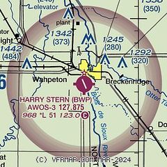
|
| Airport distance calculator |
|---|
|
|
| Sunrise and sunset |
|---|
|
Times for 07-Jan-2026
| | Local
(UTC-6) | | Zulu
(UTC) |
|---|
| Morning civil twilight | | 07:35 | | 13:35 |
| Sunrise | | 08:10 | | 14:10 |
| Sunset | | 16:56 | | 22:56 |
| Evening civil twilight | | 17:30 | | 23:30 |
|
| Current date and time |
|---|
| Zulu (UTC) | 07-Jan-2026 20:46:54 |
|---|
| Local (UTC-6) | 07-Jan-2026 14:46:54 |
|---|
|
| METAR |
|---|
| KBWP | 072035Z AUTO 15007KT 10SM CLR 01/01 A2956 RMK AO2
|
KFFM
19nm E | 072035Z AUTO 15008KT 10SM CLR 03/01 A2957 RMK AO2
|
|
| TAF |
|---|
KFAR
42nm N | 071728Z 0718/0818 17009KT P6SM BKN250 FM081500 31007KT P6SM SCT250
|
|
| NOTAMs |
|---|
NOTAMs are issued by the DoD/FAA and will open in a separate window not controlled by AirNav.
|
|

