FAA INFORMATION EFFECTIVE 14 MAY 2026
Location
| FAA Identifier: | GBD |
| Lat/Long: | 38-20-39.3050N 098-51-33.1090W
38-20.655083N 098-51.551817W
38.3442514,-98.8591969
(estimated) |
| Elevation: | 1886.7 ft. / 575.1 m (surveyed) |
| Variation: | 08E (1990) |
| From city: | 4 miles W of GREAT BEND, KS |
| Time zone: | UTC -5 (UTC -6 during Standard Time) |
| Zip code: | 67530 |
Airport Operations
| Airport use: | Open to the public |
| Activation date: | 06/1943 |
| Control tower: | no |
| ARTCC: | KANSAS CITY CENTER |
| FSS: | WICHITA FLIGHT SERVICE STATION |
| NOTAMs facility: | GBD (NOTAM-D service available) |
| Attendance: | 0630-1800
AFTER 1800 BY REQUEST. |
| Wind indicator: | lighted |
| Segmented circle: | yes |
| Lights: | ACTVT MALSR RWY 35; REIL RWY 17; PAPI RWY 11, 17 & 29; VASI RWY 35; MIRL 11/29 & 17/35 - CTAF. |
| Beacon: | white-green (lighted land airport)
Operates sunset to sunrise. |
Airport Communications
| CTAF/UNICOM: | 122.8 |
| WX AWOS-3PT: | 119.275 (620-792-5019) |
| WX AWOS-3PT at LQR (13 nm SW): | 119.875 (620-285-8552) |
- COMMUNICATIONS PRVDD BY WICHITA RADIO ON FREQ 122.5 (GREAT BEND RCO).
- APCH/DEP CTL SVC PRVDD BY KANSAS CITY ARTCC (ZKC) ON FREQS 118.8/322.425 (HUTCHINSON RCAG).
Nearby radio navigation aids
| VOR radial/distance | | VOR name | | Freq | | Var |
|---|
| HYSr137/36.0 | | HAYS VORTAC | | 110.40 | | 10E |
| NDB name | | Hdg/Dist | | Freq | | Var | | ID |
|---|
| BABSY | | 350/5.6 | | 419 | | 08E | | GB | --. -... |
Airport Services
| Fuel available: | 100LL JET-A
100LL:24 HR CREDIT CARD SVC AVBL. |
| Parking: | hangars and tiedowns |
| Airframe service: | MAJOR |
| Powerplant service: | MAJOR |
| Bulk oxygen: | LOW |
Runway Information
Runway 17/35
| Dimensions: | 7852 x 100 ft. / 2393 x 30 m |
| Surface: | concrete/aggregate friction seal coat, in fair condition |
| Weight bearing capacity: | | PCN 19 /R/C/X/U | | Single wheel: | 28.0 | | Double wheel: | 35.0 | | Double tandem: | 86.0 |
|
| Runway edge lights: | medium intensity |
| RUNWAY 17 | | RUNWAY 35 |
| Latitude: | 38-21.471480N | | 38-20.177958N |
| Longitude: | 098-51.441657W | | 098-51.429895W |
| Elevation: | 1881.3 ft. | | 1882.5 ft. |
| Traffic pattern: | left | | left |
| Runway heading: | 172 magnetic, 180 true | | 352 magnetic, 360 true |
| Declared distances: | TORA:7852 TODA:7852 ASDA:7852 LDA:7852 | | TORA:7852 TODA:7852 ASDA:7852 LDA:7852 |
| Markings: | nonprecision, in good condition | | precision, in good condition |
| Visual slope indicator: | 4-light PAPI on left (3.50 degrees glide path) | | 4-box VASI on left (3.00 degrees glide path) |
| Approach lights: | | | MALSR: 1,400 foot medium intensity approach lighting system with runway alignment indicator lights |
| Runway end identifier lights: | yes | | |
| Touchdown point: | yes, no lights | | yes, no lights |
| Instrument approach: | | | ILS/DME |
Runway 11/29
| Dimensions: | 4706 x 75 ft. / 1434 x 23 m |
| Surface: | asphalt, in fair condition |
| Weight bearing capacity: | | PCN 9 /R/C/X/U | | Single wheel: | 28.0 | | Double wheel: | 35.0 | | Double tandem: | 86.0 |
|
| Runway edge lights: | medium intensity |
| RUNWAY 11 | | RUNWAY 29 |
| Latitude: | 38-20.563360N | | 38-20.180650N |
| Longitude: | 098-52.173440W | | 098-51.317445W |
| Elevation: | 1886.7 ft. | | 1882.7 ft. |
| Traffic pattern: | left | | left |
| Runway heading: | 112 magnetic, 120 true | | 292 magnetic, 300 true |
| Declared distances: | TORA:4706 TODA:4706 ASDA:4706 LDA:4706 | | TORA:4706 TODA:4706 ASDA:4706 LDA:4706 |
| Markings: | nonprecision, in good condition | | nonprecision, in good condition |
| Visual slope indicator: | 4-light PAPI on left (3.00 degrees glide path) | | 4-light PAPI on left (3.00 degrees glide path) |
| Touchdown point: | yes, no lights | | yes, no lights |
Airport Ownership and Management from official FAA records
| Ownership: | Publicly-owned |
| Owner: | CITY OF GREAT BEND
1209 WILLIAMS ST, CITY HALL, BOX 1168
GREAT BEND, KS 67530
Phone 620-793-4111 |
| Manager: | MARTIN MILLER
9047 6TH ST,, BOX 1168
GREAT BEND, KS 67530
Phone 620-793-4168
AMGR CELL 620-792-9446. |
Additional Remarks
| - | CALM WIND RWY 17. |
| - | 100LL AND JET A SELF-SERVE FUEL AVBL N END OF TRML APRON. CALL FBO 620-796-2130 FOR FUEL PRICES. |
| - | FOR CD IF UNA TO CTC ON FSS FREQ, CTC KANSAS CITY ARTCC AT 913-254-8508. |
Instrument Procedures
NOTE: All procedures below are presented as PDF files. If you need a reader for these files, you should download the free Adobe Reader.NOT FOR NAVIGATION. Please procure official charts for flight.
FAA instrument procedures published for use from 14 May 2026 at 0901Z to 11 June 2026 at 0900z.
IAPs - Instrument Approach Procedures |
|---|
| ILS OR LOC RWY 35 | |
download (210KB) |
| RNAV (GPS) RWY 17 | |
download (210KB) |
| RNAV (GPS) RWY 35 | |
download (281KB) |
| NOTE: Special Alternate Minimums apply | |
download (139KB) |
| NOTE: Special Take-Off Minimums/Departure Procedures apply | |
download (147KB) |
Other nearby airports with instrument procedures:
KLQR - Larned-Pawnee County Airport (13 nm SW)
KLYO - Lyons-Rice County Municipal Airport (30 nm E)
KRSL - Russell Municipal Airport (32 nm N)
KHYS - Hays Regional Airport (36 nm NW)
9K7 - Ellsworth Municipal Airport (38 nm NE)
|
|

Road maps at:
MapQuest
Bing
Google
| Aerial photo |
|---|
WARNING: Photo may not be current or correct
 Photo taken 14-May-2008
Do you have a better or more recent aerial photo of Great Bend Municipal Airport that you would like to share? If so, please send us your photo.
|
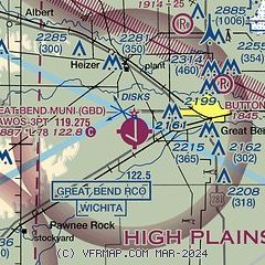
| Sectional chart |
|---|
|
 Download PDF
of official airport diagram from the FAA
| Airport distance calculator |
|---|
|
|
| Sunrise and sunset |
|---|
|
Times for 14-May-2026
| | Local
(UTC-5) | | Zulu
(UTC) |
|---|
| Morning civil twilight | | 05:56 | | 10:56 |
| Sunrise | | 06:26 | | 11:26 |
| Sunset | | 20:38 | | 01:38 |
| Evening civil twilight | | 21:07 | | 02:07 |
|
| Current date and time |
|---|
| Zulu (UTC) | 14-May-2026 23:06:06 |
|---|
| Local (UTC-5) | 14-May-2026 18:06:06 |
|---|
|
| METAR |
|---|
| KGBD | 142256Z AUTO 19018G26KT 10SM CLR 33/09 A2963 RMK AO2 PK WND 18029/2245 SLPNO T03330089 $
|
KLQR
13nm SW | 142235Z AUTO 19019G22KT 10SM CLR 35/08 A2963 RMK AO2
|
|
| TAF |
|---|
| KGBD | 141720Z 1418/1518 20018G26KT P6SM SCT250 FM142200 24015G22KT P6SM FEW100 SCT250 PROB30 1422/1502 VRB20G40KT 5SM -TSRA BKN100CB FM150200 VRB06KT P6SM SCT100
|
|
| NOTAMs |
|---|
NOTAMs are issued by the DoD/FAA and will open in a separate window not controlled by AirNav.
|
|


