FAA INFORMATION EFFECTIVE 19 FEBRUARY 2026
Location
| FAA Identifier: | GED |
| Lat/Long: | 38-41-15.4780N 075-21-33.4960W
38-41.257967N 075-21.558267W
38.6876328,-75.3593044
(estimated) |
| Elevation: | 53.3 ft. / 16.2 m (surveyed) |
| Variation: | 12W (2000) |
| From city: | 2 miles SE of GEORGETOWN, DE |
| Time zone: | UTC -5 (UTC -4 during Daylight Saving Time) |
| Zip code: | 19947 |
Airport Operations
| Airport use: | Open to the public |
| Control tower: | no |
| ARTCC: | WASHINGTON CENTER |
| FSS: | MILLVILLE FLIGHT SERVICE STATION |
| NOTAMs facility: | GED (NOTAM-D service available) |
| Attendance: | 0800-1800
ARPT UNATNDD THANKSGIVING DAY AND CHRISTMAS DAY. |
| Wind indicator: | lighted |
| Segmented circle: | yes |
| Lights: | ACTVT MALS RWY 4; REIL RWY 04, 22, 10, 28; MIRL RWY 04/22 & 10/28 - CTAF. |
| Beacon: | white-green (lighted land airport)
Operates sunset to sunrise. |
| International operations: | customs landing rights airport |
Airport Communications
| CTAF/UNICOM: | 123.0 |
| WX ASOS: | 118.375 (302-855-1052) |
| DOVER APPROACH: | 132.425 |
| DOVER DEPARTURE: | 132.425 |
Nearby radio navigation aids
| VOR radial/distance | | VOR name | | Freq | | Var |
|---|
| ATRr232/10.1 | | WATERLOO VOR/DME | | 112.60 | | 09W |
| ENOr176/33.4 | | SMYRNA VORTAC | | 111.40 | | 09W |
| SIEr236/35.8 | | SEA ISLE VORTAC | | 114.80 | | 09W |
Airport Services
| Fuel available: | 100LL JET-A |
| Parking: | tiedowns |
| Airframe service: | MAJOR |
| Powerplant service: | MAJOR |
| Bottled oxygen: | NONE |
Runway Information
Runway 4/22
| Dimensions: | 5500 x 150 ft. / 1676 x 46 m |
| Surface: | asphalt/grooved, in good condition |
| Weight bearing capacity: | | PCN 43 /F/A/X/T | | Single wheel: | 50.0 | | Double wheel: | 175.0 |
|
| Runway edge lights: | medium intensity |
| Operational restrictions: | RWY 04/22 SUBJ TO FQT RWY ACFT BACKTAXI OPS. |
| RUNWAY 4 | | RUNWAY 22 |
| Latitude: | 38-40.974325N | | 38-41.734883N |
| Longitude: | 075-21.948960W | | 075-21.320803W |
| Elevation: | 48.9 ft. | | 48.5 ft. |
| Traffic pattern: | left | | left |
| Runway heading: | 045 magnetic, 033 true | | 225 magnetic, 213 true |
| Displaced threshold: | 370 ft. | | 169 ft. |
| Markings: | nonprecision, in good condition | | nonprecision, in good condition |
| Visual slope indicator: | 4-light PAPI on left (3.00 degrees glide path) | | 4-light PAPI on left (3.00 degrees glide path) |
| Approach lights: | MALS: 1,400 foot medium intensity approach lighting system | | |
| Runway end identifier lights: | yes | | yes |
| Touchdown point: | yes, no lights | | yes, no lights |
| Obstructions: | 49 ft. trees, 1258 ft. from runway, 140 ft. left of centerline, 21:1 slope to clear | | none |
Runway 10/28
| Dimensions: | 3109 x 75 ft. / 948 x 23 m |
| Surface: | asphalt, in good condition |
| Weight bearing capacity: | | PCN 36 /F/A/X/T | | Single wheel: | 50.0 | | Double wheel: | 91.0 |
|
| Runway edge lights: | medium intensity |
| RUNWAY 10 | | RUNWAY 28 |
| Latitude: | 38-41.087030N | | 38-41.086925N |
| Longitude: | 075-21.749400W | | 075-21.096002W |
| Elevation: | 49.0 ft. | | 53.3 ft. |
| Traffic pattern: | left | | left |
| Runway heading: | 102 magnetic, 090 true | | 282 magnetic, 270 true |
| Markings: | basic, in good condition | | basic, in good condition |
| Visual slope indicator: | 2-light PAPI on left (3.50 degrees glide path) | | 2-light PAPI on left (3.00 degrees glide path) |
| Runway end identifier lights: | yes | | yes |
| Touchdown point: | yes, no lights | | yes, no lights |
Airport Ownership and Management from official FAA records
| Ownership: | Publicly-owned |
| Owner: | SUSSEX COUNTY COUNCIL
PO BOX 589
GEORGETOWN, DE 19947
Phone 302-855-7770 |
| Manager: | ROBERT L. BRYANT
21553 RUDDER LANE
GEORGETOWN, DE 19947
Phone 302-855-7774
ROBERT.BRYANT@SUSSEXCOUNTYDE.GOV. |
Additional Remarks
| - | PAEW WITHIN SAFETY AREA OF RWYS & TWYS. |
| - | BIRDS, DEER, AND OTHER WILDLIFE INVOF RWYS. |
| - | FOR CD IF UNA VIA GCO FREQ, CTC DOVER APCH AT 302-677-3940. IF DOVER APCH UNA, CTC WASHINGTON ARTCC AT 703-771-3587. |
| - | GCO AVBL ON FREQ 125.55. |
| - | FBO HRS 0800-1800 LST. FOR SVC/FUEL AFT HRS CALL 302-855-2355. |
Instrument Procedures
NOTE: All procedures below are presented as PDF files. If you need a reader for these files, you should download the free Adobe Reader.NOT FOR NAVIGATION. Please procure official charts for flight.
FAA instrument procedures published for use from 19 February 2026 at 0901Z to 19 March 2026 at 0900Z.
IAPs - Instrument Approach Procedures |
|---|
| RNAV (GPS) RWY 04 | |
download (223KB) |
| RNAV (GPS) RWY 22 | |
download (214KB) |
| VOR RWY 04 | |
download (233KB) |
| VOR RWY 22 | |
download (220KB) |
| NOTE: Special Alternate Minimums apply | |
download (41KB) |
Departure Procedures |
|---|
| GEORGETOWN ONE | |
download (147KB) |
| NOTE: Special Take-Off Minimums/Departure Procedures apply | |
download (217KB) |
Other nearby airports with instrument procedures:
N06 - Laurel Airport (14 nm SW)
KSBY - Salisbury-Ocean City Wicomico Regional Airport (22 nm S)
KOXB - Ocean City Municipal Airport (25 nm SE)
KDOV - Dover Air Force Base (27 nm N)
KWWD - Cape May County Airport (29 nm NE)
|
|

Road maps at:
MapQuest
Bing
Google
| Aerial photo |
|---|
WARNING: Photo may not be current or correct
 Photo by Robert Thomas
Photo taken 25-Oct-2009
from a 1947 Cessna 140.
Photo by Robert Thomas
Photo taken 25-Oct-2009
from a 1947 Cessna 140.
Do you have a better or more recent aerial photo of Delaware Coastal Airport that you would like to share? If so, please send us your photo.
|
| Sectional chart |
|---|
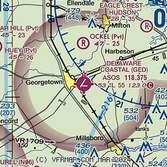
|
| Airport distance calculator |
|---|
|
|
| Sunrise and sunset |
|---|
|
Times for 03-Mar-2026
| | Local
(UTC-5) | | Zulu
(UTC) |
|---|
| Morning civil twilight | | 06:05 | | 11:05 |
| Sunrise | | 06:32 | | 11:32 |
| Sunset | | 17:55 | | 22:55 |
| Evening civil twilight | | 18:22 | | 23:22 |
|
| Current date and time |
|---|
| Zulu (UTC) | 04-Mar-2026 04:12:31 |
|---|
| Local (UTC-5) | 03-Mar-2026 23:12:31 |
|---|
|
| METAR |
|---|
| KGED | 040354Z AUTO 22010KT 9SM SCT006 BKN075 OVC110 07/06 A3026 RMK AO2 SLP246 T00720061
|
|
| TAF |
|---|
KSBY
22nm S | 040218Z 0402/0424 21008KT P6SM -RA SCT007 BKN080 TEMPO 0402/0404 4SM -RA BR OVC007 FM040400 20007KT P6SM VCSH OVC007 FM040800 22007KT P6SM OVC015 FM041200 26004KT P6SM BKN020
|
KDOV
26nm N | 040000Z 0400/0506 21009KT 6000 BR BKN004 BKN100 651008 QNH3025INS BECMG 0402/0404 21009KT 6000 -RA BR BKN020 BKN080 650808 510009 QNH3020INS TEMPO 0404/0408 BKN010 BECMG 0408/0409 24006KT 8000 BR OVC020 620809 520009 QNH3020INS BECMG 0416/0417 34006KT 8000 -RA BR OVC010 620809 QNH3021INS TX12/0419Z TN06/0400Z
|
|
| NOTAMs |
|---|
NOTAMs are issued by the DoD/FAA and will open in a separate window not controlled by AirNav.
|
|


