FAA INFORMATION EFFECTIVE 11 JUNE 2026
Location
| FAA Identifier: | HJH |
| Lat/Long: | 40-09-07.0000N 097-35-04.3000W
40-09.116667N 097-35.071667W
40.1519444,-97.5845278
(estimated) |
| Elevation: | 1468.2 ft. / 447.5 m (surveyed) |
| Variation: | 04E (2015) |
| From city: | 1 mile S of HEBRON, NE |
| Time zone: | UTC -5 (UTC -6 during Standard Time) |
| Zip code: | 68370 |
Airport Operations
| Airport use: | Open to the public |
| Activation date: | 03/1941 |
| Control tower: | no |
| ARTCC: | MINNEAPOLIS CENTER |
| FSS: | COLUMBUS FLIGHT SERVICE STATION |
| NOTAMs facility: | HJH (NOTAM-D service available) |
| Attendance: | UNATNDD |
| Wind indicator: | lighted |
| Segmented circle: | yes |
| Lights: | ACTVT MIRL RY 12/30; PAPI & REIL RYS 12 & 30 - CTAF. |
| Beacon: | white-green (lighted land airport)
Operates sunset to sunrise. |
Airport Communications
| CTAF: | 122.9 |
| WX AWOS-3: | 118.525 (402-768-2501) |
- APCH/DEP SVC PRVDD BY MINNEAPOLIS ARTCC ON FREQS 126.4/317.7 (MARYSVILLE RCAG).
Nearby radio navigation aids
| VOR radial/distance | | VOR name | | Freq | | Var |
|---|
| BIEr250/(39.1) | | BEATRICE VOR | | 110.60 | | 07E |
| NDB name | | Hdg/Dist | | Freq | | Var | | ID |
|---|
| FAIRBURY | | 260/19.3 | | 293 | | 06E | | FBY | ..-. -... -.-- |
| BEKLOF | | 179/26.3 | | 392 | | 03E | | FMZ | ..-. -- --.. |
Airport Services
| Fuel available: | 100LL JET-A
100LL:FUEL AVBL H24 VIA CREDIT CARD. IF UNAVBL CALL (402) 768-6597. |
| Parking: | hangars and tiedowns |
| Airframe service: | AIRFRAME RPRS BY APNTMT ONLY. |
| Powerplant service: | PWR PLANT RPRS BY APNTMT ONLY. |
| Bottled oxygen: | NONE |
| Bulk oxygen: | NONE |
Runway Information
Runway 12/30
| Dimensions: | 3600 x 60 ft. / 1097 x 18 m |
| Surface: | concrete, in good condition |
| Weight bearing capacity: | |
| Runway edge lights: | medium intensity |
| RUNWAY 12 | | RUNWAY 30 |
| Latitude: | 40-09.319690N | | 40-08.951367N |
| Longitude: | 097-35.521492W | | 097-34.915950W |
| Elevation: | 1462.2 ft. | | 1465.6 ft. |
| Traffic pattern: | left | | left |
| Runway heading: | 124 magnetic, 128 true | | 304 magnetic, 308 true |
| Markings: | nonprecision, in good condition | | nonprecision, in good condition |
| Visual slope indicator: | 2-light PAPI on left (3.90 degrees glide path) | | 2-light PAPI on left (3.00 degrees glide path) |
| Runway end identifier lights: | yes | | yes |
| Touchdown point: | yes, no lights | | yes, no lights |
| Obstructions: | 61 ft. tree, 1428 ft. from runway, 315 ft. right of centerline, 20:1 slope to clear | | 27 ft. road, 743 ft. from runway, 20:1 slope to clear |
Runway 3/21
| Dimensions: | 2513 x 150 ft. / 766 x 46 m |
| Surface: | turf, in fair condition |
| Runway edge markings: | MKD WITH REFLECTORS & YELLOW CONES. |
| RUNWAY 3 | | RUNWAY 21 |
| Latitude: | 40-08.937190N | | 40-09.245867N |
| Longitude: | 097-35.039252W | | 097-34.680073W |
| Elevation: | 1468.2 ft. | | 1451.8 ft. |
| Traffic pattern: | left | | left |
| Runway heading: | 038 magnetic, 042 true | | 218 magnetic, 222 true |
| Touchdown point: | yes, no lights | | yes, no lights |
| Obstructions: | 54 ft. trees, 1085 ft. from runway, 222 ft. right of centerline, 20:1 slope to clear
RWY 21 8 FT TALL CORN IN SUMMER CAN CREATE 22:1. | | none
RWY 21 8 FT TALL CORN IN SUMMER CAN CREATE 22:1. |
Airport Ownership and Management from official FAA records
| Ownership: | Publicly-owned |
| Owner: | HEBRON ARPT AUTHORITY
P.O. BOX 256
HEBRON, NE 68370-0256
Phone (402) 768-6597 |
| Manager: | WILLIAM LINTON
1115 OLIVE AVE
HEBRON, NE 68370-1317
Phone (402) 768-6597 |
Additional Remarks
| - | APCHS PROTECTED BY STRUCTURE CTL ORDINANCE. |
| - | FOR CD CTC MINNEAPOLIS ARTCC AT 651-463-5588. |
Instrument Procedures
NOTE: All procedures below are presented as PDF files. If you need a reader for these files, you should download the free Adobe Reader.NOT FOR NAVIGATION. Please procure official charts for flight.
FAA instrument procedures published for use from 11 June 2026 at 0901Z to 09 July 2026 at 0900z.
IAPs - Instrument Approach Procedures |
|---|
| RNAV (GPS) RWY 12 | |
download (194KB) |
| GPS RWY 30 | |
download (176KB) |
| NOTE: Special Alternate Minimums apply | |
download (140KB) |
| NOTE: Special Take-Off Minimums/Departure Procedures apply | |
download (219KB) |
Other nearby airports with instrument procedures:
KFBY - Fairbury Municipal Airport (19 nm E)
KRPB - Belleville Municipal Airport (20 nm S)
12K - Superior Municipal Airport (23 nm W)
KFMZ - Fairmont State Airport (26 nm N)
K38 - Washington County Veteran's Memorial Airport (35 nm SE)
|
|

Road maps at:
MapQuest
Bing
Google
| Aerial photo |
|---|
WARNING: Photo may not be current or correct
 Photo taken 21-Aug-2017
looking east.
Photo taken 21-Aug-2017
looking east.
Do you have a better or more recent aerial photo of Hebron Municipal Airport that you would like to share? If so, please send us your photo.
|
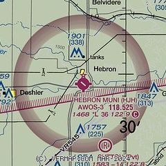
| Sectional chart |
|---|
|
| Airport distance calculator |
|---|
|
|
| Sunrise and sunset |
|---|
|
Times for 16-Jun-2026
| | Local
(UTC-5) | | Zulu
(UTC) |
|---|
| Morning civil twilight | | 05:28 | | 10:28 |
| Sunrise | | 06:01 | | 11:01 |
| Sunset | | 21:01 | | 02:01 |
| Evening civil twilight | | 21:34 | | 02:34 |
|
| Current date and time |
|---|
| Zulu (UTC) | 16-Jun-2026 18:13:36 |
|---|
| Local (UTC-5) | 16-Jun-2026 13:13:36 |
|---|
|
| METAR |
|---|
| KHJH | 161735Z AUTO 06004KT 10SM CLR 25/06 A2985 RMK AO2 T02480056
|
|
| NOTAMs |
|---|
NOTAMs are issued by the DoD/FAA and will open in a separate window not controlled by AirNav.
|
|

