FAA INFORMATION EFFECTIVE 16 APRIL 2026
Location
| FAA Identifier: | JTC |
| Lat/Long: | 34-07-45.9000N 109-18-39.1000W
34-07.765000N 109-18.651667W
34.1294167,-109.3108611
(estimated) |
| Elevation: | 7055.2 ft. / 2150.4 m (surveyed) |
| Variation: | 12E (1995) |
| From city: | 1 mile WSW of SPRINGERVILLE, AZ |
| Time zone: | UTC -7 (year round; does not observe DST) |
| Zip code: | 85938 |
Airport Operations
| Airport use: | Open to the public |
| Control tower: | no |
| ARTCC: | ALBUQUERQUE CENTER |
| FSS: | PRESCOTT FLIGHT SERVICE STATION |
| NOTAMs facility: | PRC (NOTAM-D service available) |
| Attendance: | 0800-1600 |
| Wind indicator: | lighted |
| Segmented circle: | yes |
| Lights: | ACTVT PAPI RWY 03, 11 & 21; MIRL RWY 03/21 & 11/29 - CTAF: 5 CLICKS ON; 7 CLICKS OFF. |
| Beacon: | white-green (lighted land airport)
Operates sunset to sunrise. |
Airport Communications
| CTAF/UNICOM: | 122.8 |
| WX AWOS-3PT: | 119.65 (928-333-5716) |
- APCH/DEP SVC PRVDD BY ALBUQUERQUE ARTCC (ABQ) ON FREQS 132.9/239.05 (GLOBE NR 1 RCAG).
Nearby radio navigation aids
| VOR radial/distance | | VOR name | | Freq | | Var |
|---|
| SJNr193/19.5 | | ST JOHNS VORTAC | | 112.30 | | 12E |
Airport Services
| Fuel available: | 100LL JET-A+
100LL:AFT HR - 928-245-0151. |
| Parking: | hangars and tiedowns |
Runway Information
Runway 3/21
| Dimensions: | 8422 x 75 ft. / 2567 x 23 m |
| Surface: | asphalt, in good condition |
| Weight bearing capacity: | |
| Runway edge lights: | medium intensity |
| RUNWAY 3 | | RUNWAY 21 |
| Latitude: | 34-07.318667N | | 34-08.320377N |
| Longitude: | 109-19.245782W | | 109-18.090322W |
| Elevation: | 7055.1 ft. | | 7011.7 ft. |
| Traffic pattern: | left | | right |
| Runway heading: | 032 magnetic, 044 true | | 212 magnetic, 224 true |
| Markings: | nonprecision, in good condition | | nonprecision, in good condition |
| Visual slope indicator: | 2-light PAPI on left (4.00 degrees glide path)
PAPI DOES NOT PROVIDE OBSTN CLEARANCE 2 NM BYD THR. | | 2-light PAPI on left (3.00 degrees glide path) |
| Touchdown point: | yes, no lights | | yes, no lights |
Runway 11/29
| Dimensions: | 4603 x 60 ft. / 1403 x 18 m |
| Surface: | asphalt, in good condition |
| Weight bearing capacity: | |
| Runway edge lights: | medium intensity |
| RUNWAY 11 | | RUNWAY 29 |
| Latitude: | 34-07.898347N | | 34-07.436390N |
| Longitude: | 109-18.984658W | | 109-18.260968W |
| Elevation: | 7032.8 ft. | | 7042.0 ft. |
| Traffic pattern: | left | | left |
| Runway heading: | 116 magnetic, 128 true | | 296 magnetic, 308 true |
| Markings: | basic, in poor condition | | basic, in poor condition |
| Visual slope indicator: | 2-light PAPI on left (3.00 degrees glide path) | | |
| Touchdown point: | yes, no lights | | yes, no lights |
Airport Ownership and Management from official FAA records
| Ownership: | Publicly-owned |
| Owner: | TOWN OF SPRINGERVILLE
418 EAST MAIN STREET
SPRINGERVILLE, AZ 85938
Phone 928-333-2656 |
| Manager: | TOWN OF SPRINGERVILLE
905 WEST AIRPORT RD
SPRINGERVILLE, AZ 85938
Phone 928-333-5746 |
Additional Remarks
| - | MIL TFC INVOF ARPT. |
| - | WILDLIFE ON & INVOF ARPT. |
| - | DENSITY INDCR AT FUEL PUMPS. |
| - | FOR CD CTC ALBUQUERQUE ARTCC AT 505-856-4861. |
Instrument Procedures
NOTE: All procedures below are presented as PDF files. If you need a reader for these files, you should download the free Adobe Reader.NOT FOR NAVIGATION. Please procure official charts for flight.
FAA instrument procedures published for use from 16 April 2026 at 0901Z to 14 May 2026 at 0900Z.
IAPs - Instrument Approach Procedures |
|---|
| RNAV (GPS) RWY 21 | |
download (200KB) |
| NOTE: Special Take-Off Minimums/Departure Procedures apply | |
download (355KB) |
Other nearby airports with instrument procedures:
KSJN - St Johns Industrial Air Park (24 nm N)
KSOW - Show Low Regional Airport (35 nm W)
KTYL - Taylor Airport (44 nm NW)
KCFT - Greenlee County Airport (71 nm S)
KSAD - Safford Regional Airport/1LT Duane Spalsbury Field (78 nm S)
|
|

Road maps at:
MapQuest
Bing
Google
| Aerial photo |
|---|
WARNING: Photo may not be current or correct
 Photo taken 24-Sep-2005
Do you have a better or more recent aerial photo of Springerville Municipal Airport that you would like to share? If so, please send us your photo.
|
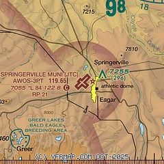
| Sectional chart |
|---|
|
| Airport distance calculator |
|---|
|
|
| Sunrise and sunset |
|---|
|
Times for 23-Apr-2026
| | Local
(UTC-7) | | Zulu
(UTC) |
|---|
| Morning civil twilight | | 05:11 | | 12:11 |
| Sunrise | | 05:37 | | 12:37 |
| Sunset | | 18:54 | | 01:54 |
| Evening civil twilight | | 19:20 | | 02:20 |
|
| Current date and time |
|---|
| Zulu (UTC) | 23-Apr-2026 20:39:16 |
|---|
| Local (UTC-7) | 23-Apr-2026 13:39:16 |
|---|
|
| METAR |
|---|
| KJTC | 232015Z AUTO 26015G27KT 220V310 10SM CLR 19/M14 A3002 RMK AO2
|
|
| NOTAMs |
|---|
NOTAMs are issued by the DoD/FAA and will open in a separate window not controlled by AirNav.
|
|


