FAA INFORMATION EFFECTIVE 09 JULY 2026
Location
| FAA Identifier: | LWC |
| Lat/Long: | 39-00-40.0000N 095-12-59.3000W
39-00.666667N 095-12.988333W
39.0111111,-95.2164722
(estimated) |
| Elevation: | 833.2 ft. / 254.0 m (surveyed) |
| Variation: | 04E (2005) |
| From city: | 3 miles N of LAWRENCE, KS |
| Time zone: | UTC -5 (UTC -6 during Standard Time) |
| Zip code: | 66044 |
Airport Operations
| Airport use: | Open to the public |
| Activation date: | 04/1940 |
| Control tower: | no |
| ARTCC: | KANSAS CITY CENTER |
| FSS: | WICHITA FLIGHT SERVICE STATION |
| NOTAMs facility: | LWC (NOTAM-D service available) |
| Attendance: | 0800-2000 |
| Wind indicator: | lighted |
| Segmented circle: | yes |
| Lights: | ACTVT MALSR RWY 33; REIL RWY 01, 15, & 19; PAPI RWY 01, 19, 15 & 33; MIRL RWY 01/19 & 15/33 - CTAF. |
| Beacon: | white-green (lighted land airport)
Operates sunset to sunrise. |
Airport Communications
| CTAF/UNICOM: | 123.0 |
| WX ASOS: | 121.225 (785-749-1309) |
| WX ASOS at IXD (19 nm SE): | 135.325 (913-780-6987) |
| WX ASOS at TOP (19 nm W): | 121.275 (785-274-8258) |
- RADAR COVERAGE DOWN TO 600'.
- APCH/DEP CTL SVC PRVDD BY KANSAS CITY ARTCC (ZKC) ON FREQS 123.8/343.7 (TOPEKA RCAG).
- A/G COMMUNICATIONS FOR DEPARTURE CTL AVAILABLE ABOVE 500'.
- CD PRVDD BY KANSAS CITY ARTCC ON FREQ 121.825.
Nearby radio navigation aids
| VOR radial/distance | | VOR name | | Freq | | Var |
|---|
| TOPr111/17.2 | | TOPEKA VORTAC | | 117.80 | | 05E |
| MCIr229/27.7 | | KANSAS CITY VORTAC | | 113.25 | | 05E |
| NDB name | | Hdg/Dist | | Freq | | Var | | ID |
|---|
| NEWBN | | 329/6.5 | | 338 | | 04E | | JZ | .--- --.. |
Airport Services
| Fuel available: | 100LL JET-A
100LL:AFT HRS FUEL CTC - 785-865-6500. |
| Parking: | hangars and tiedowns |
| Airframe service: | MAJOR |
| Powerplant service: | MAJOR |
| Bottled oxygen: | HIGH |
| Bulk oxygen: | HIGH |
Runway Information
Runway 15/33
| Dimensions: | 5701 x 100 ft. / 1738 x 30 m |
| Surface: | asphalt, in excellent condition |
| Weight bearing capacity: | | PCN 16 /F/C/Y/U | | Single wheel: | 40.0 | | Double wheel: | 60.0 |
|
| Runway edge lights: | medium intensity |
| RUNWAY 15 | | RUNWAY 33 |
| Latitude: | 39-01.119550N | | 39-00.279397N |
| Longitude: | 095-13.205390W | | 095-12.667735W |
| Elevation: | 831.5 ft. | | 827.1 ft. |
| Traffic pattern: | left | | left |
| Runway heading: | 149 magnetic, 153 true | | 329 magnetic, 333 true |
| Markings: | nonprecision, in good condition | | precision, in good condition |
| Visual slope indicator: | 4-light PAPI on left (3.00 degrees glide path) | | 4-light PAPI on right (3.00 degrees glide path) |
| Approach lights: | | | MALSR: 1,400 foot medium intensity approach lighting system with runway alignment indicator lights |
| Runway end identifier lights: | yes | | |
| Touchdown point: | yes, no lights | | yes, no lights |
| Instrument approach: | | | ILS |
| Obstructions: | none | | 49 ft. trees, 2462 ft. from runway, 531 ft. left of centerline, 46:1 slope to clear |
Runway 1/19
| Dimensions: | 3901 x 75 ft. / 1189 x 23 m |
| Surface: | concrete, in good condition |
| Weight bearing capacity: | | PCN 4 /R/D/Y/U | | Single wheel: | 12.5 | | Double wheel: | 15.6 |
|
| Runway edge lights: | medium intensity |
| RUNWAY 1 | | RUNWAY 19 |
| Latitude: | 39-00.316850N | | 39-00.923782N |
| Longitude: | 095-13.198060W | | 095-12.927475W |
| Elevation: | 832.5 ft. | | 831.1 ft. |
| Traffic pattern: | left | | left |
| Runway heading: | 015 magnetic, 019 true | | 195 magnetic, 199 true |
| Markings: | nonprecision, in fair condition | | nonprecision, in fair condition |
| Visual slope indicator: | 2-light PAPI on left (3.50 degrees glide path) | | 2-light PAPI on left (3.50 degrees glide path) |
| Runway end identifier lights: | yes | | yes |
| Touchdown point: | yes, no lights | | yes, no lights |
Airport Ownership and Management from official FAA records
| Ownership: | Publicly-owned |
| Owner: | CITY OF LAWRENCE
6 E 6TH ST., PO BOX 708
LAWRENCE, KS 66044
Phone 785-832-3467 |
| Manager: | SCOTT WAGNER
LAWRENCE KS CITY HALL, 6 EAST 6TH STREET
LAWRENCE, KS 66044
Phone 785-832-3467
AFT HRS APRT MGR CTC - 785-813-5765 |
Instrument Procedures
NOTE: All procedures below are presented as PDF files. If you need a reader for these files, you should download the free Adobe Reader.NOT FOR NAVIGATION. Please procure official charts for flight.
FAA instrument procedures published for use from 09 July 2026 at 0901Z to 06 August 2026 at 0900Z.
IAPs - Instrument Approach Procedures |
|---|
| ILS OR LOC RWY 33 | |
download (233KB) |
| RNAV (GPS) RWY 15 | |
download (215KB) |
| RNAV (GPS) RWY 33 | |
download (256KB) |
| VOR/DME-A | |
download (176KB) |
| NOTE: Special Alternate Minimums apply | |
download (146KB) |
| NOTE: Special Take-Off Minimums/Departure Procedures apply | |
download (351KB) |
Other nearby airports with instrument procedures:
KIXD - New Century AirCenter Airport (19 nm SE)
KTOP - Philip Billard Municipal Airport (19 nm W)
KFOE - Topeka Regional Airport (21 nm W)
KOJC - Johnson County Executive Airport (24 nm SE)
KFLV - Sherman Army Airfield (26 nm NE)
|
|

Road maps at:
MapQuest
Bing
Google
| Aerial photo |
|---|
WARNING: Photo may not be current or correct
 Photo courtesy of AirNav, LLC
Photo taken 15-Sep-2013
looking east.
Photo courtesy of AirNav, LLC
Photo taken 15-Sep-2013
looking east.
Do you have a better or more recent aerial photo of Lawrence Regional Airport that you would like to share? If so, please send us your photo.
|
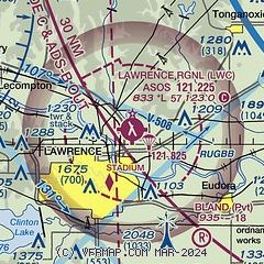
| Sectional chart |
|---|
|
| Airport distance calculator |
|---|
|
|
| Sunrise and sunset |
|---|
|
Times for 30-Jul-2026
| | Local
(UTC-5) | | Zulu
(UTC) |
|---|
| Morning civil twilight | | 05:51 | | 10:51 |
| Sunrise | | 06:21 | | 11:21 |
| Sunset | | 20:34 | | 01:34 |
| Evening civil twilight | | 21:04 | | 02:04 |
|
| Current date and time |
|---|
| Zulu (UTC) | 30-Jul-2026 05:20:06 |
|---|
| Local (UTC-5) | 30-Jul-2026 00:20:06 |
|---|
|
| METAR |
|---|
| KLWC | 300452Z AUTO 11006KT 9SM FEW120 26/24 A2995 RMK AO1 SLP134 T02610244
|
KIXD
19nm SE | 300453Z AUTO 12007KT 10SM CLR 26/22 A2998 RMK AO2 SLP137 T02610222
|
KTOP
20nm W | 300453Z 10005KT 10SM FEW120 26/24 A2994 RMK AO2 SLP129 T02610244
|
|
| TAF |
|---|
KIXD
19nm SE | 291720Z 2918/3018 11007KT P6SM BKN100 TEMPO 2918/2921 -RA SCT030
|
KTOP
20nm W | 291720Z 2918/3018 10008KT P6SM BKN100 PROB30 3009/3012 6SM -SHRA BR OVC100 FM301200 13005KT 5SM -SHRA VCTS OVC080CB
|
KFOE
21nm W | 291720Z 2918/3018 10008KT P6SM BKN100 PROB30 3009/3012 5SM SHRA BR OVC100 FM301200 14008KT 5SM -SHRA VCTS OVC070CB
|
|
| NOTAMs |
|---|
NOTAMs are issued by the DoD/FAA and will open in a separate window not controlled by AirNav.
|
|

