FAA INFORMATION EFFECTIVE 19 FEBRUARY 2026
Location
| FAA Identifier: | LWT |
| Lat/Long: | 47-02-57.3000N 109-28-00.1000W
47-02.955000N 109-28.001667W
47.0492500,-109.4666944
(estimated) |
| Elevation: | 4170.4 ft. / 1271.1 m (surveyed) |
| Variation: | 11E (2020) |
| From city: | 2 miles SW of LEWISTOWN, MT |
| Time zone: | UTC -7 (UTC -6 during Daylight Saving Time) |
| Zip code: | 59457 |
Airport Operations
| Airport use: | Open to the public |
| Activation date: | 04/1940 |
| Control tower: | no |
| ARTCC: | SALT LAKE CITY CENTER |
| FSS: | GREAT FALLS FLIGHT SERVICE STATION |
| NOTAMs facility: | LWT (NOTAM-D service available) |
| Attendance: | MON-FRI 0800-1700 |
| Wind indicator: | lighted |
| Segmented circle: | yes |
| Lights: | ACTVT REIL RWYS 08 & 26; PAPI RWY 08; VASI RWY 26; MIRL RWYS 08/26 & 13/31; - CTAF. |
| Beacon: | white-green (lighted land airport)
Operates sunset to sunrise. |
Airport Communications
| CTAF/UNICOM: | 123.0 |
| WX ASOS: | 118.375 (406-538-2653) |
- APCH/DEP CTL SVC PRVDD BY SALT LAKE ARTCC (ZLC) ON 133.4/285.4 (JUDITH MOUNTAIN RCAG).
Nearby radio navigation aids
| VOR radial/distance | | VOR name | | Freq | | Var |
|---|
| LWTr077/5.7 | | LEWISTOWN VOR/DME | | 115.45 | | 15E |
Airport Services
| Fuel available: | 100 100LL JET-A |
| Parking: | hangars and tiedowns |
| Airframe service: | MAJOR |
| Powerplant service: | MAJOR |
| Bottled oxygen: | NONE |
| Bulk oxygen: | NONE |
Runway Information
Runway 8/26
| Dimensions: | 6100 x 100 ft. / 1859 x 30 m |
| Surface: | asphalt, in good condition |
| Weight bearing capacity: | | PCN 18 /F/C/X/T | | Single wheel: | 40.0 | | Double wheel: | 55.0 | | Double tandem: | 95.0 |
|
| Runway edge lights: | medium intensity |
| RUNWAY 8 | | RUNWAY 26 |
| Latitude: | 47-03.180150N | | 47-03.179842N |
| Longitude: | 109-28.173388W | | 109-26.705460W |
| Elevation: | 4127.7 ft. | | 4111.8 ft. |
| Traffic pattern: | left | | left |
| Runway heading: | 079 magnetic, 090 true | | 259 magnetic, 270 true |
| Declared distances: | TORA:6100 TODA:6100 ASDA:6100 LDA:6100 | | TORA:6100 TODA:6100 ASDA:6100 LDA:6100 |
| Markings: | precision, in good condition | | precision, in good condition |
| Visual slope indicator: | 2-light PAPI on left (3.00 degrees glide path) | | 4-box VASI on left (3.00 degrees glide path) |
| Runway end identifier lights: | yes | | yes |
| Touchdown point: | yes, no lights | | yes, no lights |
Runway 3/21
| Dimensions: | 5600 x 101 ft. / 1707 x 31 m |
| Surface: | asphalt/gravel, in poor condition
RWY 03/21 ASPH SPALLING.
LOOSE GRAVEL SFC. |
| Weight bearing capacity: | | PCN 14 /F/C/X/T | | Single wheel: | 12.5 | | Double wheel: | 80.0 | | Double tandem: | 120.0 |
|
| Runway edge markings: | RWY 03/21 MRKGS FADED. |
| RUNWAY 3 | | RUNWAY 21 |
| Latitude: | 47-02.422527N | | 47-03.148722N |
| Longitude: | 109-28.856345W | | 109-28.027748W |
| Elevation: | 4170.4 ft. | | 4130.5 ft. |
| Traffic pattern: | left | | left |
| Runway heading: | 027 magnetic, 038 true | | 207 magnetic, 218 true |
| Declared distances: | TORA:5600 TODA:5600 ASDA:5600 LDA:5600 | | TORA:5600 TODA:5600 ASDA:5600 LDA:5600 |
| Markings: | basic, in poor condition | | basic, in poor condition |
| Touchdown point: | yes, no lights | | yes, no lights |
Runway 13/31
| Dimensions: | 4102 x 62 ft. / 1250 x 19 m |
| Surface: | asphalt, in good condition |
| Weight bearing capacity: | | PCN 12 /F/C/Y/T | | Single wheel: | 12.5 |
|
| Runway edge lights: | medium intensity |
| RUNWAY 13 | | RUNWAY 31 |
| Latitude: | 47-03.109322N | | 47-02.592860N |
| Longitude: | 109-28.553987W | | 109-27.919085W |
| Elevation: | 4131.7 ft. | | 4162.6 ft. |
| Traffic pattern: | left | | left |
| Runway heading: | 129 magnetic, 140 true | | 309 magnetic, 320 true |
| Markings: | basic, in good condition | | basic, in good condition |
| Touchdown point: | yes, no lights | | yes, no lights |
Airport Ownership and Management from official FAA records
| Ownership: | Publicly-owned |
| Owner: | LEWISTOWN & FERGUS COUNTY
BOX 343
LEWISTOWN, MT 59457
Phone 406-535-5119 |
| Manager: | BRYON ARMOUR
P.O. BOX 343, 190 TERMINAL DRIVE
LEWISTOWN, MT 59457
Phone (406) 535-3264
OR CALL 406-350-3264. |
Additional Remarks
| - | ALL TWYS HAVE REFLECTORS EXCEPT TWY C, E, AND HALF OF A, WHICH ARE LGTD. |
| - | RY 03/21 DAY USE ONLY. |
| - | RWY 03/21 NOT MNTND IN WINTER; RWY 13/31 PLOWED AS NEEDED. |
| - | ARPT SFC CONDS NOT MNTD 1700-0500. |
| - | BIRDS ON AND INVOF AIRPORT. |
| - | FOR CD IF UNA TO CTC ON FSS FREQ, CTC SALT LAKE ARTCC AT 801-320-2568. |
Instrument Procedures
NOTE: All procedures below are presented as PDF files. If you need a reader for these files, you should download the free Adobe Reader.NOT FOR NAVIGATION. Please procure official charts for flight.
FAA instrument procedures published for use from 19 February 2026 at 0901Z to 19 March 2026 at 0900Z.
IAPs - Instrument Approach Procedures |
|---|
| RNAV (GPS) RWY 08 | |
download (214KB) |
| RNAV (GPS) RWY 26 | |
download (206KB) |
| VOR RWY 08 | |
download (186KB) |
| NOTE: Special Alternate Minimums apply | |
download (69KB) |
| NOTE: Special Take-Off Minimums/Departure Procedures apply | |
download (558KB) |
Other nearby airports with instrument procedures:
S64 - Stanford Airport/Biggerstaff Field (32 nm W)
KHWQ - Wheatland County Airport at Harlowton (39 nm SW)
KRPX - Roundup Airport (51 nm SE)
79S - Fort Benton Airport (67 nm NW)
7S6 - White Sulphur Springs Airport (68 nm SW)
|
|

Road maps at:
MapQuest
Bing
Google
| Aerial photo |
|---|
WARNING: Photo may not be current or correct

Do you have a better or more recent aerial photo of Lewistown Municipal Airport that you would like to share? If so, please send us your photo.
|
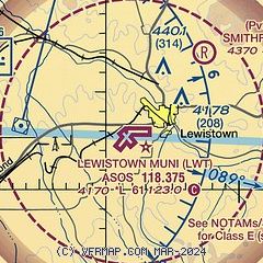
| Sectional chart |
|---|
|
| Airport distance calculator |
|---|
|
|
| Sunrise and sunset |
|---|
|
Times for 02-Mar-2026
| | Local
(UTC-7) | | Zulu
(UTC) |
|---|
| Morning civil twilight | | 06:26 | | 13:26 |
| Sunrise | | 06:57 | | 13:57 |
| Sunset | | 18:03 | | 01:03 |
| Evening civil twilight | | 18:34 | | 01:34 |
|
| Current date and time |
|---|
| Zulu (UTC) | 02-Mar-2026 19:10:15 |
|---|
| Local (UTC-7) | 02-Mar-2026 12:10:15 |
|---|
|
| METAR |
|---|
| KLWT | 021854Z AUTO 35005KT 10SM CLR 12/M07 A2989 RMK AO2 SLP132 T01171072
|
|
| TAF |
|---|
| KLWT | 021720Z 0218/0318 VRB04KT P6SM SCT250
|
|
| NOTAMs |
|---|
NOTAMs are issued by the DoD/FAA and will open in a separate window not controlled by AirNav.
|
|


