FAA INFORMATION EFFECTIVE 14 MAY 2026
Location
| FAA Identifier: | LZZ |
| Lat/Long: | 31-06-22.3000N 098-11-45.3000W
31-06.371667N 098-11.755000W
31.1061944,-98.1959167
(estimated) |
| Elevation: | 1214.4 ft. / 370.1 m (surveyed) |
| Variation: | 08E (1980) |
| From city: | 3 miles N of LAMPASAS, TX |
| Time zone: | UTC -5 (UTC -6 during Standard Time) |
| Zip code: | 76550 |
Airport Operations
| Airport use: | Open to the public |
| Activation date: | 12/1966 |
| Control tower: | no |
| ARTCC: | FORT WORTH CENTER |
| FSS: | SAN ANGELO FLIGHT SERVICE STATION |
| NOTAMs facility: | SJT (NOTAM-D service available) |
| Attendance: | UNATNDD
FOR ATTENDANT AFT HRS CALL AMGR. |
| Wind indicator: | lighted |
| Segmented circle: | yes |
| Lights: | ACTVT PAPI RWYS 16 & 34; MIRL RWY 16/34 - CTAF. |
| Beacon: | white-green (lighted land airport)
Operates sunset to sunrise. |
Airport Communications
| CTAF/UNICOM: | 122.8 |
| WX AWOS-3: | 119.075 (512-556-6392) |
| GRAY APPROACH: | 120.075 [1345-0600Z++ MON-THU; 1345-2345Z++ FRI; CLSD SAT, SUN AND HOL EXC BY NOTAM, HRS SUBJ TO CHG.] |
| GRAY DEPARTURE: | 120.075 [1345-0600Z++ MON-THU; 1345-2345Z++ FRI; CLSD SAT, SUN AND HOL EXC BY NOTAM, HRS SUBJ TO CHG.] |
Nearby radio navigation aids
| VOR radial/distance | | VOR name | | Freq | | Var |
|---|
| AGJr205/5.5 | | GOOCH SPRINGS VORTAC | | 112.50 | | 05E |
| GRKr276/20.1 | | GRAY VOR/DME | | 111.80 | | 07E |
Airport Services
| Fuel available: | 100LL
100LL:FUEL 24 HR SELF SVC. |
| Parking: | tiedowns |
| Bottled oxygen: | NONE |
| Bulk oxygen: | NONE |
Runway Information
Runway 16/34
| Dimensions: | 4202 x 75 ft. / 1281 x 23 m |
| Surface: | asphalt, in good condition |
| Weight bearing capacity: | |
| Runway edge lights: | medium intensity |
| RUNWAY 16 | | RUNWAY 34 |
| Latitude: | 31-06.713448N | | 31-06.029498N |
| Longitude: | 098-11.819947W | | 098-11.690182W |
| Elevation: | 1214.4 ft. | | 1156.4 ft. |
| Traffic pattern: | left | | left |
| Runway heading: | 163 magnetic, 171 true | | 343 magnetic, 351 true |
| Markings: | nonprecision, in good condition | | nonprecision, in good condition |
| Visual slope indicator: | 2-light PAPI on left (3.00 degrees glide path) | | 2-light PAPI on left (3.00 degrees glide path) |
| Touchdown point: | yes, no lights | | yes, no lights |
| Obstructions: | 20 ft. trees, 201 ft. from runway, 170 ft. right of centerline
6 FT GROUND, O FT DSTC, 124 FT R. 23 FT TREES, 0 FT DSTC, 208 R. | | none
12 FT BRUSH, 100-100 FT DSTC, 188L. |
Airport Ownership and Management from official FAA records
| Ownership: | Publicly-owned |
| Owner: | CITY OF LAMPASAS
312 E. 3RD STREET
LAMPASAS, TX 76550
Phone 512-556-6831 |
| Manager: | ROBERT LANSFORD
312 E. 3RD STREET
LAMPASAS, TX 76550
Phone 512-734-5634 |
Additional Remarks
Instrument Procedures
NOTE: All procedures below are presented as PDF files. If you need a reader for these files, you should download the free Adobe Reader.NOT FOR NAVIGATION. Please procure official charts for flight.
FAA instrument procedures published for use from 14 May 2026 at 0901Z to 11 June 2026 at 0900Z.
IAPs - Instrument Approach Procedures |
|---|
| RNAV (GPS) RWY 34 | |
download (186KB) |
| VOR-A | |
download (180KB) |
| NOTE: Special Alternate Minimums apply | |
download (138KB) |
| NOTE: Special Take-Off Minimums/Departure Procedures apply | |
download (105KB) |
Other nearby airports with instrument procedures:
KGRK - Robert Gray Army Airfield (19 nm E)
KBMQ - Burnet Municipal Airport/Kate Craddock Field (22 nm S)
KHLR - Yoakum-Defrenn Army Heliport (25 nm E)
KILE - Skylark Field Airport (26 nm E)
81R - San Saba County Municipal Airport (28 nm W)
|
|

Road maps at:
MapQuest
Bing
Google
| Aerial photo |
|---|
WARNING: Photo may not be current or correct
 Photo by Sue Mulhall
Photo taken 17-Jul-2020
looking south-southeast.
Photo by Sue Mulhall
Photo taken 17-Jul-2020
looking south-southeast.
Do you have a better or more recent aerial photo of Lampasas Airport that you would like to share? If so, please send us your photo.
|
| Sectional chart |
|---|
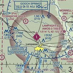
|
| Airport distance calculator |
|---|
|
|
| Sunrise and sunset |
|---|
|
Times for 15-May-2026
| | Local
(UTC-5) | | Zulu
(UTC) |
|---|
| Morning civil twilight | | 06:12 | | 11:12 |
| Sunrise | | 06:38 | | 11:38 |
| Sunset | | 20:20 | | 01:20 |
| Evening civil twilight | | 20:47 | | 01:47 |
|
| Current date and time |
|---|
| Zulu (UTC) | 15-May-2026 17:56:03 |
|---|
| Local (UTC-5) | 15-May-2026 12:56:03 |
|---|
|
| METAR |
|---|
| KLZZ | 151735Z AUTO 18008G15KT 10SM CLR 25/17 A2992 RMK AO2
|
KGRK
19nm E | 151655Z AUTO 17012G18KT 10SM BKN160 27/19 A2992 RMK AO2 SLP121 T02690190
|
|
| TAF |
|---|
KGRK
19nm E | 151600Z 1516/1622 17015G22KT 9999 SCT180 BKN250 510505 QNH2982INS BECMG 1523/1524 16010G18KT 9999 FEW250 QNH2979INS BECMG 1610/1611 17012G22KT 9999 SCT015 OVC025 QNH2986INS BECMG 1614/1615 18015G25KT 9999 SCT025 QNH2978INS TX30/1521Z TN21/1610Z
|
|
| NOTAMs |
|---|
NOTAMs are issued by the DoD/FAA and will open in a separate window not controlled by AirNav.
|
|

