FAA INFORMATION EFFECTIVE 19 MARCH 2026
Location
| FAA Identifier: | NFL |
| Lat/Long: | 39-25-04.1900N 118-41-54.9180W
39-25.069833N 118-41.915300W
39.4178306,-118.6985883
(estimated) |
| Elevation: | 3934.8 ft. / 1199.3 m (surveyed) |
| Variation: | 14E (2010) |
| From city: | 3 miles NE of FALLON, NV |
| Time zone: | UTC -7 (UTC -8 during Standard Time) |
| Zip code: | 89496 |
Airport Operations
| Airport use: | Private use. Permission required prior to landing |
| Activation date: | 12/1942 |
| Control tower: | yes |
| ARTCC: | OAKLAND CENTER |
| FSS: | RENO FLIGHT SERVICE STATION |
| NOTAMs facility: | NFL (NOTAM-D service available) |
| Attendance: | MON-FRI 1530-0700Z, ALL SAT 1800-0200Z++, ALL SUN 2000-0200Z++
CLSD HOL; OTR TIMES BY NOTAM. |
| Pattern altitude: | INITIAL ALL RWY 7600 FT; OVERHEAD BREAK 5500 FT; NO OVERHEAD FOR RWY 07; PAT ALT 5000 FT. |
| Segmented circle: | no |
| Lights: | AVBL DURG OPS HRS. |
| Beacon: | white-white-green (lighted military airport)
Operates sunset to sunrise. |
Airport Communications
| ATIS: | 370.925 |
| NAVY FALLON GROUND: | 251.15 [1530-0700Z++ MON-FRI, SAT 1800-0200Z++, SUN 2000-0200Z++, CLDS HOL, OT BY NOTAM] |
| NAVY FALLON TOWER: | 119.25 340.2 [1530-0700Z++ MON-FRI, SAT 1800-0200Z++, SUN 2000-0200Z++, CLDS HOL, OT BY NOTAM] |
| NAVY FALLON APPROACH: | 120.85 360.2 [SAME AS TWR HRS] |
| NAVY FALLON DEPARTURE: | 120.85 360.2 [SAME AS TWR HRS] |
| CLEARANCE DELIVERY: | 353.55 |
| BASE OPS: | 238.0 328.0 |
| OPS: | 322.35 ;DESERT CONTROL |
| PMSV METRO: | 327.4 |
| WX AWOS-AV at FLX (5 nm NW): | 118.25 (775-423-2201) |
- APCH/DEP CTL SVC PRVDD BY OAKLAND ARTCC (ZOA) ON FREQS 128.8/285.5 (FALLON RCAG) WHEN FALLON APCH CTL (NFL) CLSD.
- SFA.
Nearby radio navigation aids
| VOR radial/distance | | VOR name | | Freq | | Var |
|---|
| HZNr096/15.1 | | HAZEN VORTAC | | 114.10 | | 17E |
Airport Services
Runway Information
Runway 13R/31L
| Dimensions: | 14001 x 201 ft. / 4268 x 61 m |
| Surface: | asphalt |
| Weight bearing capacity: | | PCN 59 /R/C/W/T | | Double wheel: | ALSO ST154. |
|
| Runway edge lights: | high intensity |
| Operational restrictions: | LRG MULTI ENG; FSL/TGL RWY 31; LND PAST BI-DRCTNL (E28) ARRESTING GEAR 1892 FT FM AER. |
| RUNWAY 13R | | RUNWAY 31L |
| Latitude: | 39-26.135333N | | 39-24.242000N |
| Longitude: | 118-42.837667W | | 118-41.139833W |
| Elevation: | 3934.8 ft. | | 3926.8 ft. |
| Traffic pattern: | left | | left |
| Runway heading: | 131 magnetic, 145 true | | 311 magnetic, 325 true |
| Markings: | precision, in good condition | | precision, in good condition |
| Visual slope indicator: | 4-light PAPI on left (3.00 degrees glide path)
PAPI 13R UNUSBL BYD 5 DEG EACH SIDE OF CNTRLN. | | 4-light PAPI on left (3.50 degrees glide path)
PAPI 31L UNUSBL BYD 5 DEG EACH SIDE OF CNTRLN. |
| Touchdown point: | yes, no lights | | yes, no lights |
Runway 13L/31R
| Dimensions: | 11076 x 200 ft. / 3376 x 61 m |
| Surface: | concrete |
| Weight bearing capacity: | |
| Runway edge lights: | high intensity |
| RUNWAY 13L | | RUNWAY 31R |
| Latitude: | 39-25.833833N | | 39-24.336000N |
| Longitude: | 118-42.308500W | | 118-40.965333W |
| Elevation: | 3934.7 ft. | | 3926.7 ft. |
| Traffic pattern: | left | | left |
| Runway heading: | 131 magnetic, 145 true | | 311 magnetic, 325 true |
| Markings: | precision, in good condition | | precision, in good condition |
| Visual slope indicator: | 4-light PAPI on right (3.00 degrees glide path) | | 4-light PAPI on left (3.50 degrees glide path) |
| Touchdown point: | yes, no lights | | yes, no lights |
Runway 7/25
| Dimensions: | 7003 x 152 ft. / 2135 x 46 m |
| Surface: | asphalt |
| Weight bearing capacity: | |
| Runway edge lights: | high intensity |
| RUNWAY 7 | | RUNWAY 25 |
| Latitude: | 39-24.786333N | | 39-24.829933N |
| Longitude: | 118-42.952333W | | 118-41.466417W |
| Elevation: | 3929.0 ft. | | 3926.7 ft. |
| Traffic pattern: | left | | left |
| Runway heading: | 074 magnetic, 088 true | | 254 magnetic, 268 true |
| Markings: | precision, in good condition | | basic, in good condition |
| Touchdown point: | yes, no lights | | yes, no lights |
Airport Ownership and Management from official FAA records
| Ownership: | U.S. Navy |
| Owner: | US NAVY
OCEANOGRAPHIC OFC - CODE 3142
WASHINGTON, DC 20373
ROWDY YATES 775-426-2427. |
| Manager: | COMMANDING OFFICER
NAVAL AIR STATION
FALLON, NV 89406
Phone 775-426-2419
RATCF - 775-426-2590. |
Additional Remarks
| E60-25 | HOOK E28(B) (1290 FT). |
| E60-07 | HOOK E28(B) (1300 FT). |
| E60-13L | HOOK E28(B) (952 FT). |
| E60-31R | HOOK E28(B) (951 FT). |
| E60-31L | HOOK E28(B) (1893 FT). |
| E60-13R | HOOK E28(B) (1804 FT). |
| - | A-GEAR: E-28(B) APCH END ON PARALLEL RWYS NML DERIGGED. |
| - | TFC PAT: ACTVT LDG/TAXI LGT ON APCH. RDC RWY SEPN STD IN EFCT FOR USN/USMCFT. |
| - | MISC: BASE OPS D890-2419/2458/C775-426-2419/2458. |
| - | MISC: PPR TO SKED FRTC AIRSPACE AFT AIRFIELD HRS - NAS FALLON OPS OFFICER APVL EXTD AIRFIELD HRS. |
| - | FUEL: A++; 4 HR PN RQR FOR ACFT REQ HOT REFUEL, REQ INVLD AFTER 30 MIN, DSN 890-3461/3481 C775-426-2508/9. |
| - | CTN: 126 FT RADAR DOME 1.1 NM SW OF ATCT. TWY C, S APN TO RWY 25 APCH END VRBL WID TAPERING TO 50 FT E OF RWY 13R-31L. |
| - | NOISE ABATEMENT: DEP RWY 31L/R VFR TURN RIGHT HDG 040 OVER DEP END. DESELECT AFTERBURNER AT EOR & CLB AS QUICKLY AS PSBL. |
| - | CTN: HVY MIL TRNG OPS ALL HRS. |
| - | MISC: RWY 13L/31R TGL OVR 100000 LB NA. |
| - | MISC: CLASS D AIRSPACE REVERTS TO CLASS E WHEN TWR CLSD; WHEN TWR OPEN, CLASS E AIRSPACE REVERTS TO CLASS D. |
| - | JASU: 1(GTC-85) 1(NCPP-105) 2(NC-8A). |
| - | RSTD: ALL CIV ACFT MUST HAVE CURRENT CALP AND MEET ALL RQRMTS. CALP POC IS NASF ODO LCTD IN BLDG 301 AT C775-426-2419. |
| - | DEPLOYING SQDNS/CVW CTC SCHEDULER DSN 890-2545 C775-426-2545. |
| - | FLUID: SP LOX. |
| - | TRAN ALERT: NO TSNT MAINT/HGR SPACE OR DE-ICE AVBL. |
| - | SEE FLIP AP/1 SUPPLEMENTARY ARPT RMK. |
| - | RSTD: PPR 24 HR IN ADVN FOR TSNT SVC EXC MEDEVAC, SAR, SKED L FLT. PPR VALID 4 HR BYD ETA UNLESS RESKED - DSN 890-3549, C775-426-3549. |
| - | CTN: BIRD ACT WI 15 NM SFC - 3000 FT. GA OPS FM FALLON MUNI 5 NM NNW. |
Instrument Procedures
NOTE: All procedures below are presented as PDF files. If you need a reader for these files, you should download the free Adobe Reader.NOT FOR NAVIGATION. Please procure official charts for flight.
FAA instrument procedures published for use from 19 March 2026 at 0901Z to 16 April 2026 at 0900Z.
IAPs - Instrument Approach Procedures |
|---|
| RNAV (GPS) RWY 13R | |
download (87KB) |
| RNAV (GPS) RWY 25 | |
download (117KB) |
| RNAV (GPS) RWY 31L | |
download (125KB) |
| HI-TACAN Z RWY 13R | |
download (132KB) |
| HI-TACAN Z RWY 31L/R | |
download (152KB) |
| TACAN RWY 25 | |
download (124KB) |
| TACAN Y RWY 13R | |
download (127KB) |
| TACAN Y RWY 31L/R | |
download (143KB) |
| Radar Approach Procedures available | |
download (131KB) |
Departure Procedures |
|---|
| FALLON ONE | |
download (112KB) |
| YERIN EIGHT | |
download (129KB) |
| NOTE: Special Take-Off Minimums/Departure Procedures apply | |
download (390KB) |
Other nearby airports with instrument procedures:
KFLX - Fallon Municipal Airport (5 nm NW)
KSPZ - Silver Springs Airport (26 nm W)
O43 - Yerington Municipal Airport (33 nm SW)
KLOL - Derby Field Airport (39 nm N)
KRNO - Reno/Tahoe International Airport (50 nm W)
|
|

Road maps at:
MapQuest
Bing
Google
| Aerial photo |
|---|
WARNING: Photo may not be current or correct
 Taken in the Fall of 2005
Do you have a better or more recent aerial photo of Fallon Naval Air Station (Van Voorhis Field) Airport that you would like to share? If so, please send us your photo.
|
| Sectional chart |
|---|
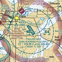
|
| Airport distance calculator |
|---|
|
|
| Sunrise and sunset |
|---|
|
Times for 01-Apr-2026
| | Local
(UTC-7) | | Zulu
(UTC) |
|---|
| Morning civil twilight | | 06:13 | | 13:13 |
| Sunrise | | 06:40 | | 13:40 |
| Sunset | | 19:17 | | 02:17 |
| Evening civil twilight | | 19:45 | | 02:45 |
|
| Current date and time |
|---|
| Zulu (UTC) | 02-Apr-2026 00:43:41 |
|---|
| Local (UTC-7) | 01-Apr-2026 17:43:41 |
|---|
|
| METAR |
|---|
| KNFL | 012357Z 23018G29KT 10SM SCT050 BKN080 BKN120 BKN150 16/M02 A2973 RMK AO2 PK WND 23032/2305 SLP048 ACSL DSNT ALQDS T01611017 10194 20139 56009 PNO $
|
|
| TAF |
|---|
| KNFL | 0123/0223 25022G36KT 9999 VCSH SCT050 BKN100 BKN150 BKN200 530009 530906 561509 QNH2971INS FM020300 26018G30KT 9999 SCT050 SCT100 BKN150 BKN180 530009 530906 561509 QNH2969INS FM020700 30015G25KT 9999 SCT050 SCT100 BKN150 BKN180 520009 530906 541509 QNH2970INS FM021500 31021G34KT 9999 FEW050 SCT100 SCT150 SCT180 520009 530906 541509 QNH2990INS AUTOMATED SENSOR METWATCH TX17/0120Z TN04/0213Z FS30198
|
|
| NOTAMs |
|---|
NOTAMs are issued by the DoD/FAA and will open in a separate window not controlled by AirNav.
|
|

