FAA INFORMATION EFFECTIVE 19 MARCH 2026
Location
| FAA Identifier: | OTH |
| Lat/Long: | 43-25-01.0000N 124-14-49.3000W
43-25.016667N 124-14.821667W
43.4169444,-124.2470278
(estimated) |
| Elevation: | 17.4 ft. / 5.3 m (surveyed) |
| Variation: | 15E (2020) |
| From city: | 1 mile NW of NORTH BEND, OR |
| Time zone: | UTC -7 (UTC -8 during Standard Time) |
| Zip code: | 97459 |
Airport Operations
| Airport use: | Open to the public |
| Activation date: | 01/1940 |
| Control tower: | yes |
| ARTCC: | SEATTLE CENTER |
| FSS: | MC MINNVILLE FLIGHT SERVICE STATION |
| NOTAMs facility: | OTH (NOTAM-D service available) |
| Attendance: | 0500-2100
AFT HR - 541-756-5181. |
| Wind indicator: | lighted |
| Segmented circle: | yes |
| Lights: | WHEN ATCT CLSD, ACTVT MALSR RWY 05; REIL RWYS 13, 23, 31; MIRL RWY 13/31; HIRL 05/23 - CTAF. PAPI RWY 05 OPR CONSLY. |
| Beacon: | white-green (lighted land airport)
Operates sunset to sunrise. |
| Landing fee: | yes |
| Fire and rescue: | ARFF index A |
| Airline operations: | INDEX B AVBL WITH 4 HR PPR - 541-297-4777. |
Airport Communications
| CTAF: | 118.45 |
| WX AWOS-3PT: | 135.075 (541-756-0135) |
| NORTH BEND GROUND: | 127.1 [0700-2100] |
| NORTH BEND TOWER: | 118.45 [0700-2100] |
- APCH/DEP CTL SVC PRVDD BY SEATTLE ARTCC (ZSE) ON FREQS 127.55/254.35 (HORTON RCAG).
Nearby radio navigation aids
| VOR radial/distance | | VOR name | | Freq | | Var |
|---|
| OTHr256/3.4 | | NORTH BEND VOR/DME | | 113.85 | | 15E |
Airport Services
| Fuel available: | 100LL JET-A |
| Parking: | hangars and tiedowns |
| Airframe service: | MAJOR |
| Powerplant service: | MAJOR |
Runway Information
Runway 5/23
| Dimensions: | 5980 x 150 ft. / 1823 x 46 m |
| Surface: | asphalt/grooved, in good condition |
| Weight bearing capacity: | | Single wheel: | 120.0 | | Double wheel: | 215.0 | | Double tandem: | 340.0 | | Dual double tandem: | 800.0 |
|
| Runway edge lights: | high intensity |
| RUNWAY 5 | | RUNWAY 23 |
| Latitude: | 43-24.883747N | | 43-25.365883N |
| Longitude: | 124-15.635873W | | 124-14.458542W |
| Elevation: | 16.1 ft. | | 13.4 ft. |
| Traffic pattern: | left | | left |
| Runway heading: | 046 magnetic, 061 true | | 226 magnetic, 241 true |
| Displaced threshold: | no | | 660 ft. |
| Declared distances: | TORA:5320 TODA:5320 ASDA:5320 LDA:5320 | | TORA:5980 TODA:5980 ASDA:5980 LDA:5320 |
| Markings: | precision, in fair condition | | precision, in fair condition |
| Visual slope indicator: | 4-light PAPI on right (3.00 degrees glide path) | | |
| Approach lights: | MALSR: 1,400 foot medium intensity approach lighting system with runway alignment indicator lights | | |
| Runway end identifier lights: | no | | yes |
| Touchdown point: | yes, no lights | | yes, no lights |
| Instrument approach: | ILS/DME | | |
| Obstructions: | 144 ft. boat, 3700 ft. from runway, 25:1 slope to clear | | 144 ft. boat, 1320 ft. from runway, 550 ft. right of centerline, 8:1 slope to clear |
Runway 13/31
| Dimensions: | 4470 x 150 ft. / 1362 x 46 m |
| Surface: | asphalt/grooved, in good condition |
| Weight bearing capacity: | | Single wheel: | 120.0 | | Double wheel: | 190.0 | | Double tandem: | 305.0 | | Dual double tandem: | 735.0 |
|
| Runway edge lights: | medium intensity |
| RUNWAY 13 | | RUNWAY 31 |
| Latitude: | 43-25.190493N | | 43-24.555630N |
| Longitude: | 124-14.774332W | | 124-14.264093W |
| Elevation: | 13.1 ft. | | 17.4 ft. |
| Traffic pattern: | left | | right |
| Runway heading: | 135 magnetic, 150 true | | 315 magnetic, 330 true |
| Declared distances: | TORA:4470 TODA:4470 ASDA:4470 LDA:4470 | | TORA:4470 TODA:4470 ASDA:4470 LDA:4470 |
| Markings: | basic, in good condition | | basic, in good condition |
| Visual slope indicator: | | | 4-light PAPI on left (4.00 degrees glide path)
P4L OTS INDEFLY. |
| Runway end identifier lights: | yes | | yes |
| Touchdown point: | yes, no lights | | yes, no lights |
| Obstructions: | 144 ft. boat, 1740 ft. from runway, 11:1 slope to clear | | 13 ft. road, 200 ft. from runway, 250 ft. right of centerline |
Airport Ownership and Management from official FAA records
| Ownership: | Publicly-owned |
| Owner: | COOS COUNTY AIRPORT DISTRICT
1100 AIRPORT LANE, FLOOR 3
NORTH BEND, OR 97459-2079
Phone 541-756-8500 |
| Manager: | RODGER CRADDOCK
1100 AIRPORT LANE, FLOOR 3
NORTH BEND, OR 97459-2079
Phone 541-756-8531 |
Additional Remarks
| A39-05/23 | PCR VALUE: 398/F/A/X/T |
| A39-13/31 | PCR VALUE: 124/F/A/X/T |
| - | SHIP CHNL XS RWY 05 2/3 MI FM THLD; XS RWY 13 & RWY 23 1000 - 1700 FT FM THLD; MAST HGTS TO 144 FT. |
| - | WATERFOWL ON & INVOF ARPT. |
| - | ARPT USE FEES. |
| - | PAEW INVOF RWYS & TWYS 0730-1530. |
| - | TWY A3 CLSD OVR 60000 LB. |
| - | FOR CD IF UNA TO CTC ON FSS FREQ, CTC SEATTLE ARTCC AT 253-351-3694. |
| - | PILOTS CONDUCTING EFVS OPS; BE AWARE LED ALS IN USE RWY 05. |
Instrument Procedures
NOTE: All procedures below are presented as PDF files. If you need a reader for these files, you should download the free Adobe Reader.NOT FOR NAVIGATION. Please procure official charts for flight.
FAA instrument procedures published for use from 19 March 2026 at 0901Z to 16 April 2026 at 0900Z.
IAPs - Instrument Approach Procedures |
|---|
| ILS Z OR LOC Z RWY 05 | |
download (271KB) |
| RNAV (RNP) Z RWY 05 | |
download (305KB) |
| RNAV (GPS) Y RWY 05 | |
download (269KB) |
| VOR-B | |
download (217KB) |
| COPTER ILS Y OR LOC Y RWY 05 | |
download (258KB) |
| NOTE: Special Alternate Minimums apply | |
download (212KB) |
Departure Procedures |
|---|
| NORTH BEND SEVEN | |
download (223KB) |
| NOTE: Special Take-Off Minimums/Departure Procedures apply | |
download (647KB) |
Other nearby airports with instrument procedures:
KRBG - Roseburg Regional Airport (40 nm E)
4S1 - Gold Beach Municipal Airport (61 nm S)
KEUG - Mahlon Sweet Field Airport (62 nm NE)
77S - Hobby Field Airport (62 nm NE)
3S8 - Grants Pass Airport (66 nm SE)
|
|

Road maps at:
MapQuest
Bing
Google
| Aerial photo |
|---|
WARNING: Photo may not be current or correct

Do you have a better or more recent aerial photo of Southwest Oregon Regional Airport that you would like to share? If so, please send us your photo.
|
| Sectional chart |
|---|
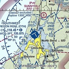
|
| Airport distance calculator |
|---|
|
|
| Sunrise and sunset |
|---|
|
Times for 11-Apr-2026
| | Local
(UTC-7) | | Zulu
(UTC) |
|---|
| Morning civil twilight | | 06:13 | | 13:13 |
| Sunrise | | 06:42 | | 13:42 |
| Sunset | | 19:54 | | 02:54 |
| Evening civil twilight | | 20:23 | | 03:23 |
|
| Current date and time |
|---|
| Zulu (UTC) | 12-Apr-2026 05:57:36 |
|---|
| Local (UTC-7) | 11-Apr-2026 22:57:36 |
|---|
|
| METAR |
|---|
| KOTH | 112356Z 10003KT 10SM OVC085 12/11 A2970
|
|
| TAF |
|---|
| KOTH | 111743Z 1118/1218 24005KT P6SM -SHRA SCT015 OVC025 FM112200 29007KT P6SM VCSH SCT025 OVC050 FM120700 VRB03KT P6SM -SHRA OVC025 FM121000 VRB03KT 5SM -SHRA BR OVC010 AMD NOT SKED
|
|
| NOTAMs |
|---|
NOTAMs are issued by the DoD/FAA and will open in a separate window not controlled by AirNav.
|
|

