FAA INFORMATION EFFECTIVE 11 JUNE 2026
Location
| FAA Identifier: | PBH |
| Lat/Long: | 45-42-31.8000N 090-24-09.0000W
45-42.530000N 090-24.150000W
45.7088333,-90.4025000
(estimated) |
| Elevation: | 1497.1 ft. / 456.3 m (surveyed) |
| Variation: | 00E (1985) |
| From city: | 1 mile NW of PHILLIPS, WI |
| Time zone: | UTC -5 (UTC -6 during Standard Time) |
| Zip code: | 54555 |
Airport Operations
| Airport use: | Open to the public |
| Activation date: | 05/1945 |
| Control tower: | no |
| ARTCC: | MINNEAPOLIS CENTER |
| FSS: | GREEN BAY FLIGHT SERVICE STATION |
| NOTAMs facility: | PBH (NOTAM-D service available) |
| Attendance: | MON-FRI 0800-1630 |
| Wind indicator: | lighted |
| Segmented circle: | yes |
| Lights: | MIRL RWY 01/19 PRESET TO LOW SS-SR; TO INCR INTST & ACTVT REIL RWY 01, 19 & 24; PAPI RWY 01 & 19; VASI RWY 06 & 24; MIRL RWY 06/24 - CTAF. |
| Beacon: | white-green (lighted land airport)
Operates sunset to sunrise. |
Airport Communications
| CTAF/UNICOM: | 122.8 |
| WX AWOS-3: | 125.875 (715-339-4520) |
- APCH/DEP SVC PRVDD BY MINNEAPOLIS ARTCC ON FREQS 133.65/281.5 (RHINELANDER RCAG).
Nearby radio navigation aids
| VOR radial/distance | | VOR name | | Freq | | Var |
|---|
| RHIr274/39.9 | | RHINELANDER VOR/DME | | 115.05 | | 02E |
Airport Services
| Fuel available: | 100LL JET-A+ UL91
100LL:FUEL AVBL 24 HRS WITH CREDIT CARD. |
| Parking: | tiedowns |
| Airframe service: | MAJOR |
| Powerplant service: | NONE |
| Bottled oxygen: | NONE |
| Bulk oxygen: | NONE |
Runway Information
Runway 1/19
| Dimensions: | 5220 x 75 ft. / 1591 x 23 m |
| Surface: | asphalt, in excellent condition |
| Weight bearing capacity: | |
| Runway edge lights: | medium intensity |
| RUNWAY 1 | | RUNWAY 19 |
| Latitude: | 45-42.257232N | | 45-43.109693N |
| Longitude: | 090-24.208517W | | 090-24.058668W |
| Elevation: | 1464.9 ft. | | 1497.0 ft. |
| Traffic pattern: | left | | left |
| Runway heading: | 007 | | 187 |
| Markings: | nonprecision, in good condition | | nonprecision, in good condition |
| Visual slope indicator: | 2-light PAPI on left (3.00 degrees glide path) | | 2-light PAPI on left (3.00 degrees glide path) |
| Runway end identifier lights: | yes | | yes |
| Touchdown point: | yes, no lights | | yes, no lights |
| Obstructions: | 58 ft. trees, 1850 ft. from runway, 300 ft. right of centerline, 28:1 slope to clear | | none |
Runway 6/24
| Dimensions: | 3951 x 75 ft. / 1204 x 23 m |
| Surface: | asphalt, in good condition |
| Weight bearing capacity: | | Single wheel: | 28.0 | | Double wheel: | 40.0 |
|
| Runway edge lights: | medium intensity |
| RUNWAY 6 | | RUNWAY 24 |
| Latitude: | 45-42.160763N | | 45-42.495827N |
| Longitude: | 090-24.570392W | | 090-23.775210W |
| Elevation: | 1465.4 ft. | | 1472.0 ft. |
| Traffic pattern: | left | | left |
| Runway heading: | 059 | | 239 |
| Markings: | nonprecision, in fair condition | | nonprecision, in fair condition |
| Visual slope indicator: | 2-box VASI on left (4.00 degrees glide path) | | 2-box VASI on left (3.00 degrees glide path) |
| Runway end identifier lights: | | | yes |
| Touchdown point: | yes, no lights | | yes, no lights |
| Obstructions: | none | | 110 ft. trees, 2070 ft. from runway, 35 ft. left of centerline, 17:1 slope to clear |
Airport Ownership and Management from official FAA records
| Ownership: | Publicly-owned |
| Owner: | PRICE COUNTY
126 CHERRY ST.
PHILLIPS, WI 54555
Phone 715-339-3325 |
| Manager: | MICHAEL BRILL
N1215 AIRPORT RD
PHILLIPS, WI 54555
Phone 715-339-3701 |
Additional Remarks
| - | BIRDS ON & INVOF ARPT. |
| - | FOR CD IF UNA TO CTC ON FSS FREQ, CTC MINNEAPOLIS ARTCC AT 651-463-5588. |
Instrument Procedures
NOTE: All procedures below are presented as PDF files. If you need a reader for these files, you should download the free Adobe Reader.NOT FOR NAVIGATION. Please procure official charts for flight.
FAA instrument procedures published for use from 11 June 2026 at 0901Z to 09 July 2026 at 0900z.
IAPs - Instrument Approach Procedures |
|---|
| RNAV (GPS) RWY 01 | |
download (219KB) |
| RNAV (GPS) RWY 06 | |
download (236KB) |
| RNAV (GPS) RWY 19 | |
download (262KB) |
| RNAV (GPS) RWY 24 | |
download (246KB) |
| NOTE: Special Alternate Minimums apply | |
download (141KB) |
| NOTE: Special Take-Off Minimums/Departure Procedures apply | |
download (384KB) |
Other nearby airports with instrument procedures:
KPKF - Park Falls Municipal Airport (15 nm N)
KRCX - Rusk County Airport (28 nm SW)
KTKV - Tomahawk Regional Airport (29 nm SE)
KARV - Lakeland Airport/Noble F. Lee Memorial Field (31 nm NE)
D25 - Manitowish Waters Airport (33 nm NE)
|
|

Road maps at:
MapQuest
Bing
Google
| Aerial photo |
|---|
WARNING: Photo may not be current or correct
 Photo by Greg Teeters
Photo taken 08-Oct-2017
looking northeast.
Photo by Greg Teeters
Photo taken 08-Oct-2017
looking northeast.
Do you have a better or more recent aerial photo of Price County Airport that you would like to share? If so, please send us your photo.
|
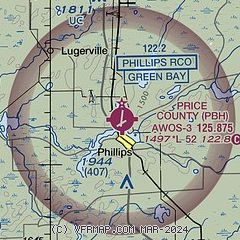
| Sectional chart |
|---|
|
| Airport distance calculator |
|---|
|
|
| Sunrise and sunset |
|---|
|
Times for 11-Jun-2026
| | Local
(UTC-5) | | Zulu
(UTC) |
|---|
| Morning civil twilight | | 04:35 | | 09:35 |
| Sunrise | | 05:13 | | 10:13 |
| Sunset | | 20:50 | | 01:50 |
| Evening civil twilight | | 21:28 | | 02:28 |
|
| Current date and time |
|---|
| Zulu (UTC) | 12-Jun-2026 04:02:56 |
|---|
| Local (UTC-5) | 11-Jun-2026 23:02:56 |
|---|
|
| METAR |
|---|
| KPBH | 120355Z AUTO 27004KT 10SM BKN080 BKN120 14/13 A2966 RMK AO2 T01360131
|
|
| TAF |
|---|
KRHI
39nm E | 112359Z 1200/1224 34008G16KT 3SM SHRA SCT020 FM120200 31008G17KT 3SM SHRA BR OVC021 FM120600 27008G16KT P6SM BKN022 FM120900 26008G16KT P6SM BKN014 FM121100 26008G15KT P6SM SCT012 FM121300 26012G21KT P6SM SCT080
|
KHYR
48nm NW | 111937Z 1120/1218 19009KT P6SM -SHRA OVC100 FM120400 25006KT P6SM BKN030 FM120500 26007KT P6SM SCT060 FM121400 26015G27KT P6SM SCT190
|
|
| NOTAMs |
|---|
NOTAMs are issued by the DoD/FAA and will open in a separate window not controlled by AirNav.
|
|

