FAA INFORMATION EFFECTIVE 11 JUNE 2026
Location
| FAA Identifier: | PBX |
| Lat/Long: | 37-33-42.5212N 082-33-59.1551W
37-33.708687N 082-33.985918W
37.5618114,-82.5664320
(estimated) |
| Elevation: | 1464.5 ft. / 446.4 m (surveyed) |
| Variation: | 07W (2020) |
| From city: | 6 miles NW of PIKEVILLE, KY |
| Time zone: | UTC -4 (UTC -5 during Standard Time) |
| Zip code: | 41501 |
Airport Operations
| Airport use: | Open to the public |
| Activation date: | 03/1983 |
| Control tower: | no |
| ARTCC: | INDIANAPOLIS CENTER |
| FSS: | LOUISVILLE FLIGHT SERVICE STATION |
| NOTAMs facility: | LOU (NOTAM-D service available) |
| Attendance: | SAT-SUN 0900-1900, ALL MON-FRI 0800-2000
SVC AFT HR - AMGR.
WINTER HR MON-FRI 0800-1900. |
| Wind indicator: | lighted |
| Segmented circle: | yes |
| Lights: | ACTVT REIL RWY 09 & 27; PAPI RWY 09 & 27; HIRL RWY 09/27 - CTAF. |
| Beacon: | white-green (lighted land airport)
Operates sunset to sunrise. |
Airport Communications
| CTAF/UNICOM: | 122.8 |
| WX AWOS-3PT: | 121.225 (606-437-6701) |
| WX AWOS-3 at SJS (12 nm N): | 120.175 (606-298-4143) |
- APCH/DEP SVC PRVDD BY INDIANAPOLIS ARTCC ON FREQS 126.575/257.850 (LYNCH RCAG).
Airport Services
| Fuel available: | 100LL JET-A+ |
| Parking: | tiedowns |
Runway Information
Runway 9/27
| Dimensions: | 5356 x 100 ft. / 1633 x 30 m |
| Surface: | asphalt, in good condition
MULT DIPS IN RWY. |
| Weight bearing capacity: | | PCN 5 /F/D/X/T | | Single wheel: | 30.0 |
|
| Runway edge lights: | high intensity |
| RUNWAY 9 | | RUNWAY 27 |
| Latitude: | 37-33.619020N | | 37-33.666398N |
| Longitude: | 082-34.756985W | | 082-33.649963W |
| Elevation: | 1448.1 ft. | | 1464.4 ft. |
| Traffic pattern: | left | | left |
| Runway heading: | 094 magnetic, 087 true | | 274 magnetic, 267 true |
| Displaced threshold: | 350 ft. | | 350 ft. |
| Declared distances: | TORA:5350 TODA:5350 ASDA:5000 LDA:4650 | | TORA:5350 TODA:5350 ASDA:5000 LDA:4650 |
| Markings: | nonprecision, in fair condition | | precision, in fair condition |
| Visual slope indicator: | 4-light PAPI on left (3.00 degrees glide path)
PAPI UNUSBL BYD 8 DEG RIGHT OF CNTRLN. | | 4-light PAPI on left (3.00 degrees glide path) |
| Runway end identifier lights: | yes | | yes |
| Touchdown point: | yes, no lights | | yes, no lights |
| Instrument approach: | | | ILS/DME |
| Obstructions: | 10 ft. tree, 204 ft. from runway, 279 ft. left of centerline
CONTROLLING OBSTN EXCEEDS A 45 DEG SLP. | | 30 ft. tree, 379 ft. from runway, 359 ft. right of centerline, 5:1 slope to clear
APCH RATIO 43:1 TO DTHR |
Runway 2/20
| Dimensions: | 3455 x 75 ft. / 1053 x 23 m |
| Surface: | asphalt/L |
| Weight bearing capacity: | | PCN 5 /F/D/X/T | | Single wheel: | 13.5 |
|
| Operational restrictions: | CLSD INDEFLY. |
| RUNWAY 2 | | RUNWAY 20 |
| Latitude: | 37-33.537433N | | 37-34.084508N |
| Longitude: | 082-33.747432W | | 082-33.549872W |
| Elevation: | 1470.2 ft. | | 1458.4 ft. |
| Traffic pattern: | left | | left |
| Runway heading: | 023 magnetic, 016 true | | 203 magnetic, 196 true |
| Runway end identifier lights: | no | | no |
| Touchdown point: | yes, no lights | | yes, no lights |
Airport Ownership and Management from official FAA records
| Ownership: | Publicly-owned |
| Owner: | PIKE COUNTY REG ARPT BOARD
P.O. BOX 3353
PIKEVILLE, KY 41502
Phone 606-432-5777
BILL HICKMAN. |
| Manager: | MATT RAY
331 AIRPORT DRIVE
PIKEVILLE, KY 41501
Phone 606-437-9548 |
Additional Remarks
| - | FOR CD IF UNA TO CTC ON FSS FREQ, CTC INDIANAPOLIS ARTCC AT 317-247-2411. |
Instrument Procedures
NOTE: All procedures below are presented as PDF files. If you need a reader for these files, you should download the free Adobe Reader.NOT FOR NAVIGATION. Please procure official charts for flight.
FAA instrument procedures published for use from 11 June 2026 at 0901Z to 09 July 2026 at 0900z.
IAPs - Instrument Approach Procedures |
|---|
| ILS OR LOC RWY 27 | |
download (225KB) |
| RNAV (GPS) RWY 09 | |
download (230KB) |
| RNAV (GPS) RWY 27 | |
download (209KB) |
| NOTE: Special Alternate Minimums apply | |
download (144KB) |
| NOTE: Special Take-Off Minimums/Departure Procedures apply | |
download (362KB) |
Other nearby airports with instrument procedures:
KSJS - Big Sandy Regional Airport (12 nm N)
KEBD - Southern West Virginia Regional Airport (22 nm E)
KLNP - Lonesome Pine Airport (34 nm S)
KCPF - Wendell H Ford Airport (35 nm W)
6L4 - Logan County Airport (36 nm NE)
|
|

Road maps at:
MapQuest
Bing
Google
| Aerial photo |
|---|
WARNING: Photo may not be current or correct
 Photo courtesy of Kentucky Coal Association
Taken in 2007
Photo courtesy of Kentucky Coal Association
Taken in 2007
Do you have a better or more recent aerial photo of Pike County Airport-Hatcher Field that you would like to share? If so, please send us your photo.
|
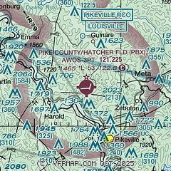
| Sectional chart |
|---|
|
| Airport distance calculator |
|---|
|
|
| Sunrise and sunset |
|---|
|
Times for 16-Jun-2026
| | Local
(UTC-4) | | Zulu
(UTC) |
|---|
| Morning civil twilight | | 05:38 | | 09:38 |
| Sunrise | | 06:09 | | 10:09 |
| Sunset | | 20:52 | | 00:52 |
| Evening civil twilight | | 21:24 | | 01:24 |
|
| Current date and time |
|---|
| Zulu (UTC) | 17-Jun-2026 03:11:14 |
|---|
| Local (UTC-4) | 16-Jun-2026 23:11:14 |
|---|
|
| METAR |
|---|
| KPBX | 170255Z AUTO 00000KT 10SM CLR 21/10 A2983 RMK AO2 T02100101
|
KSJS
12nm N | AWOS-3 120.175 606-298-4143
260855Z AUTO 00000KT 1/4SM FG OVC001 18/18 A3008 RMK AO1
|
|
| TAF |
|---|
KSJS
12nm N | 161729Z 1618/1718 26007KT P6SM SCT050 FM170100 VRB03KT P6SM SCT250 FM171500 24006KT P6SM SCT250 AMD NOT SKED
|
|
| NOTAMs |
|---|
NOTAMs are issued by the DoD/FAA and will open in a separate window not controlled by AirNav.
|
|

