FAA INFORMATION EFFECTIVE 11 JUNE 2026
Location
| FAA Identifier: | LNP |
| Lat/Long: | 36-59-15.4750N 082-31-47.2240W
36-59.257917N 082-31.787067W
36.9876319,-82.5297844
(estimated) |
| Elevation: | 2684.8 ft. / 818.3 m (surveyed) |
| Variation: | 06W (2000) |
| From city: | 3 miles NE of WISE, VA |
| Time zone: | UTC -4 (UTC -5 during Standard Time) |
| Zip code: | 24293 |
Airport Operations
| Airport use: | Open to the public |
| Activation date: | 09/1961 |
| Control tower: | no |
| ARTCC: | INDIANAPOLIS CENTER |
| FSS: | LEESBURG FLIGHT SERVICE STATION |
| NOTAMs facility: | LNP (NOTAM-D service available) |
| Attendance: | MON-SAT 0900-1800 |
| Wind indicator: | lighted |
| Segmented circle: | yes |
| Lights: | ACTVT ODALS RWY 24; REIL RWY 06; MIRL 06/24 - CTAF. |
| Beacon: | white-green (lighted land airport)
Operates sunset to sunrise. |
Airport Communications
| CTAF/UNICOM: | 123.0 |
| WX AWOS-3: | 118.6 (276-328-3727) |
- APCH/DEP SVC PRVDD BY INDIANAPOLIS ARTCC ON FREQS 126.575/257.85 (BLUEFIELD RCAG).
Nearby radio navigation aids
| VOR radial/distance | | VOR name | | Freq | | Var |
|---|
| GZGr296/23.7 | | GLADE SPRING VOR/DME | | 115.55 | | 02W |
| HMVr334/38.2 | | HOLSTON MOUNTAIN VORTAC | | 114.60 | | 04W |
Airport Services
| Fuel available: | 100LL JET-A+ |
| Parking: | hangars and tiedowns |
| Bottled oxygen: | NONE |
| Bulk oxygen: | NONE |
Runway Information
Runway 6/24
| Dimensions: | 5131 x 100 ft. / 1564 x 30 m |
| Surface: | asphalt, in excellent condition |
| Weight bearing capacity: | | Single wheel: | 42.0 | | Double wheel: | 55.0 | | Double tandem: | 100.0 |
|
| Runway edge lights: | medium intensity |
| RUNWAY 6 | | RUNWAY 24 |
| Latitude: | 36-59.022637N | | 36-59.493178N |
| Longitude: | 082-32.224867W | | 082-31.349228W |
| Elevation: | 2668.9 ft. | | 2684.8 ft. |
| Traffic pattern: | left | | left |
| Runway heading: | 062 magnetic, 056 true | | 242 magnetic, 236 true |
| Markings: | nonprecision, in good condition | | nonprecision, in good condition |
| Visual slope indicator: | 4-light PAPI on left (3.00 degrees glide path) | | 4-light PAPI on right (3.00 degrees glide path) |
| Approach lights: | | | ODALS: omnidirectional approach lighting system
NSTD ODALS; 3 LGT CONFIGN. |
| Runway end identifier lights: | yes | | no |
| Touchdown point: | yes, no lights | | yes, no lights |
| Instrument approach: | | | ILS/DME |
| Obstructions: | 54 ft. trees, 1185 ft. from runway, 240 ft. right of centerline, 18:1 slope to clear | | 38 ft. tree, 926 ft. from runway, 350 ft. left of centerline, 19:1 slope to clear |
Airport Ownership and Management from official FAA records
| Ownership: | Publicly-owned |
| Owner: | THE CUMBERLAND ARPT COMSN
6225 AIRPORT ROAD
WISE, VA 24293
Phone 276-328-5300
DONNIE ROSE, CHAIRMAN. |
| Manager: | JOSEPH TEAGUE
6225 AIRPORT RD.
WISE, VA 24293
Phone 276-328-5300
AFT HRS CTC 276-455-4481 OR 276-219-9807. |
Additional Remarks
| - | WILDLIFE ON/INVOF AIRPORT. |
| - | UNATTENDED SUNDAY. |
| - | FOR CD CTC INDIANAPOLIS ARTCC AT 317-247-2411. |
Instrument Procedures
NOTE: All procedures below are presented as PDF files. If you need a reader for these files, you should download the free Adobe Reader.NOT FOR NAVIGATION. Please procure official charts for flight.
FAA instrument procedures published for use from 11 June 2026 at 0901Z to 09 July 2026 at 0900z.
IAPs - Instrument Approach Procedures |
|---|
| RNAV (GPS) RWY 06 | |
download (199KB) |
| RNAV (GPS) RWY 24 | |
download (229KB) |
| LOC RWY 24 | |
download (214KB) |
| NOTE: Special Alternate Minimums apply | |
download (167KB) |
| NOTE: Special Take-Off Minimums/Departure Procedures apply | |
download (369KB) |
Other nearby airports with instrument procedures:
KVJI - Virginia Highlands Airport (30 nm SE)
KTRI - Tri-Cities Airport (31 nm S)
KPBX - Pike County Airport-Hatcher Field (34 nm N)
KJFZ - Tazewell County Airport (35 nm E)
KRVN - Hawkins County Airport (36 nm SW)
|
|

Road maps at:
MapQuest
Bing
Google
| Aerial photo |
|---|
WARNING: Photo may not be current or correct

Do you have a better or more recent aerial photo of Lonesome Pine Airport that you would like to share? If so, please send us your photo.
|
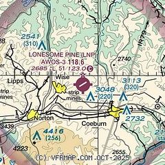
| Sectional chart |
|---|
|
| Airport distance calculator |
|---|
|
|
| Sunrise and sunset |
|---|
|
Times for 08-Jul-2026
| | Local
(UTC-4) | | Zulu
(UTC) |
|---|
| Morning civil twilight | | 05:48 | | 09:48 |
| Sunrise | | 06:19 | | 10:19 |
| Sunset | | 20:51 | | 00:51 |
| Evening civil twilight | | 21:22 | | 01:22 |
|
| Current date and time |
|---|
| Zulu (UTC) | 08-Jul-2026 16:57:40 |
|---|
| Local (UTC-4) | 08-Jul-2026 12:57:40 |
|---|
|
| METAR |
|---|
| KLNP | 081635Z AUTO 33005KT 10SM SCT028 SCT034 BKN040 25/20 A3017 RMK AO2
|
|
| TAF |
|---|
KTRI
31nm S | 081408Z 0814/0912 VRB03KT P6SM SCT010 BKN040 TEMPO 0814/0816 BKN015 FM081600 25007KT P6SM SCT040 PROB30 0822/0903 4SM TSRA BKN030CB
|
|
| NOTAMs |
|---|
NOTAMs are issued by the DoD/FAA and will open in a separate window not controlled by AirNav.
|
|


