FAA INFORMATION EFFECTIVE 09 JULY 2026
Location
| FAA Identifier: | RVN |
| Lat/Long: | 36-27-27.2850N 082-53-06.1230W
36-27.454750N 082-53.102050W
36.4575792,-82.8850342
(estimated) |
| Elevation: | 1254.6 ft. / 382.4 m (surveyed) |
| Variation: | 07W (2020) |
| From city: | 6 miles NE of ROGERSVILLE, TN |
| Time zone: | UTC -4 (UTC -5 during Standard Time) |
| Zip code: | 37857 |
Airport Operations
| Airport use: | Open to the public |
| Activation date: | 07/1965 |
| Control tower: | no |
| ARTCC: | ATLANTA CENTER |
| FSS: | NASHVILLE FLIGHT SERVICE STATION |
| NOTAMs facility: | BNA (NOTAM-D service available) |
| Attendance: | 0800-1700
UNATNDD MAJOR HOL. |
| Wind indicator: | lighted |
| Segmented circle: | yes |
| Lights: | ACTVT RWY 7 & 25 REILS; PAPIS 7 & 25; MIRLS RWY 7/25 - CTAF. |
| Beacon: | white-green (lighted land airport)
Operates sunset to sunrise. |
Airport Communications
| CTAF/UNICOM: | 122.8 |
| TRI CITY APPROACH: | 128.05 |
| TRI CITY DEPARTURE: | 128.05 |
| WX AWOS-3 at GCY (16 nm S): | 128.425 (423-639-5081) |
| WX AWOS-3 at 0VG (20 nm NW): | 120.125 (276-346-3333) |
- APCH/DEP SVC PRVDD BY ATLANTA ARTCC ON FREQS 127.85/269.3 (GLADE SPRINGS RCAG) WHEN TRI CITY APCH CTL CLSD.
Nearby radio navigation aids
| VOR radial/distance | | VOR name | | Freq | | Var |
|---|
| HMVr276/36.5 | | HOLSTON MOUNTAIN VORTAC | | 114.60 | | 04W |
Airport Services
| Fuel available: | 100LL
100LL:H24 SELF SVC FUEL AVBL. |
| Parking: | hangars and tiedowns |
| Airframe service: | MAJOR |
| Powerplant service: | MAJOR |
Runway Information
Runway 7/25
| Dimensions: | 3504 x 75 ft. / 1068 x 23 m |
| Surface: | asphalt, in fair condition |
| Weight bearing capacity: | |
| Runway edge lights: | medium intensity |
| RUNWAY 7 | | RUNWAY 25 |
| Latitude: | 36-27.328470N | | 36-27.581003N |
| Longitude: | 082-53.423405W | | 082-52.780672W |
| Elevation: | 1254.5 ft. | | 1229.8 ft. |
| Traffic pattern: | left | | left |
| Runway heading: | 071 magnetic, 064 true | | 251 magnetic, 244 true |
| Markings: | nonprecision, in fair condition | | nonprecision, in fair condition |
| Visual slope indicator: | 2-light PAPI on left (4.00 degrees glide path)
PAPI UNUSBL BYD 7 DEGS LEFT OF CNTRLN. | | 2-light PAPI on left (3.00 degrees glide path) |
| Runway end identifier lights: | yes | | yes |
| Touchdown point: | yes, no lights | | yes, no lights |
| Obstructions: | 24 ft. trees, 637 ft. from runway, 144 ft. right of centerline, 18:1 slope to clear | | 72 ft. trees, 1025 ft. from runway, 225 ft. right of centerline, 11:1 slope to clear |
Airport Ownership and Management from official FAA records
| Ownership: | Publicly-owned |
| Owner: | HAWKINS COUNTY
COURTHOUSE, 150 WASHINGTON ST
ROGERSVILLE, TN 37857
Phone 423-272-7359 |
| Manager: | MARK FINLEY
675 MAIN ST
SURGOINSVILLE, TN 37873
Phone 423-345-0219 |
Additional Remarks
| A30A-07 | 3118 FT MT RIDGE SE OF ARPT WI 9 NM. |
| - | DEER ON & INVOF ARPT. |
| - | FOR CD CTC ATLANTA ARTCC AT 770-210-7692. |
Instrument Procedures
NOTE: All procedures below are presented as PDF files. If you need a reader for these files, you should download the free Adobe Reader.NOT FOR NAVIGATION. Please procure official charts for flight.
FAA instrument procedures published for use from 09 July 2026 at 0901Z to 06 August 2026 at 0900Z.
IAPs - Instrument Approach Procedures |
|---|
| RNAV (GPS) RWY 07 | |
download (215KB) |
| RNAV (GPS) RWY 25 | |
download (219KB) |
| NOTE: Special Take-Off Minimums/Departure Procedures apply | |
download (255KB) |
Other nearby airports with instrument procedures:
KGCY - Greeneville Municipal Airport (16 nm S)
0VG - Lee County Airport (20 nm NW)
KTRI - Tri-Cities Airport (23 nm E)
KMOR - Moore-Murrell Airport (29 nm SW)
3A2 - The New Tazewell/Wayne Coffey Municipal Airport (33 nm W)
|
|

Road maps at:
MapQuest
Bing
Google
| Aerial photo |
|---|
WARNING: Photo may not be current or correct

Do you have a better or more recent aerial photo of Hawkins County Airport that you would like to share? If so, please send us your photo.
|
| Sectional chart |
|---|
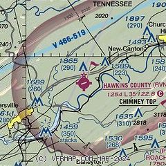
|
| Airport distance calculator |
|---|
|
|
| Sunrise and sunset |
|---|
|
Times for 01-Aug-2026
| | Local
(UTC-4) | | Zulu
(UTC) |
|---|
| Morning civil twilight | | 06:10 | | 10:10 |
| Sunrise | | 06:39 | | 10:39 |
| Sunset | | 20:37 | | 00:37 |
| Evening civil twilight | | 21:05 | | 01:05 |
|
| Current date and time |
|---|
| Zulu (UTC) | 01-Aug-2026 04:44:32 |
|---|
| Local (UTC-4) | 01-Aug-2026 00:44:32 |
|---|
|
| METAR |
|---|
K0VG
20nm NW | 010435Z AUTO 10SM CLR 19/19 A2997 RMK AO2
|
KTRI
23nm E | 010353Z 04003KT 10SM FEW060 OVC220 20/18 A2999 RMK AO2 SLP130 T02000183
|
KMOR
29nm SW | 010435Z AUTO 00000KT 9SM BKN050 BKN055 23/22 A2995 RMK A01
|
|
| TAF |
|---|
KTRI
23nm E | 311741Z 3118/0118 24005KT P6SM SCT050 FM010000 00000KT P6SM BKN200 FM011600 18004KT P6SM VCSH BKN050 OVC150
|
|
| NOTAMs |
|---|
NOTAMs are issued by the DoD/FAA and will open in a separate window not controlled by AirNav.
|
|

