FAA INFORMATION EFFECTIVE 09 JULY 2026
Location
| FAA Identifier: | 0VG |
| Lat/Long: | 36-39-14.7060N 083-13-04.2480W
36-39.245100N 083-13.070800W
36.6540850,-83.2178467
(estimated) |
| Elevation: | 1410.9 ft. / 430.0 m (surveyed) |
| Variation: | 06W (2005) |
| From city: | 5 miles SW of JONESVILLE, VA |
| Time zone: | UTC -4 (UTC -5 during Standard Time) |
| Zip code: | 24263 |
Airport Operations
| Airport use: | Open to the public |
| Activation date: | 09/2002 |
| Control tower: | no |
| ARTCC: | ATLANTA CENTER |
| FSS: | LEESBURG FLIGHT SERVICE STATION |
| NOTAMs facility: | DCA (NOTAM-D service available) |
| Attendance: | UNATNDD |
| Wind indicator: | lighted |
| Segmented circle: | yes |
| Lights: | ACTVT REIL RWY 07 & 25; PAPI RWY 07 & 25; MIRL RWY 07/25 - CTAF. |
| Beacon: | white-green (lighted land airport)
Operates sunset to sunrise. |
Airport Communications
| CTAF: | 122.9 |
| WX AWOS-3: | 120.125 (276-346-3333) |
| WX AWOS-3 at I35 (14 nm NW): | 118.35 (606-573-9104) |
- APCH/DEP SVC PRVDD BY ATLANTA ARTCC ON FREQS 127.55/269.50 (NEWPORT RCAG).
Airport Services
| Fuel available: | 100LL JET-A+ |
| Parking: | tiedowns |
Runway Information
Runway 7/25
| Dimensions: | 5003 x 75 ft. / 1525 x 23 m |
| Surface: | asphalt, in good condition |
| Weight bearing capacity: | |
| Runway edge lights: | medium intensity |
| RUNWAY 7 | | RUNWAY 25 |
| Latitude: | 36-39.039528N | | 36-39.450645N |
| Longitude: | 083-13.514173W | | 083-12.627383W |
| Elevation: | 1365.8 ft. | | 1410.9 ft. |
| Traffic pattern: | left | | left |
| Runway heading: | 066 magnetic, 060 true | | 246 magnetic, 240 true |
| Markings: | nonprecision, in fair condition | | nonprecision, in fair condition |
| Visual slope indicator: | 4-light PAPI on left (3.00 degrees glide path) | | 4-light PAPI on right (3.25 degrees glide path) |
| Runway end identifier lights: | yes | | yes |
| Touchdown point: | yes, no lights | | yes, no lights |
| Obstructions: | 67 ft. tree, 2367 ft. from runway, 477 ft. left of centerline, 32:1 slope to clear
3 FT TREE 108 FT FRM THLD, 198 FT L OF CNTRLN ON APCH. | | 15 ft. tree, 495 ft. from runway, 201 ft. left of centerline, 19:1 slope to clear |
Airport Ownership and Management from official FAA records
| Ownership: | Publicly-owned |
| Owner: | LEE COUNTY, VIRGINIA
PO BOX 367
JONESVILLE, VA 24263
Phone 276-346-7714 |
| Manager: | CLINT CARTER
33640 MAIN ST
JONESVILLE, VA 24263
Phone 276-346-7714
COUNTY ADMINISTRATOR. |
Additional Remarks
| - | FOR CD CTC ATLANTA ARTCC AT 770-210-7692. |
Instrument Procedures
NOTE: All procedures below are presented as PDF files. If you need a reader for these files, you should download the free Adobe Reader.NOT FOR NAVIGATION. Please procure official charts for flight.
FAA instrument procedures published for use from 09 July 2026 at 0901Z to 06 August 2026 at 0900Z.
IAPs - Instrument Approach Procedures |
|---|
| RNAV (GPS) RWY 07 | |
download (216KB) |
| RNAV (GPS) RWY 25 | |
download (214KB) |
| NOTE: Special Alternate Minimums apply | |
download (35KB) |
| NOTE: Special Take-Off Minimums/Departure Procedures apply | |
download (140KB) |
Other nearby airports with instrument procedures:
I35 - Tucker-Guthrie Memorial Airport (14 nm NW)
KRVN - Hawkins County Airport (20 nm SE)
3A2 - The New Tazewell/Wayne Coffey Municipal Airport (22 nm SW)
1A6 - Middlesboro/Bell County Airport (25 nm W)
KMOR - Moore-Murrell Airport (29 nm S)
|
|

Road maps at:
MapQuest
Bing
Google
| Aerial photo |
|---|
WARNING: Photo may not be current or correct
 Photo by Mark Dotson of Jonesville, Va
Photo taken 24-Nov-2007
Photo by Mark Dotson of Jonesville, Va
Photo taken 24-Nov-2007
Do you have a better or more recent aerial photo of Lee County Airport that you would like to share? If so, please send us your photo.
|
| Sectional chart |
|---|
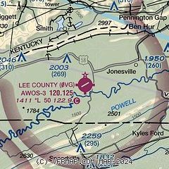
|
| Airport distance calculator |
|---|
|
|
| Sunrise and sunset |
|---|
|
Times for 24-Jul-2026
| | Local
(UTC-4) | | Zulu
(UTC) |
|---|
| Morning civil twilight | | 06:04 | | 10:04 |
| Sunrise | | 06:33 | | 10:33 |
| Sunset | | 20:45 | | 00:45 |
| Evening civil twilight | | 21:14 | | 01:14 |
|
| Current date and time |
|---|
| Zulu (UTC) | 24-Jul-2026 06:41:33 |
|---|
| Local (UTC-4) | 24-Jul-2026 02:41:33 |
|---|
|
| METAR |
|---|
| K0VG | 240615Z AUTO 10SM FEW025 OVC043 20/20 A3011 RMK AO2
|
KI35
14nm NW | 240615Z AUTO 00000KT 7SM SCT038 19/19 A3013 RMK AO2 T01850185
|
|
| NOTAMs |
|---|
NOTAMs are issued by the DoD/FAA and will open in a separate window not controlled by AirNav.
|
|

