FAA INFORMATION EFFECTIVE 30 OCTOBER 2025
Location
| FAA Identifier: | PPA |
| Lat/Long: | 35-36-46.8000N 100-59-46.5000W
35-36.780000N 100-59.775000W
35.6130000,-100.9962500
(estimated) |
| Elevation: | 3245.2 ft. / 989.1 m (surveyed) |
| Variation: | 06E (2015) |
| From city: | 5 miles NW of PAMPA, TX |
| Time zone: | UTC -6 (UTC -5 during Daylight Saving Time) |
| Zip code: | 79065 |
Airport Operations
| Airport use: | Open to the public |
| Activation date: | 05/1949 |
| Control tower: | no |
| ARTCC: | ALBUQUERQUE CENTER |
| FSS: | FORT WORTH FLIGHT SERVICE STATION |
| NOTAMs facility: | PPA (NOTAM-D service available) |
| Attendance: | 0800-1700 |
| Wind indicator: | lighted |
| Segmented circle: | yes |
| Lights: | DUSK-DAWN. MIRL RWYS 05/23 & 17/35 PRESET LOW INTST; TO INCR INTST ACTVT - CTAF. |
| Beacon: | white-green (lighted land airport)
Operates sunset to sunrise. |
Airport Communications
| CTAF/UNICOM: | 122.7 |
| WX AWOS-3: | 118.725 (806-669-1333) |
- APCH/DEP SVC PRVDD BY ALBUQUERQUE ARTCC (ZAB) ON FREQS 127.85/285.475 (AMARILLO RCAG).
Airport Services
| Fuel available: | 100LL JET-A1+
100LL:FOR FUEL AFT HRS CALL 806-395-1117. |
| Parking: | hangars and tiedowns |
| Airframe service: | MAJOR |
| Powerplant service: | MAJOR |
| Bottled oxygen: | NONE |
| Bulk oxygen: | NONE |
Runway Information
Runway 17/35
| Dimensions: | 5862 x 100 ft. / 1787 x 30 m |
| Surface: | asphalt, in good condition |
| Weight bearing capacity: | |
| Runway edge lights: | medium intensity |
| RUNWAY 17 | | RUNWAY 35 |
| Latitude: | 35-37.109595N | | 35-36.143462N |
| Longitude: | 100-59.629520W | | 100-59.629992W |
| Elevation: | 3238.9 ft. | | 3240.7 ft. |
| Traffic pattern: | left | | left |
| Runway heading: | 174 magnetic, 180 true | | 354 magnetic, 000 true |
| Markings: | nonprecision, in good condition | | nonprecision, in good condition |
| Visual slope indicator: | 2-light PAPI on left (3.00 degrees glide path) | | 2-light PAPI on left (3.00 degrees glide path) |
| Runway end identifier lights: | no | | no |
| Touchdown point: | yes, no lights | | yes, no lights |
| Obstructions: | 15 ft. road, 730 ft. from runway, 35:1 slope to clear
TAIL HGT OF AIRPLANE ON RWY 05/23, 173 FT FM CNTRLN TO THR. | | none |
Runway 5/23
| Dimensions: | 4500 x 75 ft. / 1372 x 23 m |
| Surface: | asphalt, in good condition |
| Weight bearing capacity: | |
| Runway edge lights: | medium intensity |
| RUNWAY 5 | | RUNWAY 23 |
| Latitude: | 35-36.794478N | | 35-37.164823N |
| Longitude: | 101-00.359420W | | 100-59.572567W |
| Elevation: | 3242.5 ft. | | 3238.1 ft. |
| Traffic pattern: | left | | left |
| Runway heading: | 054 magnetic, 060 true | | 234 magnetic, 240 true |
| Markings: | basic, in good condition | | basic, in good condition |
| Touchdown point: | yes, no lights | | yes, no lights |
| Obstructions: | none | | 25 ft. pline, marked, 900 ft. from runway, 25 ft. right of centerline, 28:1 slope to clear |
Airport Ownership and Management from official FAA records
| Ownership: | Publicly-owned |
| Owner: | GRAY COUNTY
GRAY CO COURTHOUSE
PAMPA, TX 79065
Phone 806-669-8004
CO. CLERK. |
| Manager: | CHRIS PORTER
205 N. RUSSELL
PAMPA, TX 79065
Phone 806-669-8007
RON UNRUH 806-665-1881. AFTR HRS DARRELL DOWNS 806-395-1117. |
Additional Remarks
| - | ANTELOPE ON & INVOF RWY. |
| - | NO LINE OF SIGHT BTN BOTH RWY ENDS. |
| - | FOR CD CTC ALBUQUERQUE ARTCC AT 505-856-4861. |
Instrument Procedures
NOTE: All procedures below are presented as PDF files. If you need a reader for these files, you should download the free Adobe Reader.NOT FOR NAVIGATION. Please procure official charts for flight.
FAA instrument procedures published for use from 30 October 2025 at 0901Z to 27 November 2025 at 0900Z.
IAPs - Instrument Approach Procedures |
|---|
| RNAV (GPS) RWY 17 | |
download (210KB) |
| NOTE: Special Alternate Minimums apply | |
download (137KB) |
| NOTE: Special Take-Off Minimums/Departure Procedures apply | |
download (300KB) |
Other nearby airports with instrument procedures:
KBGD - Hutchinson County Airport (20 nm W)
T45 - Panhandle-Carson County Airport (23 nm SW)
KHHF - Hemphill County Airport (33 nm NE)
E42 - Major Samuel B Cornelius Field Airport (38 nm N)
T59 - Wheeler Municipal Airport (40 nm E)
|
|

Road maps at:
MapQuest
Bing
Google
| Aerial photo |
|---|
WARNING: Photo may not be current or correct

Do you have a better or more recent aerial photo of Perry Lefors Field Airport that you would like to share? If so, please send us your photo.
|
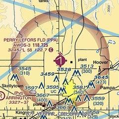
| Sectional chart |
|---|
|
| Airport distance calculator |
|---|
|
|
| Sunrise and sunset |
|---|
|
Times for 05-Nov-2025
| | Local
(UTC-6) | | Zulu
(UTC) |
|---|
| Morning civil twilight | | 06:44 | | 12:44 |
| Sunrise | | 07:11 | | 13:11 |
| Sunset | | 17:44 | | 23:44 |
| Evening civil twilight | | 18:11 | | 00:11 |
|
| Current date and time |
|---|
| Zulu (UTC) | 05-Nov-2025 18:35:37 |
|---|
| Local (UTC-6) | 05-Nov-2025 12:35:37 |
|---|
|
| METAR |
|---|
KPPA
6nm S | 051815Z AUTO 03015G22KT 10SM CLR 18/02 A3028 RMK AO2 T01830017
|
KBPC
17nm N | 051815Z AUTO 05011G19KT 10SM CLR 18/M01 A3028 RMK AO2
|
|
| TAF |
|---|
KAMA
42nm SW | 051720Z 0518/0618 01018G28KT P6SM SKC FM052200 04013G23KT P6SM SKC FM060000 06008KT P6SM FEW250 FM060900 19005KT P6SM SKC FM061400 22012KT P6SM SKC FM061600 22018G28KT P6SM SKC
|
|
| NOTAMs |
|---|
NOTAMs are issued by the DoD/FAA and will open in a separate window not controlled by AirNav.
|
|


