FAA INFORMATION EFFECTIVE 14 MAY 2026
Location
| FAA Identifier: | HHF |
| Lat/Long: | 35-53-42.4000N 100-24-14.0000W
35-53.706667N 100-24.233333W
35.8951111,-100.4038889
(estimated) |
| Elevation: | 2396.4 ft. / 730.4 m (surveyed) |
| Variation: | 06E (2015) |
| From city: | 2 miles SW of CANADIAN, TX |
| Time zone: | UTC -5 (UTC -6 during Standard Time) |
| Zip code: | 79014 |
Airport Operations
| Airport use: | Open to the public |
| Activation date: | 07/1945 |
| Control tower: | no |
| ARTCC: | ALBUQUERQUE CENTER |
| FSS: | FORT WORTH FLIGHT SERVICE STATION |
| NOTAMs facility: | HHF (NOTAM-D service available) |
| Attendance: | MON-FRI 0800-1700 |
| Wind indicator: | lighted |
| Segmented circle: | yes |
| Lights: | DUSK-DAWN. MIRL RWY 04/22 AND RWY 18/36 PRESET LOW INTST; TO INCR INTST ACTVT - CTAF. |
| Beacon: | white-green (lighted land airport)
Operates sunset to sunrise. |
Airport Communications
| CTAF: | 122.9 |
| WX AWOS-3PT: | 119.025 (806-225-8080) |
- APCH/DEP CTL SVC PRVDD BY ALBUQUERQUE ARTCC ON (ZAB) FREQS 127.85/285.475 (AMARILLO RCAG).
- AIRCRAFT EXECUTING MISSED APCH ON RNAV (GPS) RY 04 CTC KANSAS CITY ARTCC (ZKC) ON 126.95/379.2 (GAGE RCAG).
Nearby radio navigation aids
| VOR radial/distance | | VOR name | | Freq | | Var |
|---|
| MMBr213/37.0 | | MITBEE VORTAC | | 115.60 | | 10E |
Airport Services
| Fuel available: | 100LL JET-A JET-A++10 |
| Parking: | hangars and tiedowns |
| Bottled oxygen: | NONE |
| Bulk oxygen: | NONE |
Runway Information
Runway 4/22
| Dimensions: | 5004 x 75 ft. / 1525 x 23 m |
| Surface: | asphalt, in excellent condition |
| Weight bearing capacity: | |
| Runway edge lights: | medium intensity |
| RUNWAY 4 | | RUNWAY 22 |
| Latitude: | 35-53.408833N | | 35-53.998000N |
| Longitude: | 100-24.618833W | | 100-23.909500W |
| Elevation: | 2387.4 ft. | | 2375.6 ft. |
| Traffic pattern: | left | | right |
| Runway heading: | 038 magnetic, 044 true | | 218 magnetic, 224 true |
| Markings: | nonprecision, in good condition | | nonprecision, in good condition |
| Visual slope indicator: | 2-light PAPI on left (3.00 degrees glide path) | | 2-light PAPI on left (3.00 degrees glide path) |
| Runway end identifier lights: | yes | | yes |
| Touchdown point: | yes, no lights | | yes, no lights |
| Obstructions: | 8 ft. fence, 390 ft. from runway, 23:1 slope to clear | | 46 ft. trees, 1417 ft. from runway, 26:1 slope to clear |
Runway 18/36
| Dimensions: | 3001 x 60 ft. / 915 x 18 m |
| Surface: | asphalt, in excellent condition |
| Weight bearing capacity: | |
| Runway edge lights: | medium intensity |
| RUNWAY 18 | | RUNWAY 36 |
| Latitude: | 35-53.960158N | | 35-53.467780N |
| Longitude: | 100-24.152435W | | 100-24.208297W |
| Elevation: | 2367.6 ft. | | 2396.4 ft. |
| Traffic pattern: | right | | left |
| Runway heading: | 179 magnetic, 185 true | | 359 magnetic, 005 true |
| Displaced threshold: | 100 ft. | | no |
| Markings: | basic, in good condition | | basic, in good condition |
| Touchdown point: | yes, no lights | | yes, no lights |
| Obstructions: | 10 ft. road, 210 ft. from runway, 126 ft. right of centerline, 1:1 slope to clear | | 6 ft. fence, 212 ft. from runway, 2:1 slope to clear |
Airport Ownership and Management from official FAA records
| Ownership: | Publicly-owned |
| Owner: | HEMPHILL COUNTY
400 MAIN STREET, SUITE 200
CANADIAN, TX 79014
Phone 806-323-6521 |
| Manager: | BILL KENDALL
255 AIRPORT ROAD - PO BOX 96
CANADIAN, TX 79014
Phone 806-679-4774 |
Additional Remarks
| - | 15 FT DITCH N OF RWY 04 THR EXTDG 1000 FT ALG LEFT SIDE OF RWY. |
| - | FOR CD CTC ALBUQUERQUE ARTCC AT 505-856-4861. |
Instrument Procedures
NOTE: All procedures below are presented as PDF files. If you need a reader for these files, you should download the free Adobe Reader.NOT FOR NAVIGATION. Please procure official charts for flight.
FAA instrument procedures published for use from 14 May 2026 at 0901Z to 11 June 2026 at 0900Z.
IAPs - Instrument Approach Procedures |
|---|
| RNAV (GPS) RWY 04 | |
download (266KB) |
| RNAV (GPS) RWY 22 | |
download (254KB) |
| NOTE: Special Alternate Minimums apply | |
download |
| NOTE: Special Take-Off Minimums/Departure Procedures apply | |
download (304KB) |
Other nearby airports with instrument procedures:
1X1 - Higgins/Lipscomb County Airport (22 nm NE)
T59 - Wheeler Municipal Airport (28 nm S)
KPPA - Perry Lefors Field Airport (33 nm SW)
KPYX - Perryton Ochiltree County Airport (35 nm NW)
E42 - Major Samuel B Cornelius Field Airport (43 nm NW)
|
|

Road maps at:
MapQuest
Bing
Google
| Aerial photo |
|---|
WARNING: Photo may not be current or correct
 Photo by Roger Hansen
Photo taken 04-Aug-2008
Photo by Roger Hansen
Photo taken 04-Aug-2008
Do you have a better or more recent aerial photo of Hemphill County Airport that you would like to share? If so, please send us your photo.
|
| Sectional chart |
|---|
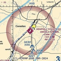
|
| Airport distance calculator |
|---|
|
|
| Sunrise and sunset |
|---|
|
Times for 10-Jun-2026
| | Local
(UTC-5) | | Zulu
(UTC) |
|---|
| Morning civil twilight | | 05:56 | | 10:56 |
| Sunrise | | 06:26 | | 11:26 |
| Sunset | | 20:56 | | 01:56 |
| Evening civil twilight | | 21:26 | | 02:26 |
|
| Current date and time |
|---|
| Zulu (UTC) | 10-Jun-2026 16:42:03 |
|---|
| Local (UTC-5) | 10-Jun-2026 11:42:03 |
|---|
|
| METAR |
|---|
| KHHF | 101615Z AUTO 22020G26KT 10SM CLR 32/19 A2978 RMK AO2 PK WND 22028/35
|
|
| NOTAMs |
|---|
NOTAMs are issued by the DoD/FAA and will open in a separate window not controlled by AirNav.
|
|

