FAA INFORMATION EFFECTIVE 22 JANUARY 2026
Location
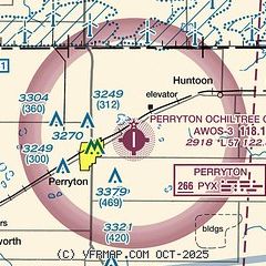
| FAA Identifier: | PYX |
| Lat/Long: | 36-24-46.5040N 100-45-05.6750W
36-24.775067N 100-45.094583W
36.4129178,-100.7515764
(estimated) |
| Elevation: | 2918.4 ft. / 889.5 m (surveyed) |
| Variation: | 07E (2010) |
| From city: | 3 miles E of PERRYTON, TX |
| Time zone: | UTC -6 (UTC -5 during Daylight Saving Time) |
| Zip code: | 79070 |
Airport Operations
| Airport use: | Open to the public |
| Activation date: | 05/1942 |
| Control tower: | no |
| ARTCC: | KANSAS CITY CENTER |
| FSS: | FORT WORTH FLIGHT SERVICE STATION |
| NOTAMs facility: | PYX (NOTAM-D service available) |
| Attendance: | MON-SAT 0800-1700, ALL SUN 1300-1700 |
| Wind indicator: | lighted |
| Segmented circle: | yes |
| Lights: | DUSK-DAWN. MIRL RWY 17/35 PRESET LOW INTST; TO INCR INTST - CTAF. PAPI RWY 17 & 35 OPR CONSLY. |
| Beacon: | white-green (lighted land airport)
Operates sunset to sunrise. |
Airport Communications
| CTAF/UNICOM: | 122.8 |
| WX AWOS-3: | 118.175 (806-435-9963) |
- APCH/DEP CTL SVC PRVDD BY KANSAS CITY ARTCC (ZKC) ON FREQS 126.95/379.2 (GAGE RCAG).
Nearby radio navigation aids
| NDB name | | Hdg/Dist | | Freq | | Var | | ID |
|---|
| PERRYTON | | at field | | 266 | | 07E | | PYX | .--. -.-- -..- |
Airport Services
| Fuel available: | 100LL JET-A1+
100LL:FOR FUEL AFT HRS CALL 806-435-4226 OR 806-228-5573. |
| Parking: | hangars and tiedowns |
| Airframe service: | MAJOR |
| Powerplant service: | MAJOR |
| Bottled oxygen: | NONE |
| Bulk oxygen: | NONE |
Runway Information
Runway 17/35
| Dimensions: | 5701 x 75 ft. / 1738 x 23 m |
| Surface: | asphalt, in excellent condition |
| Weight bearing capacity: | |
| Runway edge lights: | medium intensity |
| RUNWAY 17 | | RUNWAY 35 |
| Latitude: | 36-25.364597N | | 36-24.425107N |
| Longitude: | 100-44.984077W | | 100-44.981417W |
| Elevation: | 2914.7 ft. | | 2914.5 ft. |
| Traffic pattern: | left | | left |
| Runway heading: | 173 magnetic, 180 true | | 353 magnetic, 360 true |
| Markings: | nonprecision, in good condition | | nonprecision, in good condition |
| Visual slope indicator: | 4-light PAPI on left (3.00 degrees glide path) | | 4-light PAPI on left (3.00 degrees glide path) |
| Touchdown point: | yes, no lights | | yes, no lights |
| Obstructions: | 23 ft. pole, 856 ft. from runway, 363 ft. right of centerline, 28:1 slope to clear
9 FT SUPPLL WINDSOCK 12 FT FM THR, 187 FT RIGHT. | | 15 ft. road, 500 ft. from runway, 20:1 slope to clear
9 FT SUPPLL WINDSOCK, 44 FT DSTC, 197 FT RIGHT. |
Runway 4/22
| Dimensions: | 3280 x 144 ft. / 1000 x 44 m
SOUTH 1000 FT CLSD INDEFLY. 2280 FT AVBL. |
| Surface: | turf, in poor condition
RWY ENDS INDEF, MKD BY MOWING. SFC ROUGH WITH LARGE ANIMAL HOLES. |
| RUNWAY 4 | | RUNWAY 22 |
| Latitude: | 36-24.397050N | | 36-24.736683N |
| Longitude: | 100-45.549100W | | 100-45.028833W |
| Elevation: | 2915.0 ft. | | 2915.0 ft. |
| Traffic pattern: | left | | left |
| Runway heading: | 044 magnetic, 051 true | | 224 magnetic, 231 true |
| Touchdown point: | yes, no lights | | yes, no lights |
| Obstructions: | 15 ft. road, 120 ft. right of centerline
15 FT. GRAVEL RD AT RWY END. | | 30 ft. pline, 1200 ft. from runway, 120 ft. left of centerline, 40:1 slope to clear |
Airport Ownership and Management from official FAA records
| Ownership: | Publicly-owned |
| Owner: | PERRYTON & OCHILTREE COUNTY
511 S MAIN
PERRYTON, TX 79070
Phone 806-435-8031 |
| Manager: | BEAR KNOX
PO BOX 709
PERRYTON, TX 79070
Phone 806-435-4226 |
Additional Remarks
| - | FOR CD CTC KANSAS CITY ARTCC AT 913-254-8508. |
Instrument Procedures
NOTE: All procedures below are presented as PDF files. If you need a reader for these files, you should download the free Adobe Reader.NOT FOR NAVIGATION. Please procure official charts for flight.
FAA instrument procedures published for use from 22 January 2026 at 0901Z to 19 February 2026 at 0900z.
IAPs - Instrument Approach Procedures |
|---|
| RNAV (GPS) RWY 17 | |
download (197KB) |
| RNAV (GPS) RWY 35 | |
download (252KB) |
| NDB-A | |
download (159KB) |
| NOTE: Special Alternate Minimums apply | |
download (28KB) |
| NOTE: Special Take-Off Minimums/Departure Procedures apply | |
download (167KB) |
Other nearby airports with instrument procedures:
E42 - Major Samuel B Cornelius Field Airport (24 nm SW)
E19 - Gruver Municipal Airport (35 nm W)
KHHF - Hemphill County Airport (35 nm SE)
KLBL - Liberal Mid-America Regional Airport (39 nm N)
1X1 - Higgins/Lipscomb County Airport (40 nm SE)
|
|

Road maps at:
MapQuest
Bing
Google
| Aerial photo |
|---|
WARNING: Photo may not be current or correct

Do you have a better or more recent aerial photo of Perryton Ochiltree County Airport that you would like to share? If so, please send us your photo.
|
| Sectional chart |
|---|
|
| Airport distance calculator |
|---|
|
|
| Sunrise and sunset |
|---|
|
Times for 12-Feb-2026
| | Local
(UTC-6) | | Zulu
(UTC) |
|---|
| Morning civil twilight | | 07:09 | | 13:09 |
| Sunrise | | 07:35 | | 13:35 |
| Sunset | | 18:20 | | 00:20 |
| Evening civil twilight | | 18:46 | | 00:46 |
|
| Current date and time |
|---|
| Zulu (UTC) | 12-Feb-2026 16:31:57 |
|---|
| Local (UTC-6) | 12-Feb-2026 10:31:57 |
|---|
|
| METAR |
|---|
KPYX
3nm N | 121615Z AUTO 31008KT 10SM CLR 11/M02 A3009 RMK AO2 T01051021
|
|
| TAF |
|---|
KLBL
39nm N | 121137Z 1212/1312 VRB06KT P6SM BKN250
|
KGUY
40nm NW | 121120Z 1212/1312 29006KT P6SM BKN200 FM122200 04007KT P6SM FEW250
|
|
| NOTAMs |
|---|
NOTAMs are issued by the DoD/FAA and will open in a separate window not controlled by AirNav.
|
|


