FAA INFORMATION EFFECTIVE 19 FEBRUARY 2026
Location
| FAA Identifier: | 1X1 |
| Lat/Long: | 36-06-21.2500N 100-01-32.5440W
36-06.354167N 100-01.542400W
36.1059028,-100.0257067
(estimated) |
| Elevation: | 2565.5 ft. / 782.0 m (surveyed) |
| Variation: | 08E (1995) |
| From city: | 1 mile S of HIGGINS, TX |
| Time zone: | UTC -6 (UTC -5 during Daylight Saving Time) |
| Zip code: | 79046 |
Airport Operations
| Airport use: | Open to the public |
| Activation date: | 02/1965 |
| Control tower: | no |
| ARTCC: | KANSAS CITY CENTER |
| FSS: | FORT WORTH FLIGHT SERVICE STATION |
| NOTAMs facility: | FTW (NOTAM-D service available) |
| Attendance: | UNATNDD |
| Wind indicator: | yes |
| Segmented circle: | no |
Airport Communications
| CTAF: | 122.9 |
| WX ASOS at GAG (17 nm NE): | 128.625 (580-923-7581) |
- APCH/DEP CTL SVC PRVDD BY KANSAS CITY ARTCC (ZKC) ON FREQS 126.95/379.2 (GAGE RCAG).
Nearby radio navigation aids
| VOR radial/distance | | VOR name | | Freq | | Var |
|---|
| MMBr196/15.9 | | MITBEE VORTAC | | 115.60 | | 10E |
| NDB name | | Hdg/Dist | | Freq | | Var | | ID |
|---|
| PERRYTON | | 111/39.5 | | 266 | | 07E | | PYX | .--. -.-- -..- |
Airport Services
| Parking: | tiedowns |
| Airframe service: | NONE |
| Powerplant service: | NONE |
| Bottled oxygen: | NONE |
| Bulk oxygen: | NONE |
Runway Information
Runway 18/36
| Dimensions: | 3969 x 60 ft. / 1210 x 18 m |
| Surface: | asphalt, in fair condition
PEA STONE SURFACE SEAL, LOOSE STONES ON RWY. |
| Weight bearing capacity: | |
| RUNWAY 18 | | RUNWAY 36 |
| Latitude: | 36-06.675367N | | 36-06.033983N |
| Longitude: | 100-01.462650W | | 100-01.620983W |
| Elevation: | 2565.5 ft. | | 2537.2 ft. |
| Traffic pattern: | left | | left |
| Runway heading: | 183 magnetic, 191 true | | 003 magnetic, 011 true |
| Displaced threshold: | 196 ft. | | no |
| Markings: | basic, in fair condition | | basic, in fair condition |
| Touchdown point: | yes, no lights | | yes, no lights |
| Obstructions: | 28 ft. trees, 395 ft. from runway, 30 ft. right of centerline, 6:1 slope to clear
APCH SLOPE 21:1 AT DSPLCD THR OVR 28 FT TREES, 591 FT DSTC, 30 FT R. | | none |
Airport Ownership and Management from official FAA records
| Ownership: | Publicly-owned |
| Owner: | LIPSCOMB CO.
COUNTY COURTHOUSE, 101 S MAIN
LIPSCOMB, TX 79056
Phone 806-862-4131 |
| Manager: | DAN COCKRELL
COUNTY COURTHOUSE, 101 S. MAIN
LIPSCOMB, TX 79056
Phone 806-862-4131
806-480-4426. |
Additional Remarks
| - | NO LINE OF SIGHT BTN RWY ENDS. |
| - | FOR CD CTC KANSAS CITY ARTCC AT 913-254-8508. |
| - | 120 FT AGL WATER TWR, 2000 FT NW OF RWY 18 END, UNLGTD. |
Instrument Procedures
NOTE: All procedures below are presented as PDF files. If you need a reader for these files, you should download the free Adobe Reader.NOT FOR NAVIGATION. Please procure official charts for flight.
FAA instrument procedures published for use from 19 February 2026 at 0901Z to 19 March 2026 at 0900Z.
IAPs - Instrument Approach Procedures |
|---|
| VOR/DME-A | |
download (151KB) |
| NOTE: Special Take-Off Minimums/Departure Procedures apply | |
download (297KB) |
Other nearby airports with instrument procedures:
KHHF - Hemphill County Airport (22 nm SW)
KWWR - West Woodward Airport (31 nm NE)
KPYX - Perryton Ochiltree County Airport (40 nm NW)
T59 - Wheeler Municipal Airport (40 nm S)
KMDF - Mooreland Municipal Airport (46 nm NE)
|
|

Road maps at:
MapQuest
Bing
Google
| Aerial photo |
|---|

|
| Sectional chart |
|---|
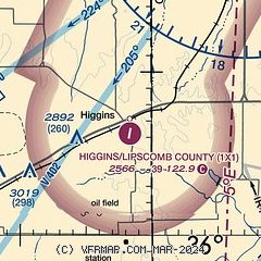
|
| Airport distance calculator |
|---|
|
|
| Sunrise and sunset |
|---|
|
Times for 06-Mar-2026
| | Local
(UTC-6) | | Zulu
(UTC) |
|---|
| Morning civil twilight | | 06:39 | | 12:39 |
| Sunrise | | 07:05 | | 13:05 |
| Sunset | | 18:38 | | 00:38 |
| Evening civil twilight | | 19:04 | | 01:04 |
|
| Current date and time |
|---|
| Zulu (UTC) | 06-Mar-2026 23:04:01 |
|---|
| Local (UTC-6) | 06-Mar-2026 17:04:01 |
|---|
|
| METAR |
|---|
KHHF
22nm SW | 062255Z AUTO 25018G23KT 10SM CLR 27/M07 A2966 RMK AO2 PK WND 23028/12
|
|
| NOTAMs |
|---|
NOTAMs are issued by the DoD/FAA and will open in a separate window not controlled by AirNav.
|
|


