FAA INFORMATION EFFECTIVE 25 DECEMBER 2025
Location
| FAA Identifier: | WWR |
| Lat/Long: | 36-26-16.8000N 099-31-21.6000W
36-26.280000N 099-31.360000W
36.4380000,-99.5226667
(estimated) |
| Elevation: | 2189 ft. / 667.2 m (surveyed) |
| Variation: | 08E (1985) |
| From city: | 6 miles W of WOODWARD, OK |
| Time zone: | UTC -6 (UTC -5 during Daylight Saving Time) |
| Zip code: | 73801 |
Airport Operations
| Airport use: | Open to the public |
| Activation date: | 03/1943 |
| Control tower: | no |
| ARTCC: | KANSAS CITY CENTER |
| FSS: | MC ALESTER FLIGHT SERVICE STATION |
| NOTAMs facility: | WWR (NOTAM-D service available) |
| Attendance: | MON-FRI 0800-1800, ALL SAT-SUN 0800-1600
UNATNDD SUN AND HOL. |
| Wind indicator: | lighted |
| Segmented circle: | yes |
| Lights: | ACTVT & INCR INTST ODALS RWY 17; REIL RWY 35; MIRL RWY 17/35, 05/23 - CTAF. PAPI RWY 17 & 35 24-HR PHOTO CELL. |
| Beacon: | white-green (lighted land airport)
Operates sunset to sunrise. |
Airport Communications
| CTAF/UNICOM: | 122.8 |
| WX AWOS-3: | 118.425 (580-254-5217) |
| WX ASOS at GAG (15 nm SW): | 128.625 (580-923-7581) |
- APCH/DEP CTL SVC PRVDD BY KANSAS CITY ARTCC (ZKC) ON FREQS 126.95/379.2 (GAGE RCAG).
Nearby radio navigation aids
| VOR radial/distance | | VOR name | | Freq | | Var |
|---|
| MMBr062/18.2 | | MITBEE VORTAC | | 115.60 | | 10E |
Airport Services
| Fuel available: | 100LL JET-A+ |
| Parking: | hangars and tiedowns |
| Airframe service: | MINOR |
| Powerplant service: | MINOR |
| Bottled oxygen: | NONE |
| Bulk oxygen: | NONE |
Runway Information
Runway 17/35
| Dimensions: | 5502 x 100 ft. / 1677 x 30 m |
| Surface: | concrete, in good condition |
| Weight bearing capacity: | | Single wheel: | 30.0 | | Double wheel: | 60.0 |
|
| Runway edge lights: | medium intensity |
| RUNWAY 17 | | RUNWAY 35 |
| Latitude: | 36-26.655403N | | 36-25.748732N |
| Longitude: | 099-31.255507W | | 099-31.264548W |
| Elevation: | 2161.1 ft. | | 2188.8 ft. |
| Traffic pattern: | left | | left |
| Runway heading: | 172 magnetic, 180 true | | 352 magnetic, 000 true |
| Markings: | nonprecision, in good condition | | nonprecision, in good condition |
| Visual slope indicator: | 4-light PAPI on left (3.00 degrees glide path) | | 4-light PAPI on left (3.00 degrees glide path) |
| Approach lights: | ODALS: omnidirectional approach lighting system | | |
| Runway end identifier lights: | no | | yes |
| Touchdown point: | yes, no lights | | yes, no lights |
Runway 5/23
| Dimensions: | 2500 x 60 ft. / 762 x 18 m |
| Surface: | asphalt, in fair condition |
| Runway edge lights: | medium intensity |
| Runway edge markings: | MKGS FADED & OBSCD. |
| RUNWAY 5 | | RUNWAY 23 |
| Latitude: | 36-26.349392N | | 36-26.552560N |
| Longitude: | 099-31.803943W | | 099-31.360348W |
| Elevation: | 2166.5 ft. | | 2164.1 ft. |
| Traffic pattern: | left | | right |
| Runway heading: | 052 magnetic, 060 true | | 232 magnetic, 240 true |
| Markings: | basic, in poor condition | | basic, in poor condition |
| Touchdown point: | yes, no lights | | yes, no lights |
Airport Ownership and Management from official FAA records
| Ownership: | Publicly-owned |
| Owner: | CITY OF WOODWARD
722 MAIN ST.
WOODWARD, OK 73801
Phone 580-256-2280 |
| Manager: | CHRIS AMES
1301 AIRPARK RD
WOODWARD, OK 73801
Phone 580-334-5786 |
Additional Remarks
| - | ULTRALIGHT ACTIVITY ON & INVOF ARPT. |
| - | TETRAHEDRON OTS. |
| - | DEER & COYOTES ON & INVOF ARPT. |
| - | FOR CD CTC KANSAS CITY ARTCC AT 913-254-8508. |
| - | AFT HRS CTC 580-216-8233/ CALL OUT FEE. |
| - | 24 HR. LOUNGE |
| - | SELF SVC FUEL AVBL 24/7. |
Instrument Procedures
NOTE: All procedures below are presented as PDF files. If you need a reader for these files, you should download the free Adobe Reader.NOT FOR NAVIGATION. Please procure official charts for flight.
FAA instrument procedures published for use from 25 December 2025 at 0901z to 22 January 2026 at 0900z.
IAPs - Instrument Approach Procedures |
|---|
| RNAV (GPS) RWY 17 | |
download (220KB) |
| RNAV (GPS) RWY 35 | |
download (222KB) |
| VOR/DME-A | |
download (192KB) |
| NOTE: Special Alternate Minimums apply | |
download (121KB) |
| NOTE: Special Take-Off Minimums/Departure Procedures apply | |
download (389KB) |
Other nearby airports with instrument procedures:
KMDF - Mooreland Municipal Airport (16 nm E)
KBFK - Buffalo Municipal Airport (26 nm N)
1X1 - Higgins/Lipscomb County Airport (31 nm SW)
KAVK - Alva Regional Airport (46 nm NE)
3K8 - Comanche County Airport (48 nm N)
|
|

Road maps at:
MapQuest
Bing
Google
| Aerial photo |
|---|
WARNING: Photo may not be current or correct

Do you have a better or more recent aerial photo of West Woodward Airport that you would like to share? If so, please send us your photo.
|
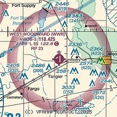
| Sectional chart |
|---|
|
| Airport distance calculator |
|---|
|
|
| Sunrise and sunset |
|---|
|
Times for 10-Jan-2026
| | Local
(UTC-6) | | Zulu
(UTC) |
|---|
| Morning civil twilight | | 07:23 | | 13:23 |
| Sunrise | | 07:51 | | 13:51 |
| Sunset | | 17:40 | | 23:40 |
| Evening civil twilight | | 18:09 | | 00:09 |
|
| Current date and time |
|---|
| Zulu (UTC) | 10-Jan-2026 21:20:29 |
|---|
| Local (UTC-6) | 10-Jan-2026 15:20:29 |
|---|
|
| METAR |
|---|
KWWR
10nm N | 102055Z AUTO 28015G20KT 10SM CLR 09/M10 A3045 RMK AO2 T00921103
|
KGAG
14nm SW | 102053Z AUTO 30016G25KT 10SM CLR 09/M12 A3043 RMK AO2 SLP314 T00941122 56021 $
|
|
| TAF |
|---|
KWWR
10nm N | 101720Z 1018/1118 29010KT P6SM SKC FM110000 27008KT P6SM SKC
|
|
| NOTAMs |
|---|
NOTAMs are issued by the DoD/FAA and will open in a separate window not controlled by AirNav.
|
|


