FAA INFORMATION EFFECTIVE 19 MARCH 2026
Location
| FAA Identifier: | RWF |
| Lat/Long: | 44-32-48.8000N 095-04-55.2000W
44-32.813333N 095-04.920000W
44.5468889,-95.0820000
(estimated) |
| Elevation: | 1023.6 ft. / 312.0 m (surveyed) |
| Variation: | 04E (2000) |
| From city: | 2 miles NE of REDWOOD FALLS, MN |
| Time zone: | UTC -5 (UTC -6 during Standard Time) |
| Zip code: | 56283 |
Airport Operations
| Airport use: | Open to the public |
| Activation date: | 06/1942 |
| Control tower: | no |
| ARTCC: | MINNEAPOLIS CENTER |
| FSS: | PRINCETON FLIGHT SERVICE STATION |
| NOTAMs facility: | RWF (NOTAM-D service available) |
| Attendance: | MON-FRI 0800-1700 |
| Wind indicator: | lighted |
| Segmented circle: | yes |
| Lights: | ACTVT OR INCR INTST REIL RWY 12 & 30; PAPI RWY 12 & 30; MIRL RWY 12/30 - CTAF. MIRL RWY 12/30 PRESET LOW INTST. |
| Beacon: | white-green (lighted land airport)
Operates sunset to sunrise. |
Airport Communications
| CTAF/UNICOM: | 123.0 |
| WX ASOS: | 126.575 (507-644-3564) |
| WX AWOS-3 at OVL (14 nm N): | 119.275 (320-523-5924) |
- APCH/DEP SVC PRVDD BY MINNEAPOLIS ARTCC ON FREQS 127.1/290.2 (REDWOOD FALLS RCAG).
Nearby radio navigation aids
| VOR radial/distance | | VOR name | | Freq | | Var |
|---|
| RWFr015/5.2 | | REDWOOD FALLS VOR/DME | | 113.30 | | 07E |
| MMLr074/32.3 | | MARSHALL VOR/DME | | 111.00 | | 05E |
| BDHr173/34.3 | | WILLMAR VOR/DME | | 113.70 | | 04E |
| MVEr129/37.1 | | MONTEVIDEO VOR/DME | | 111.60 | | 05E |
Airport Services
| Fuel available: | 100LL JET-A
100LL:100LL & JET A AVBL H24 SELF SVC VIA CREDIT CARD. |
| Parking: | hangars and tiedowns |
| Airframe service: | NONE |
| Powerplant service: | NONE |
| Bottled oxygen: | NONE |
| Bulk oxygen: | NONE |
Runway Information
Runway 12/30
| Dimensions: | 4001 x 100 ft. / 1220 x 30 m |
| Surface: | asphalt, in fair condition |
| Weight bearing capacity: | | Single wheel: | 23.0 | | Double wheel: | 42.0 |
|
| Runway edge lights: | medium intensity |
| RUNWAY 12 | | RUNWAY 30 |
| Latitude: | 44-33.043535N | | 44-32.641907N |
| Longitude: | 095-05.286023W | | 095-04.557300W |
| Elevation: | 1017.7 ft. | | 1022.6 ft. |
| Traffic pattern: | left | | left |
| Runway heading: | 124 magnetic, 128 true | | 304 magnetic, 308 true |
| Markings: | nonprecision, in good condition | | nonprecision, in good condition |
| Visual slope indicator: | 2-light PAPI on left (3.00 degrees glide path)
PAPI UNUSBL BYD 7 DEGS RIGHT OF CNTRLN. | | 2-light PAPI on left (3.00 degrees glide path)
PAPI UNUSBL BYD 5 DEGS RIGHT OF CNTRLN. |
| Runway end identifier lights: | yes | | yes |
| Touchdown point: | yes, no lights | | yes, no lights |
Runway 5/23
| Dimensions: | 2081 x 200 ft. / 634 x 61 m |
| Surface: | turf, in good condition |
| Runway edge markings: | YELLOW CONES. |
| Operational restrictions: | NOT PLOWED WINTER MONTHS. |
| RUNWAY 5 | | RUNWAY 23 |
| Latitude: | 44-32.654378N | | 44-32.858117N |
| Longitude: | 095-05.110952W | | 095-04.725895W |
| Elevation: | 1017.6 ft. | | 1019.1 ft. |
| Traffic pattern: | left | | left |
| Runway heading: | 050 magnetic, 054 true | | 230 magnetic, 234 true |
| Displaced threshold: | 330 ft. | | 176 ft. |
| Runway end identifier lights: | no | | no |
| Touchdown point: | yes, no lights | | yes, no lights |
| Obstructions: | 18 ft. road, 188 ft. from runway, 134 ft. right of centerline, 10:1 slope to clear | | none |
Airport Ownership and Management from official FAA records
| Ownership: | Publicly-owned |
| Owner: | CITY OF REDWOOD FALLS
PO BOX 526, 333 S WASHINGTON ST, 333 S WASHINGTON ST
REDWOOD FALLS, MN 56283-0526
Phone 507-616-7400 |
| Manager: | WINSTON VENABLE
500 AIRPORT RD
REDWOOD FALLS, MN 56283-2848
Phone 507-430-8872
CELL. |
Additional Remarks
| - | DEER & WATERFOWL INVOF ARPT. |
| - | FOR CD IF UNA TO CTC ON FSS FREQ, CTC MINNEAPOLIS ARTCC AT 651-463-5588. |
| A58-30 | 6 FT CROPS, 98 FT DIST, 138 FT R. |
Instrument Procedures
NOTE: All procedures below are presented as PDF files. If you need a reader for these files, you should download the free Adobe Reader.NOT FOR NAVIGATION. Please procure official charts for flight.
FAA instrument procedures published for use from 19 March 2026 at 0901Z to 16 April 2026 at 0900Z.
IAPs - Instrument Approach Procedures |
|---|
| RNAV (GPS) RWY 30 | |
download (234KB) |
| VOR-A | |
download (178KB) |
| NOTE: Special Alternate Minimums apply | |
download (24KB) |
| NOTE: Special Take-Off Minimums/Departure Procedures apply | |
download (417KB) |
Other nearby airports with instrument procedures:
KOVL - Olivia Regional Airport (14 nm N)
D42 - Springfield Municipal Airport (19 nm S)
KGDB - Granite Falls Municipal Airport/Lenzen-Roe-Fagen Memorial Field (24 nm NW)
KULM - New Ulm Municipal Airport (28 nm SE)
KTKC - Tracy Municipal Airport (29 nm SW)
|
|

Road maps at:
MapQuest
Bing
Google
| Aerial photo |
|---|
WARNING: Photo may not be current or correct
 Photo by Gary Chambers
Photo taken 07-Feb-2005
looking north
Photo by Gary Chambers
Photo taken 07-Feb-2005
looking north
Do you have a better or more recent aerial photo of Redwood Falls Municipal Airport that you would like to share? If so, please send us your photo.
|
| Sectional chart |
|---|
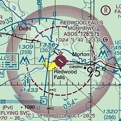
|
| Airport distance calculator |
|---|
|
|
| Sunrise and sunset |
|---|
|
Times for 01-Apr-2026
| | Local
(UTC-5) | | Zulu
(UTC) |
|---|
| Morning civil twilight | | 06:33 | | 11:33 |
| Sunrise | | 07:02 | | 12:02 |
| Sunset | | 19:46 | | 00:46 |
| Evening civil twilight | | 20:16 | | 01:16 |
|
| Current date and time |
|---|
| Zulu (UTC) | 01-Apr-2026 15:14:26 |
|---|
| Local (UTC-5) | 01-Apr-2026 10:14:26 |
|---|
|
| METAR |
|---|
| KRWF | 011453Z AUTO 08009G17KT 10SM SCT080 03/M05 A3020 RMK AO2 SLP237 T00281050 56014
|
KOVL
14nm N | 011455Z AUTO 10011G17KT 10SM OVC085 02/M05 A3020 RMK AO2
|
|
| TAF |
|---|
| KRWF | 011120Z 0112/0212 09008KT P6SM BKN150 FM011700 09012KT P6SM BKN080 FM012200 09013G21KT 5SM -RA OVC030 FM020100 09015G23KT 3SM -RA OVC015 FM020400 09015G25KT 2SM -RAPL OVC008 FM020900 08015G24KT 2SM -PL -FZRA OVC007
|
|
| NOTAMs |
|---|
NOTAMs are issued by the DoD/FAA and will open in a separate window not controlled by AirNav.
|
|

