FAA INFORMATION EFFECTIVE 19 MARCH 2026
Location
| FAA Identifier: | SLK |
| Lat/Long: | 44-23-07.1090N 074-12-22.2530W
44-23.118483N 074-12.370883W
44.3853081,-74.2061814
(estimated) |
| Elevation: | 1662.6 ft. / 506.8 m (surveyed) |
| Variation: | 14W (2015) |
| From city: | 4 miles NW of SARANAC LAKE, NY |
| Time zone: | UTC -4 (UTC -5 during Standard Time) |
| Zip code: | 12945 |
Airport Operations
| Airport use: | Open to the public |
| Activation date: | 12/1942 |
| Control tower: | no |
| ARTCC: | BOSTON CENTER |
| FSS: | BURLINGTON FLIGHT SERVICE STATION |
| NOTAMs facility: | SLK (NOTAM-D service available) |
| Attendance: | MAY-OCT 0600-2100, NOV-APR 0600-2000
FOR ARPT ATTENDANT AFTER HRS CALL 518-637-7329. |
| Wind indicator: | lighted |
| Segmented circle: | no |
| Lights: | ACTVT MALSR RWY 23; HIRL RWY 05/23, MIRL RWY 09/27 & TWY LGTS - CTAF. PAPI RWY 05 OPR CONSLY. |
| Beacon: | white-green (lighted land airport)
Operates sunset to sunrise. |
| Landing fee: | yes |
| Fire and rescue: | ARFF index A |
| Airline operations: | PPR 48 HR FOR UNSKED ACR OPNS WITH MORE THAN 30 PSGR SEATS CALL AMGR 518-891-4600 EXT. 106. INDEX "B" COVERAGE IS PROVIDED. |
| International operations: | customs landing rights airport |
Airport Communications
| CTAF/UNICOM: | 123.0 |
| WX ASOS: | 124.175 (518-891-6696) |
| WX AWOS-3PT at LKP (13 nm SE): | 118.025 (518-302-5422) |
- APCH/DEP SVC PRVDD BY BOSTON ARTCC ON FREQS 120.35/342.25 (ST. ALBANS RCAG).
Nearby radio navigation aids
| NDB name | | Hdg/Dist | | Freq | | Var | | ID |
|---|
| POTSDAM | | 139/35.3 | | 400 | | 14W | | PTD | .--. - -.. |
Airport Services
| Fuel available: | 100LL JET-A |
| Parking: | hangars and tiedowns |
| Airframe service: | MAJOR |
| Powerplant service: | MAJOR |
| Bottled oxygen: | NONE |
| Bulk oxygen: | NONE |
Runway Information
Runway 5/23
| Dimensions: | 6573 x 150 ft. / 2003 x 46 m |
| Surface: | asphalt/grooved, in good condition |
| Weight bearing capacity: | | Single wheel: | 40.0 | | Double wheel: | 73.0 | | Double tandem: | 115.0 |
|
| Runway edge lights: | high intensity |
| RUNWAY 5 | | RUNWAY 23 |
| Latitude: | 44-22.812493N | | 44-23.699623N |
| Longitude: | 074-12.796500W | | 074-11.933597W |
| Elevation: | 1640.0 ft. | | 1662.5 ft. |
| Traffic pattern: | left | | left |
| Runway heading: | 049 magnetic, 035 true | | 229 magnetic, 215 true |
| Declared distances: | TORA:6573 TODA:6573 ASDA:6573 LDA:6573 | | TORA:6573 TODA:6573 ASDA:6333 LDA:6333 |
| Markings: | nonprecision, in fair condition | | precision, in fair condition |
| Visual slope indicator: | 4-light PAPI on left (3.00 degrees glide path) | | |
| Approach lights: | | | MALSR: 1,400 foot medium intensity approach lighting system with runway alignment indicator lights |
| Touchdown point: | yes, no lights | | yes, no lights |
| Instrument approach: | | | ILS |
| Obstructions: | 18 ft. trees, 387 ft. from runway, 387 ft. left of centerline, 10:1 slope to clear | | 7 ft. trees, 385 ft. from runway, 532 ft. right of centerline, 26:1 slope to clear |
Runway 9/27
| Dimensions: | 3997 x 100 ft. / 1218 x 30 m |
| Surface: | asphalt, in good condition |
| Weight bearing capacity: | | Single wheel: | 40.0 | | Double wheel: | 73.0 | | Double tandem: | 115.0 |
|
| Runway edge lights: | medium intensity |
| Runway edge markings: | NSTD MKGS; THLD MKGS 400 FT FM RY END. |
| RUNWAY 9 | | RUNWAY 27 |
| Latitude: | 44-22.830187N | | 44-22.954312N |
| Longitude: | 074-12.830687W | | 074-11.929858W |
| Elevation: | 1638.8 ft. | | 1638.3 ft. |
| Traffic pattern: | left | | left |
| Runway heading: | 093 magnetic, 079 true | | 273 magnetic, 259 true |
| Displaced threshold: | no | | 400 ft. |
| Declared distances: | TORA:3997 TODA:3997 ASDA:3997 LDA:3997 | | TORA:3997 TODA:3997 ASDA:3997 LDA:3597 |
| Markings: | NSTD, in good condition | | nonprecision, in good condition |
| Touchdown point: | yes, no lights | | yes, no lights |
| Obstructions: | 27 ft. trees, 214 ft. from runway, 252 ft. left of centerline | | 18 ft. trees, 387 ft. from runway, 56 ft. left of centerline, 10:1 slope to clear |
Airport Ownership and Management from official FAA records
| Ownership: | Publicly-owned |
| Owner: | TOWN OF HARRIETSTOWN
39 MAIN STREET
SARANAC LAKE, NY 12983
Phone 518-891-1470 |
| Manager: | COREY HURWITCH
96 AIRPORT ROAD
SARANAC LAKE, NY 12983
Phone 518-891-4600 |
Additional Remarks
| A39-05/23 | PCR VALUE: 363/F/B/X/T |
| A39-09/27 | PCR VALUE: 349/F/A/X/T |
| - | RWY/TWY/APRON CONDS NOT MNT OUTSIDE OF NML ATND HRS. |
| - | TWY B UNAVBL TO ACFT WITH WINGSPAN 79 FT & ABV. |
| - | COLD TEMPERATURE AIRPORT. ALTITUDE CORRECTION REQUIRED AT OR BELOW -32C. |
| - | FOR CD IF UNA TO CTC ON FREQ, CTC BOSTON ARTCC AT 603-879-6859. |
| - | ALL SFCS WORK IN PROG; GRASS CUTTING APR THRU OCT. |
Instrument Procedures
NOTE: All procedures below are presented as PDF files. If you need a reader for these files, you should download the free Adobe Reader.NOT FOR NAVIGATION. Please procure official charts for flight.
FAA instrument procedures published for use from 19 March 2026 at 0901Z to 16 April 2026 at 0900Z.
IAPs - Instrument Approach Procedures |
|---|
| ILS OR LOC RWY 23 **CHANGED** | |
download (253KB) |
| RNAV (GPS) RWY 05 | |
download (227KB) |
| RNAV (GPS) RWY 09 | |
download (241KB) |
| RNAV (GPS) RWY 23 | |
download (235KB) |
| NOTE: Special Alternate Minimums apply | |
download (144KB) |
| NOTE: Special Take-Off Minimums/Departure Procedures apply | |
download (309KB) |
Other nearby airports with instrument procedures:
KLKP - Lake Placid Airport (13 nm SE)
KMAL - Malone-Dufort Airport (29 nm N)
KPBG - Plattsburgh International Airport (35 nm NE)
KPTD - Potsdam Municipal Airport/Damon Field (36 nm NW)
KMSS - Massena International Airport-Richards Field (43 nm NW)
|
|

Road maps at:
MapQuest
Bing
Google
| Aerial photo |
|---|
WARNING: Photo may not be current or correct
 Photo taken 21-Nov-2006
Do you have a better or more recent aerial photo of Adirondack Regional Airport that you would like to share? If so, please send us your photo.
|
| Sectional chart |
|---|
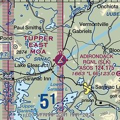
|
| Airport distance calculator |
|---|
|
|
| Sunrise and sunset |
|---|
|
Times for 14-Apr-2026
| | Local
(UTC-4) | | Zulu
(UTC) |
|---|
| Morning civil twilight | | 05:46 | | 09:46 |
| Sunrise | | 06:16 | | 10:16 |
| Sunset | | 19:39 | | 23:39 |
| Evening civil twilight | | 20:09 | | 00:09 |
|
| Current date and time |
|---|
| Zulu (UTC) | 14-Apr-2026 14:01:04 |
|---|
| Local (UTC-4) | 14-Apr-2026 10:01:04 |
|---|
|
| METAR |
|---|
| KSLK | 141351Z AUTO 17003KT 10SM BKN014 OVC019 13/10 A2992 RMK AO2 SLP132 T01330100
|
KLKP
13nm SE | 141335Z AUTO VRB02KT 10SM BKN022 15/10 A2996 RMK AO2
|
|
| TAF |
|---|
| KSLK | 141120Z 1412/1512 00000KT P6SM SCT005 OVC020 TEMPO 1412/1413 5SM -SHRA BR BKN005 OVC020 FM141300 19009KT P6SM SCT030 BKN060 WS020/24035KT PROB30 1414/1417 5SM -SHRA BR BKN030 FM141800 20010G17KT 5SM -TSRA BR SCT030 OVC045CB FM142100 24010G21KT 5SM -TSRA BR OVC018CB WS020/24045KT FM150100 25007KT 5SM BR BKN009 BKN011
|
|
| NOTAMs |
|---|
NOTAMs are issued by the DoD/FAA and will open in a separate window not controlled by AirNav.
|
|

