FAA INFORMATION EFFECTIVE 30 OCTOBER 2025
Location
| FAA Identifier: | UXL |
| Lat/Long: | 30-07-53.2000N 093-22-34.2000W
30-07.886667N 093-22.570000W
30.1314444,-93.3761667
(estimated) |
| Elevation: | 10.2 ft. / 3 m (estimated) |
| Variation: | 04E (1995) |
| From city: | 5 miles S of SULPHUR, LA |
| Time zone: | UTC -6 (UTC -5 during Daylight Saving Time) |
| Zip code: | 70665 |
Airport Operations
| Airport use: | Open to the public |
| Activation date: | 08/1987 |
| Control tower: | no |
| ARTCC: | HOUSTON CENTER |
| FSS: | DE RIDDER FLIGHT SERVICE STATION |
| NOTAMs facility: | UXL (NOTAM-D service available) |
| Attendance: | 0600-2000 |
| Wind indicator: | lighted |
| Segmented circle: | yes |
| Lights: | ODALS RWY 15; REIL RWY 33; MIRL RWY 15/33 PRESET LOW INTST DUSK-DAWN. TO INCR INTST - CTAF. PAPI RWY 15 & 33 OPR CONSLY. |
| Beacon: | white-green (lighted land airport)
Operates sunset to sunrise. |
Airport Communications
| CTAF/UNICOM: | 122.8 |
| WX AWOS-3PT: | 118.175 (337-558-5321) |
| LAKE CHARLES APPROACH: | 119.35 |
| LAKE CHARLES DEPARTURE: | 119.35 |
| WX ASOS at LCH (8 nm E): | PHONE 337-240-9596 |
| WX AWOS-3 at CWF (13 nm E): | 120.0 (337-214-2134) |
| WX AWOS-3PT at 5R8 (19 nm N): | 121.2 (337-786-1518) |
- APCH/DEP SVC PRVDD BY HOUSTON ARTCC (ZHU) ON FREQS 124.7/317.4 (LAKE CHARLES RCAG) WHEN LAKE CHARLES APCH CTL (LCH) CLSD.
Nearby radio navigation aids
| VOR radial/distance | | VOR name | | Freq | | Var |
|---|
| LCHr261/14.1 | | LAKE CHARLES VORTAC | | 113.40 | | 07E |
| NDB name | | Hdg/Dist | | Freq | | Var | | ID |
|---|
| SULPHUR | | 146/4.6 | | 278 | | 04E | | AUR | .- ..- .-. |
| MOSSY | | 222/14.1 | | 418 | | 00E | | CW | -.-. .-- |
Airport Services
| Fuel available: | 100LL JET-A
100LL:FOR FUEL AFT HRS CALL 337-302-4280; FEE CHARGED. |
| Parking: | hangars and tiedowns |
| Airframe service: | MAJOR |
| Powerplant service: | MAJOR |
Runway Information
Runway 15/33
| Dimensions: | 5001 x 75 ft. / 1524 x 23 m |
| Surface: | asphalt, in good condition |
| Weight bearing capacity: | | Single wheel: | 30.0 | | Double wheel: | 50.0 |
|
| Runway edge lights: | medium intensity |
| RUNWAY 15 | | RUNWAY 33 |
| Latitude: | 30-08.244557N | | 30-07.527348N |
| Longitude: | 093-22.805118W | | 093-22.335982W |
| Elevation: | 9.2 ft. | | 9.7 ft. |
| Traffic pattern: | left | | left |
| Runway heading: | 146 magnetic, 150 true | | 326 magnetic, 330 true |
| Markings: | nonprecision, in fair condition | | nonprecision, in fair condition |
| Visual slope indicator: | 4-light PAPI on left (3.00 degrees glide path) | | 4-light PAPI on left (3.00 degrees glide path) |
| Approach lights: | ODALS: omnidirectional approach lighting system | | |
| Runway end identifier lights: | no | | yes |
| Touchdown point: | yes, no lights | | yes, no lights |
| Instrument approach: | LOCALIZER | | |
| Obstructions: | 33 ft. tree, 991 ft. from runway, 322 ft. right of centerline, 23:1 slope to clear | | 45 ft. tree, 1758 ft. from runway, 34:1 slope to clear |
Airport Ownership and Management from official FAA records
| Ownership: | Publicly-owned |
| Owner: | W. CALCASIEU MANAGING AIRPORT BOARD
7000 SOUTHLAND FIELD ROAD
SULPHUR, LA 70665
Phone 337-607-4550 |
| Manager: | TIM LAFLEUR
7000 SOUTHLAND FIELD ROAD
SULPHUR, LA 70665
Phone 337-607-4550 |
Additional Remarks
| - | FOR CD CTC LAKE CHARLES APCH AT 337-480-3103, WHEN APCH CLSD CTC HOUSTON ARTCC AT 281-230-5622. |
| - | CTC ARPT MGR FOR DSNGD RAMP SPACE FOR PUB USE AT ARPT |
Instrument Procedures
NOTE: All procedures below are presented as PDF files. If you need a reader for these files, you should download the free Adobe Reader.NOT FOR NAVIGATION. Please procure official charts for flight.
FAA instrument procedures published for use from 30 October 2025 at 0901Z to 27 November 2025 at 0900Z.
IAPs - Instrument Approach Procedures |
|---|
| RNAV (GPS) RWY 15 | |
download (280KB) |
| RNAV (GPS) RWY 33 | |
download (290KB) |
| LOC RWY 15 | |
download (277KB) |
| NOTE: Special Alternate Minimums apply | |
download (159KB) |
| NOTE: Special Take-Off Minimums/Departure Procedures apply | |
download (309KB) |
Other nearby airports with instrument procedures:
KLCH - Lake Charles Regional Airport (8 nm E)
KCWF - Chennault International Airport (13 nm E)
5R8 - De Quincy Industrial Airpark (19 nm N)
KORG - Orange County Airport (23 nm W)
6R1 - Welsh Airport (29 nm E)
|
|

Road maps at:
MapQuest
Bing
Google
| Aerial photo |
|---|
WARNING: Photo may not be current or correct
 Photo by Mark Congco
Photo taken 11-Jun-2019
looking east.
Photo by Mark Congco
Photo taken 11-Jun-2019
looking east.
Do you have a better or more recent aerial photo of Southland Field Airport that you would like to share? If so, please send us your photo.
|
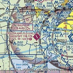
| Sectional chart |
|---|
|
| Airport distance calculator |
|---|
|
|
| Sunrise and sunset |
|---|
|
Times for 18-Nov-2025
| | Local
(UTC-6) | | Zulu
(UTC) |
|---|
| Morning civil twilight | | 06:17 | | 12:17 |
| Sunrise | | 06:42 | | 12:42 |
| Sunset | | 17:15 | | 23:15 |
| Evening civil twilight | | 17:41 | | 23:41 |
|
| Current date and time |
|---|
| Zulu (UTC) | 18-Nov-2025 09:36:29 |
|---|
| Local (UTC-6) | 18-Nov-2025 03:36:29 |
|---|
|
| METAR |
|---|
| KUXL | 180915Z AUTO 00000KT 1/2SM FG BKN004 20/20 A3000 RMK AO2 T01960196
|
KLCH
8nm E | 180853Z AUTO 14006KT 7SM CLR 18/18 A2999 RMK AO2 SLP162 T01830183 58005
|
KCWF
13nm NE | 180915Z AUTO 15005KT 7SM BR CLR 19/19 A3000 RMK AO2 T01880186
|
K5R8
19nm N | 180915Z AUTO 00000KT 1/2SM FG OVC003 16/16 A3000 RMK AO2 T01630159
|
|
| TAF |
|---|
KLCH
8nm E | 180539Z 1806/1906 15005KT P6SM SKC TEMPO 1808/1811 3SM BR FM181400 17007KT P6SM BKN250
|
|
| NOTAMs |
|---|
NOTAMs are issued by the DoD/FAA and will open in a separate window not controlled by AirNav.
|
|

