FAA INFORMATION EFFECTIVE 14 MAY 2026
Location
| FAA Identifier: | 5R8 |
| Lat/Long: | 30-26-27.9000N 093-28-25.0000W
30-26.465000N 093-28.416667W
30.4410833,-93.4736111
(estimated) |
| Elevation: | 82.8 ft. / 25.2 m (surveyed) |
| Variation: | 02E (2010) |
| From city: | 2 miles SW of DE QUINCY, LA |
| Time zone: | UTC -5 (UTC -6 during Standard Time) |
| Zip code: | 70633 |
Airport Operations
| Airport use: | Open to the public |
| Control tower: | no |
| ARTCC: | HOUSTON CENTER |
| FSS: | DE RIDDER FLIGHT SERVICE STATION |
| NOTAMs facility: | 5R8 (NOTAM-D service available) |
| Attendance: | MON-THURS 0700-1600, ALL FRI 0700-1100 |
| Wind indicator: | lighted |
| Segmented circle: | yes |
| Lights: | MIRL RY 16/34, REIL RYS 16 & 34 PRESET LOW INTST DUSK-DAWN; TO INCR INTST ACTVT - CTAF. |
| Beacon: | white-green (lighted land airport)
Operates sunset to sunrise. |
Airport Communications
| CTAF/UNICOM: | 122.8 |
| WX AWOS-3PT: | 121.2 (337-786-1518) |
| LAKE CHARLES APPROACH: | 119.35 |
| LAKE CHARLES DEPARTURE: | 119.35 |
| WX AWOS-3PT at UXL (19 nm S): | 118.175 (337-558-5321) |
- APCH/DEP SVC PRVDD BY HOUSTON ARTCC (ZHU) ON FREQS 124.7/317.4 (LAKE CHARLES RCAG) WHEN LAKE CHARLES APCH CTL (LCH) CLSD.
Nearby radio navigation aids
| VOR radial/distance | | VOR name | | Freq | | Var |
|---|
| LCHr306/26.2 | | LAKE CHARLES VORTAC | | 113.40 | | 07E |
| NDB name | | Hdg/Dist | | Freq | | Var | | ID |
|---|
| SULPHUR | | 345/14.8 | | 278 | | 04E | | AUR | .- ..- .-. |
Airport Services
| Fuel available: | 100LL
100LL:SELF SERVICE FUEL WITH CREDIT CARD. |
| Parking: | hangars and tiedowns |
| Airframe service: | MINOR
EMERG AIRFRAME RPR AVBL CALL ARPT MGR FOR DETAILS. |
| Powerplant service: | MINOR
EMERG PWR PLANT RPR AVBL CALL ARPT MGR FOR DETAILS. |
| Bottled oxygen: | NONE |
| Bulk oxygen: | NONE |
Runway Information
Runway 16/34
| Dimensions: | 4997 x 75 ft. / 1523 x 23 m |
| Surface: | asphalt, in good condition |
| Weight bearing capacity: | |
| Runway edge lights: | medium intensity |
| RUNWAY 16 | | RUNWAY 34 |
| Latitude: | 30-26.845035N | | 30-26.084465N |
| Longitude: | 093-28.600015W | | 093-28.232992W |
| Elevation: | 72.7 ft. | | 80.7 ft. |
| Traffic pattern: | left | | left |
| Runway heading: | 155 magnetic, 157 true | | 335 magnetic, 337 true |
| Markings: | nonprecision, in good condition | | nonprecision, in good condition |
| Visual slope indicator: | 2-light PAPI on left (3.00 degrees glide path) | | 2-light PAPI on left (3.00 degrees glide path) |
| Runway end identifier lights: | yes | | yes |
| Touchdown point: | yes, no lights | | yes, no lights |
| Obstructions: | 59 ft. tree, 1468 ft. from runway, 21:1 slope to clear | | 43 ft. trees, 1573 ft. from runway, 280 ft. right of centerline, 31:1 slope to clear |
Airport Ownership and Management from official FAA records
| Ownership: | Publicly-owned |
| Owner: | CITY OF DE QUINCY
PO BOX 968
DE QUINCY, LA 70633
Phone 337-786-8211 |
| Manager: | KYLE RAINWATER
PO BOX 968
DE QUINCY, LA 70633
Phone 337-660-3488 |
Additional Remarks
| - | FOR CD CTC LAKE CHARLES APCH AT 337-480-3103, WHEN APCH CLSD CTC HOUSTON ARTCC AT 281-230-5622. |
| - | COURTESY CAR AND PILOTS LOUNGE AVBL. |
| - | CTC APRT MGR FOR DSGND RAMP SPACE FOR PUB USE. |
Instrument Procedures
NOTE: All procedures below are presented as PDF files. If you need a reader for these files, you should download the free Adobe Reader.NOT FOR NAVIGATION. Please procure official charts for flight.
FAA instrument procedures published for use from 14 May 2026 at 0901Z to 11 June 2026 at 0900Z.
IAPs - Instrument Approach Procedures |
|---|
| RNAV (GPS) RWY 16 | |
download (239KB) |
| RNAV (GPS) RWY 34 | |
download (231KB) |
| NOTE: Special Take-Off Minimums/Departure Procedures apply | |
download (167KB) |
Other nearby airports with instrument procedures:
KUXL - Southland Field Airport (19 nm S)
KCWF - Chennault International Airport (22 nm SE)
KLCH - Lake Charles Regional Airport (23 nm SE)
KDRI - Beauregard Regional Airport (24 nm N)
KORG - Orange County Airport (28 nm SW)
|
|

Road maps at:
MapQuest
Bing
Google
| Aerial photo |
|---|

|
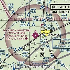
| Sectional chart |
|---|
|
| Airport distance calculator |
|---|
|
|
| Sunrise and sunset |
|---|
|
Times for 08-Jun-2026
| | Local
(UTC-5) | | Zulu
(UTC) |
|---|
| Morning civil twilight | | 05:45 | | 10:45 |
| Sunrise | | 06:12 | | 11:12 |
| Sunset | | 20:14 | | 01:14 |
| Evening civil twilight | | 20:41 | | 01:41 |
|
| Current date and time |
|---|
| Zulu (UTC) | 09-Jun-2026 02:40:46 |
|---|
| Local (UTC-5) | 08-Jun-2026 21:40:46 |
|---|
|
| METAR |
|---|
| K5R8 | 090215Z AUTO 00000KT 10SM SCT023 24/22 A3005 RMK AO2 T02430218
|
|
| TAF |
|---|
KLCH
23nm SE | 081739Z 0818/0918 17010KT P6SM FEW025 BKN150 FM090100 14004KT P6SM OVC250 FM091200 VRB03KT P6SM BKN250
|
|
| NOTAMs |
|---|
NOTAMs are issued by the DoD/FAA and will open in a separate window not controlled by AirNav.
|
|

