FAA INFORMATION EFFECTIVE 09 JULY 2026
Location
| FAA Identifier: | VTI |
| Lat/Long: | 42-13-07.1000N 092-01-33.3000W
42-13.118333N 092-01.555000W
42.2186389,-92.0259167
(estimated) |
| Elevation: | 842 ft. / 256.6 m (surveyed) |
| Variation: | 01E (2000) |
| From city: | 3 miles N of VINTON, IA |
| Time zone: | UTC -5 (UTC -6 during Standard Time) |
| Zip code: | 52349 |
Airport Operations
| Airport use: | Open to the public |
| Activation date: | 09/1964 |
| Control tower: | no |
| ARTCC: | CHICAGO CENTER |
| FSS: | FORT DODGE FLIGHT SERVICE STATION |
| NOTAMs facility: | VTI (NOTAM-D service available) |
| Attendance: | UNATNDD |
| Wind indicator: | lighted |
| Segmented circle: | no |
| Lights: | PILOT CONTROLED MIRL RWY 09/27; TO ACTVT & ACTVT PAPI RWYS 09 & 27 AND REIL RWYS 09 & 27 - CTAF. |
| Beacon: | white-green (lighted land airport)
Operates sunset to sunrise. |
Airport Communications
| CTAF/UNICOM: | 122.8 |
| WX AWOS-3: | 120.075 (319-472-3122) |
| CEDAR RAPIDS APPROACH: | 134.05 [0600-2130] |
| CEDAR RAPIDS DEPARTURE: | 134.05 [0600-2130] |
| WX AWOS-3 at IIB (15 nm N): | 120.825 (319-334-3879) |
- APCH/DEP SVC PRVDD BY CHICAGO ARTCC ON FREQS 132.8/328.4 (CEDAR RAPIDS RCAG) WHEN CEDAR RAPIDS APCH CTL CLSD.
Nearby radio navigation aids
| VOR radial/distance | | VOR name | | Freq | | Var |
|---|
| CIDr327/22.6 | | CEDAR RAPIDS VOR/DME | | 114.10 | | 05E |
| ALOr141/26.2 | | WATERLOO VOR/DME | | 112.20 | | 00E |
Airport Services
| Fuel available: | 100LL JET-A MOGAS
100LL:SELF SVC FUEL AVBL 24 HRS.
A:SELF SVC FUEL AVBL 24 HRS.
MOGAS:SELF SVC FUEL AVBL 24 HRS. |
| Parking: | tiedowns |
| Airframe service: | MINOR |
| Powerplant service: | MINOR |
| Bottled oxygen: | NONE |
| Bulk oxygen: | NONE |
Runway Information
Runway 9/27
| Dimensions: | 4000 x 60 ft. / 1219 x 18 m |
| Surface: | concrete, in fair condition |
| Weight bearing capacity: | |
| Runway edge lights: | medium intensity |
| RUNWAY 9 | | RUNWAY 27 |
| Latitude: | 42-13.171002N | | 42-13.142250N |
| Longitude: | 092-02.122233W | | 092-01.237070W |
| Elevation: | 824.0 ft. | | 838.2 ft. |
| Traffic pattern: | left | | left |
| Runway heading: | 091 magnetic, 092 true | | 272 magnetic, 273 true |
| Markings: | nonprecision, in good condition | | nonprecision, in good condition |
| Visual slope indicator: | 2-light PAPI on left (4.00 degrees glide path) | | 2-light PAPI on left (3.00 degrees glide path) |
| Runway end identifier lights: | yes | | yes |
| Touchdown point: | yes, no lights | | yes, no lights |
| Obstructions: | 53 ft. tree, 1451 ft. from runway, 141 ft. left of centerline, 23:1 slope to clear | | 45 ft. tree, 1186 ft. from runway, 178 ft. left of centerline, 21:1 slope to clear |
Runway 16/34
| Dimensions: | 2500 x 50 ft. / 762 x 15 m |
| Surface: | asphalt, in good condition |
| Weight bearing capacity: | | PCN 3 /F/D/X/T | | Single wheel: | 12.5 |
|
| RUNWAY 16 | | RUNWAY 34 |
| Latitude: | 42-13.248920N | | 42-12.861883N |
| Longitude: | 092-01.451287W | | 092-01.262612W |
| Elevation: | 833.4 ft. | | 838.1 ft. |
| Traffic pattern: | left | | left |
| Runway heading: | 160 magnetic, 161 true | | 340 magnetic, 341 true |
| Displaced threshold: | no | | 190 ft. |
| Markings: | basic, in good condition | | basic, in good condition |
| Touchdown point: | yes, no lights | | yes, no lights |
| Obstructions: | none | | 36 ft. trees, 484 ft. from runway, 99 ft. right of centerline, 7:1 slope to clear
RWY 34 APCH 18:1 AT DTHR. |
Airport Ownership and Management from official FAA records
| Ownership: | Publicly-owned |
| Owner: | CITY OF VINTON
PO BOX 529
VINTON, IA 52349
Phone 319-472-4707 |
| Manager: | MICHAEL J. MYERS
CITY HALL - P.O. BOX 529
VINTON, IA 52349
Phone 319-472-4707
CHAIRMAN, ARPT CMSN. MGR NOT AT FIELD. |
Additional Remarks
| - | RY 16/34 CLSD NIGHTS AND USED AS TWY FM RY 09/27 TO RAMP. |
| - | WILDLIFE INVOF ARPT. |
| - | FOR CD CTC CHICAGO ARTCC AT 630-906-8921. |
Instrument Procedures
NOTE: All procedures below are presented as PDF files. If you need a reader for these files, you should download the free Adobe Reader.NOT FOR NAVIGATION. Please procure official charts for flight.
FAA instrument procedures published for use from 09 July 2026 at 0901Z to 06 August 2026 at 0900Z.
IAPs - Instrument Approach Procedures |
|---|
| RNAV (GPS) RWY 09 | |
download (201KB) |
| RNAV (GPS) RWY 27 | |
download (262KB) |
| NOTE: Special Alternate Minimums apply | |
download (133KB) |
| NOTE: Special Take-Off Minimums/Departure Procedures apply | |
download (431KB) |
Other nearby airports with instrument procedures:
KIIB - James H Connell Field at Independence Municipal Airport (15 nm N)
KTZT - Belle Plaine Municipal Airport (23 nm SW)
KCID - The Eastern Iowa Airport (24 nm SE)
C17 - Marion Airport (25 nm SE)
KALO - Waterloo Regional Airport (26 nm NW)
|
|

Road maps at:
MapQuest
Bing
Google
| Aerial photo |
|---|
WARNING: Photo may not be current or correct
 Photo by Tavo Gutierrez
Photo taken 03-Jul-2011
looking south.
Photo by Tavo Gutierrez
Photo taken 03-Jul-2011
looking south.
Do you have a better or more recent aerial photo of Vinton Veterans Memorial Airpark that you would like to share? If so, please send us your photo.
|
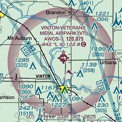
| Sectional chart |
|---|
|
| Airport distance calculator |
|---|
|
|
| Sunrise and sunset |
|---|
|
Times for 02-Aug-2026
| | Local
(UTC-5) | | Zulu
(UTC) |
|---|
| Morning civil twilight | | 05:31 | | 10:31 |
| Sunrise | | 06:03 | | 11:03 |
| Sunset | | 20:26 | | 01:26 |
| Evening civil twilight | | 20:57 | | 01:57 |
|
| Current date and time |
|---|
| Zulu (UTC) | 02-Aug-2026 19:50:49 |
|---|
| Local (UTC-5) | 02-Aug-2026 14:50:49 |
|---|
|
| METAR |
|---|
KIIB
15nm N | 021935Z AUTO 36006KT 10SM BKN030 25/19 A2998 RMK AO2 T02530188
|
|
| TAF |
|---|
KCID
24nm SE | 021720Z 0218/0318 02008KT P6SM SCT020 FM030200 VRB03KT P6SM FEW100
|
KALO
26nm NW | 021739Z 0218/0318 05007KT P6SM SCT028 SCT250 TEMPO 0218/0220 BKN028 FM030200 09003KT P6SM FEW250 FM030900 13003KT P6SM FEW250 FM031400 15006KT P6SM FEW030
|
|
| NOTAMs |
|---|
NOTAMs are issued by the DoD/FAA and will open in a separate window not controlled by AirNav.
|
|

