FAA INFORMATION EFFECTIVE 17 APRIL 2025
Location
| FAA Identifier: | L94 |
| Lat/Long: | 35-06-03.8800N 118-25-23.3010W
35-06.064667N 118-25.388350W
35.1010778,-118.4231392
(estimated) |
| Elevation: | 4220 ft. / 1286 m (estimated) |
| Variation: | 14E (1985) |
| From city: | 2 miles SE of TEHACHAPI, CA |
| Time zone: | UTC -7 (UTC -8 during Standard Time) |
| Zip code: | 93561 |
Airport Operations
| Airport use: | Open to the public |
| Activation date: | 02/1968 |
| Control tower: | no |
| ARTCC: | LOS ANGELES CENTER |
| FSS: | RANCHO MURIETA FLIGHT SERVICE STATION |
| NOTAMs facility: | RIU (NOTAM-D service available) |
| Attendance: | DAWN-DUSK |
| Wind indicator: | yes |
| Segmented circle: | yes |
Airport Communications
| CTAF/UNICOM: | 123.0 |
| WX AWOS-3P at TSP (2.2 nm N): | 120.025 (661-823-0473) |
| WX AWOS-3 at MHV (14 nm E): | 132.225 (661-824-5218) |
Nearby radio navigation aids
| VOR radial/distance | | VOR name | | Freq | | Var |
|---|
| LHSr002/26.2 | | LAKE HUGHES VORTAC | | 114.35 | | 15E |
| GMNr034/28.0 | | GORMAN VORTAC | | 116.10 | | 16E |
| PMDr313/33.3 | | PALMDALE VORTAC | | 115.55 | | 15E |
| EDWr270/34.7 | | EDWARDS VORTAC | | 116.40 | | 12E |
Airport Services
| Parking: | tiedowns |
| Airframe service: | MAJOR |
| Powerplant service: | MAJOR |
| Bottled oxygen: | LOW |
| Bulk oxygen: | LOW |
Runway Information
Runway 9L/27R
| Dimensions: | 4890 x 36 ft. / 1490 x 11 m
RY END 09L FIRST 1,200 FT X 36 FT DIRT; RY END 27R REMAINING 3,690 FT ASPHALT OF VARYING WIDTHS. |
| Surface: | asphalt/dirt, in fair condition |
| Runway edge markings: | NON STANDARD THRESHOLD MARKING ONLY
NO RUNWAY CENTERLINE |
| Operational restrictions: | RESTRICTED TO SAILPLANE USE. |
| RUNWAY 9L | | RUNWAY 27R |
| Traffic pattern: | left | | right |
| Markings: | NSTD | | NSTD |
| Runway end identifier lights: | no | | no |
| Obstructions: | 37 ft. road, 1240 ft. from runway, 250 ft. left of centerline, 33:1 slope to clear | | 18 ft. berm, 510 ft. from runway, 155 ft. right of centerline, 17:1 slope to clear |
Runway 9R/27L
| Dimensions: | 4890 x 36 ft. / 1490 x 11 m
PARTIALLY PAVED PORTIONS OF THE RUNWAY 20 FEET WIDE |
| Surface: | asphalt/dirt, in fair condition |
| RUNWAY 9R | | RUNWAY 27L |
| Traffic pattern: | right | | left |
| Markings: | NSTD, in fair condition | | NSTD, in good condition |
| Runway end identifier lights: | no | | no |
| Obstructions: | 79 ft. tree, 2140 ft. from runway, 120 ft. right of centerline, 27:1 slope to clear | | 18 ft. berm, 560 ft. from runway, 160 ft. right of centerline, 20:1 slope to clear |
Airport Ownership and Management from official FAA records
| Ownership: | Privately-owned |
| Owner: | JANE BARRETT
PO BOX 100
TEHACHAPI, CA 93581
Phone 661-822-5267 |
| Manager: | JANE BARRETT
16334 HARRIS ROAD
TEHACHAPI, CA 93561
Phone 661-822-5267
ALTERNATE CONTACT: MRS. JANE BARRETT |
Additional Remarks
| - | GLIDERS APCH FM N, USE RWY 9L/27R; PWR ACFT APCH FM S, USE RWY 9R/27L. |
| - | RY 09R/27L MARKED WITH NSTD THLD BARS EACH END; NO NUMBERS NO CNTRLN. |
| - | FOR CD CTC JOSHUA APCH AT 661-277-3843. |
Instrument Procedures
There are no published instrument procedures at L94.
Some nearby airports with instrument procedures:
KMHV - Mojave Air & Space Port/Rutan Field (14 nm E)
L71 - California City Municipal Airport (20 nm E)
KWJF - General Wm J Fox Airfield (24 nm SE)
KEDW - Edwards Air Force Base (29 nm SE)
L45 - Bakersfield Municipal Airport (31 nm NW)
|
|

Road maps at:
MapQuest
Bing
Google
| Aerial photo |
|---|
WARNING: Photo may not be current or correct
 Photo courtesy of FocalFlight.com
Photo taken 27-Jul-2008
Photo courtesy of FocalFlight.com
Photo taken 27-Jul-2008
Do you have a better or more recent aerial photo of Mountain Valley Airport that you would like to share? If so, please send us your photo.
|
| Sectional chart |
|---|
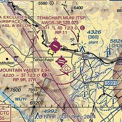
|
| Airport distance calculator |
|---|
|
|
| Sunrise and sunset |
|---|
|
Times for 25-Apr-2025
| | Local
(UTC-7) | | Zulu
(UTC) |
|---|
| Morning civil twilight | | 05:44 | | 12:44 |
| Sunrise | | 06:10 | | 13:10 |
| Sunset | | 19:33 | | 02:33 |
| Evening civil twilight | | 20:00 | | 03:00 |
|
| Current date and time |
|---|
| Zulu (UTC) | 25-Apr-2025 20:10:31 |
|---|
| Local (UTC-7) | 25-Apr-2025 13:10:31 |
|---|
|
| METAR |
|---|
KTSP
2nm N | 251955Z AUTO 32012G18KT 10SM SCT014 09/05 A2994 RMK AO2
|
KMHV
14nm E | 251940Z AUTO 26016KT 10SM CLR 16/02 A2989 RMK AO2
|
|
| TAF |
|---|
KWJF
25nm SE | 251720Z 2518/2618 23018G25KT P6SM FEW250 FM252000 23025G35KT P6SM FEW250 FM260100 23015G25KT P6SM FEW250 FM260900 23014KT P6SM SCT050 FM261700 23015G22KT 6SM -RA BR OVC050
|
KEDW
30nm SE | 251255Z 2513/2619 23015G25KT 9999 FEW150 FEW200 520009 520903 QNH2985INS BECMG 2516/2517 24018G28KT 9999 FEW200 520009 520903 QNH2989INS BECMG 2518/2519 24021G30KT 9999 FEW200 520009 520903 QNH2987INS BECMG 2520/2521 23024G34KT 9999 FEW200 520009 520903 QNH2986INS BECMG 2603/2604 25020G30KT 9999 FEW200 520009 520903 QNH2989INS BECMG 2610/2611 25015G25KT 9999 SCT050 SCT120 510009 510903 QNH2995INS BECMG 2617/2618 25017G28KT 8000 -SHRA BKN030 BKN120 520009 520903 QNH2999INS TX18/2522Z TN09/2514Z
|
|
| NOTAMs |
|---|
NOTAMs are issued by the DoD/FAA and will open in a separate window not controlled by AirNav.
|
|


