FAA INFORMATION EFFECTIVE 19 FEBRUARY 2026
Location
| FAA Identifier: | L45 |
| Lat/Long: | 35-19-29.5490N 118-59-45.6790W
35-19.492483N 118-59.761317W
35.3248747,-118.9960219
(estimated) |
| Elevation: | 378.3 ft. / 115.3 m (surveyed) |
| Variation: | 14E (1990) |
| From city: | 3 miles S of BAKERSFIELD, CA |
| Time zone: | UTC -8 (UTC -7 during Daylight Saving Time) |
| Zip code: | 93307 |
Airport Operations
| Airport use: | Open to the public |
| Activation date: | 06/1947 |
| Control tower: | no |
| ARTCC: | LOS ANGELES CENTER |
| FSS: | RANCHO MURIETA FLIGHT SERVICE STATION |
| NOTAMs facility: | RIU (NOTAM-D service available) |
| Attendance: | 0700-1700 |
| Pattern altitude: | 1178.3 ft. MSL |
| Wind indicator: | lighted |
| Segmented circle: | yes |
| Lights: | ACTVT REIL RWY 16 AND RWY 34; MIRL RWY 16/34 - CTAF. PAPI RWY 34 OPER CONSLY. ACTVT MIRL RWY 16/34 THREE CLICKS FOR ON; LGTS GO OUT AFTER 15 MINS. |
| Beacon: | white-green (lighted land airport)
Operates sunset to sunrise. |
Airport Communications
| CTAF/UNICOM: | 122.8 |
| BAKERSFIELD APPROACH: | 126.45 |
| BAKERSFIELD DEPARTURE: | 126.45 |
| WX ASOS at BFL (7 nm NW): | PHONE 661-246-3170 |
| WX AWOS-3 at MIT (15 nm NW): | 121.125 (661-393-8596) |
- APCH/DEP CTL SVC PRVDD BY LOS ANGELES ARTCC ARTCC (ZLA) ON FREQS 127.1/317.7 (BAKERSFIELD RCAG) WHEN BAKERSFIELD APCH CTL (BFL) CLSD.
Nearby radio navigation aids
| VOR radial/distance | | VOR name | | Freq | | Var |
|---|
| EHFr139/10.8 | | SHAFTER VORTAC | | 115.40 | | 14E |
| GMNr332/31.9 | | GORMAN VORTAC | | 116.10 | | 16E |
| TTEr162/35.3 | | TULE VOR/DME | | 116.25 | | 16E |
Airport Services
| Fuel available: | 100LL JET-A
A:FULL SERVICE USING FUELING TRUCK. |
| Parking: | tiedowns |
| Airframe service: | MAJOR |
| Powerplant service: | MAJOR |
Runway Information
Runway 16/34
| Dimensions: | 4000 x 75 ft. / 1219 x 23 m
150 FT PAVED STOPWAY AT EACH END OF RWY. |
| Surface: | asphalt, in good condition |
| Weight bearing capacity: | |
| Runway edge lights: | medium intensity |
| RUNWAY 16 | | RUNWAY 34 |
| Latitude: | 35-19.820665N | | 35-19.164310N |
| Longitude: | 118-59.799475W | | 118-59.723173W |
| Elevation: | 378.3 ft. | | 372.3 ft. |
| Traffic pattern: | right | | left |
| Runway heading: | 161 magnetic, 175 true | | 341 magnetic, 355 true |
| Markings: | nonprecision, in good condition | | nonprecision, in good condition |
| Visual slope indicator: | | | 2-light PAPI on left (4.10 degrees glide path) |
| Runway end identifier lights: | yes | | yes |
| Touchdown point: | yes, no lights | | yes, no lights |
| Obstructions: | 15 ft. road, 650 ft. from runway, 170 ft. left of centerline, 30:1 slope to clear | | 103 ft. pline, marked, 2500 ft. from runway, 22:1 slope to clear |
Airport Ownership and Management from official FAA records
| Ownership: | Publicly-owned |
| Owner: | CITY OF BAKERSFIELD
1501 TRUXTUN AVE
BAKERSFIELD, CA 93301
Phone 661-326-3781 |
| Manager: | KEVIN PEOPLES
4101 TRUXTUN AVENUE
BAKERSFIELD, CA 93309
Phone 661-326-3781
EMERGENCY 661-327-7111 |
Additional Remarks
| E98 | ALSO ONE HEX HANGER & 20 OPEN - SHADE HANGARS. |
| - | +100 FT POLE LINE 1/2 MILE SOUTH OF ARPT. |
| - | FOR CD CTC LOS ANGELES ARTCC AT 661-575-2079. |
Instrument Procedures
NOTE: All procedures below are presented as PDF files. If you need a reader for these files, you should download the free Adobe Reader.NOT FOR NAVIGATION. Please procure official charts for flight.
FAA instrument procedures published for use from 19 February 2026 at 0901Z to 19 March 2026 at 0900Z.
IAPs - Instrument Approach Procedures |
|---|
| RNAV (GPS) RWY 34 | |
download (283KB) |
| VOR/DME RWY 34 | |
download (232KB) |
Departure Procedures |
|---|
| STIGR TWO | |
download (147KB) |
| NOTE: Special Take-Off Minimums/Departure Procedures apply | |
download (135KB) |
Other nearby airports with instrument procedures:
KBFL - Meadows Field Airport (7 nm NW)
KMIT - Shafter Airport-Minter Field (15 nm NW)
KDLO - Delano Municipal Airport (28 nm NW)
KPTV - Porterville Municipal Airport (42 nm N)
KMHV - Mojave Air & Space Port/Rutan Field (44 nm E)
|
|

Road maps at:
MapQuest
Bing
Google
| Aerial photo |
|---|
WARNING: Photo may not be current or correct
 Photo courtesy of focalflight.com
Photo taken 08-Apr-2015
looking north.
Photo courtesy of focalflight.com
Photo taken 08-Apr-2015
looking north.
Do you have a better or more recent aerial photo of Bakersfield Municipal Airport that you would like to share? If so, please send us your photo.
|
| Sectional chart |
|---|
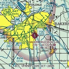
|
CAUTION: Diagram may not be current

| Airport distance calculator |
|---|
|
|
| Sunrise and sunset |
|---|
|
Times for 21-Feb-2026
| | Local
(UTC-8) | | Zulu
(UTC) |
|---|
| Morning civil twilight | | 06:11 | | 14:11 |
| Sunrise | | 06:37 | | 14:37 |
| Sunset | | 17:43 | | 01:43 |
| Evening civil twilight | | 18:09 | | 02:09 |
|
| Current date and time |
|---|
| Zulu (UTC) | 21-Feb-2026 12:39:58 |
|---|
| Local (UTC-8) | 21-Feb-2026 04:39:58 |
|---|
|
| METAR |
|---|
KBFL
7nm N | 211154Z AUTO VRB03KT 10SM CLR 02/01 A3014 RMK AO2 SLP207 T00220006 10056 20017 52001
|
|
| TAF |
|---|
KBFL
7nm N | 211120Z 2112/2212 VRB03KT P6SM SCT250 FM211900 14012G18KT P6SM SCT250 FM220000 06009KT P6SM SCT250 FM220400 VRB05KT P6SM SCT250
|
|
| NOTAMs |
|---|
NOTAMs are issued by the DoD/FAA and will open in a separate window not controlled by AirNav.
|
|


