FAA INFORMATION EFFECTIVE 16 APRIL 2026
Location
| FAA Identifier: | BFL |
| Lat/Long: | 35-26-01.9000N 119-03-27.6000W
35-26.031667N 119-03.460000W
35.4338611,-119.0576667
(estimated) |
| Elevation: | 509.6 ft. / 155.3 m (surveyed) |
| Variation: | 14E (1985) |
| From city: | 3 miles NW of BAKERSFIELD, CA |
| Time zone: | UTC -7 (UTC -8 during Standard Time) |
| Zip code: | 93308 |
Airport Operations
| Airport use: | Open to the public |
| Activation date: | 04/1940 |
| Control tower: | yes |
| ARTCC: | LOS ANGELES CENTER |
| FSS: | RANCHO MURIETA FLIGHT SERVICE STATION |
| NOTAMs facility: | BFL (NOTAM-D service available) |
| Attendance: | CONTINUOUS |
| Wind indicator: | lighted |
| Segmented circle: | yes |
| Lights: | WHEN ATCT CLSD ACTVT MALSR RWY 30R; PAPI RWY 12L & 30R; HIRL RWY 12L/30R; TWY LGTS - CTAF. RWY 12R/30L CLSD WHEN ATCT CLSD. |
| Beacon: | white-green (lighted land airport)
Operates sunset to sunrise. |
| Landing fee: | yes, LDG FEE CHRGD TO ALL AIR TAXI, COML ACFT OPS (EXC FLT INSTRN), AND TSNT ACFT WEIGHING MORE THAN 10000 LBS. |
| Fire and rescue: | ARFF index B |
| Airline operations: | INDEX C ARFF AVAILABLE |
Airport Communications
| CTAF: | 118.1 |
| UNICOM: | 122.95 |
| ATIS: | 118.6 |
| WX ASOS: | PHONE 661-246-3170 |
| BAKERSFIELD GROUND: | 121.7 [0600-2300] |
| BAKERSFIELD TOWER: | 118.1 257.8 [0600-2300] |
| BAKERSFIELD APPROACH: | 118.8 ;SOUTH 118.9 ;NORTH 119.075 270.3 ;NORTH 284.625 ;SOUTH [0600-2300] |
| BAKERSFIELD DEPARTURE: | 119.075 126.45 ;NORTH/SOUTH 270.3 ;NORTH 284.625 ;SOUTH [0600-2300] |
| EMERG: | 121.5 243.0 |
| IC: | 118.8 ;SOUTH 118.9 ;NORTH 126.45 ;NORTH/SOUTH |
| WX AWOS-3 at MIT (8 nm NW): | 121.125 (661-393-8596) |
- APCH/DEP CTL SVC PRVDD BY LOS ANGELES ARTCC (ZLA) ON FREQS 127.1/317.7 (BAKERSFIELD RCAG) WHEN BAKERSFIELD APCH CTL (BFL) CLSD.
Nearby radio navigation aids
| VOR radial/distance | | VOR name | | Freq | | Var |
|---|
| EHFr134/3.6 | | SHAFTER VORTAC | | 115.40 | | 14E |
| TTEr168/28.8 | | TULE VOR/DME | | 116.25 | | 16E |
| GMNr330/39.0 | | GORMAN VORTAC | | 116.10 | | 16E |
Airport Services
| Fuel available: | 100 100LL JET-A |
| Parking: | tiedowns |
| Airframe service: | MAJOR |
| Powerplant service: | MAJOR |
| Bottled oxygen: | LOW |
Runway Information
Runway 12L/30R
| Dimensions: | 10849 x 150 ft. / 3307 x 46 m |
| Surface: | asphalt/grooved, in good condition |
| Weight bearing capacity: | | Single wheel: | 96.0 | | Double wheel: | 155.0 | | Double tandem: | 260.0 | | Dual double tandem: | 654.0 |
|
| Runway edge lights: | high intensity |
| RUNWAY 12L | | RUNWAY 30R |
| Latitude: | 35-26.780455N | | 35-25.509097N |
| Longitude: | 119-04.276410W | | 119-02.739943W |
| Elevation: | 509.5 ft. | | 474.2 ft. |
| Traffic pattern: | left | | right |
| Runway heading: | 121 magnetic, 135 true | | 301 magnetic, 315 true |
| Displaced threshold: | no | | 3419 ft. |
| Declared distances: | TORA:10849 TODA:10849 ASDA:10849 LDA:10849 | | TORA:10849 TODA:10849 ASDA:10849 LDA:7430 |
| Markings: | precision, in good condition | | precision, in good condition |
| Visual slope indicator: | 4-light PAPI on left (3.00 degrees glide path) | | 4-light PAPI on left (3.00 degrees glide path) |
| RVR equipment: | touchdown, midfield, rollout | | touchdown, midfield, rollout |
| Approach lights: | | | MALSR: 1,400 foot medium intensity approach lighting system with runway alignment indicator lights |
| Centerline lights: | no | | yes |
| Touchdown point: | yes, no lights | | yes, lighted |
| Instrument approach: | | | ILS/DME |
Runway 12R/30L
| Dimensions: | 7700 x 100 ft. / 2347 x 30 m |
| Surface: | asphalt, in excellent condition |
| Weight bearing capacity: | |
| Runway edge lights: | medium intensity |
| Operational restrictions: | RWY 12R/30L NOT AVBL FOR PART 121/PART 380 OPS WITH SKED PAX CARRYING OPS MORE THAN 9 PAX SEATS AND NON-SKED PAX CARRYING OPS MORE THAN 30 PAX SEATS. |
| RUNWAY 12R | | RUNWAY 30L |
| Latitude: | 35-26.324667N | | 35-25.422167N |
| Longitude: | 119-03.937667W | | 119-02.847333W |
| Elevation: | 486.0 ft. | | 463.0 ft. |
| Traffic pattern: | right | | left |
| Runway heading: | 121 magnetic, 135 true | | 301 magnetic, 315 true |
| Displaced threshold: | no | | 1499 ft. |
| Declared distances: | TORA:7703 TODA:7703 ASDA:7703 LDA:7703 | | TORA:7703 TODA:7703 ASDA:7703 LDA:6203 |
| Markings: | basic, in good condition | | basic, in good condition |
| Visual slope indicator: | 4-light PAPI on left (3.00 degrees glide path) | | 4-light PAPI on left (3.00 degrees glide path) |
| Runway end identifier lights: | yes | | yes |
| Touchdown point: | yes, no lights | | yes, no lights |
| Obstructions: | none | | 45 ft. tree, 2150 ft. from runway, 225 ft. left of centerline, 43:1 slope to clear |
Airport Ownership and Management from official FAA records
| Ownership: | Publicly-owned |
| Owner: | COUNTY OF KERN
DEPT OF ARPTS, 3701 WINGS WAY, SUITE 300
BAKERSFIELD, CA 93308
Phone 661-391-1817
BILL LAMANQUE - LAMANQUEBI@KERNCOUNTY.COM |
| Manager: | BILL LAMANQUE
3701 WINGS WAY, #300
BAKERSFIELD, CA 93308
Phone 661-747-4053
CELL PHONE: 661-747-4053; H24 CTC: 661-747-4053; FAX: 661-391-1801; EMAIL: LAMANQUEBI@KERNCOUNTY.COM. |
Additional Remarks
| A39-12L/30R | PCR VALUE: 396/F/B/X/T |
| A39-12R/30L | PCR VALUE: 127/F/B/X/T |
| A30A-30R | CNTRLN LGTS ARE ONLY VSB ON RWY 30R. |
| - | MIL HELICOPTERS MAKE ALL APCHS TO RY OR PAVED AREAS. MINIMIZE HOVERING & POWER TO AVOID CAUSING BLOWING DUST; WHEELED HELICOPTERS GND TAXI ONLY. FORMATION JOIN-UP AFT DEP ONLY. |
| - | RY 30R 50:1 TO DSPLD THLD. |
| - | ARPT OPS NA BLO 1200 RVR WITHOUT SMGCS. ARPT OPS NOT INITIATED BLO 600 RVR OR AUTH BLO 500 RVR. |
| - | CAP SQUADRON ON ARPT. |
| - | RIGHT BASE OPNS FOR RY 30R ESTABLISH WINGS LEVEL ON FINAL APCH NO LOWER THAN 300 FT AGL. |
| - | NOISE SENSITIVE AREAS S & E OF ARPT RECOMMENDED TURBOJET TRNG HRS WKDAY 0800-2200 WKENDS 1200-2200; NO MORE THAN TEN PRACTICE APCHS PER HR. |
Instrument Procedures
NOTE: All procedures below are presented as PDF files. If you need a reader for these files, you should download the free Adobe Reader.NOT FOR NAVIGATION. Please procure official charts for flight.
FAA instrument procedures published for use from 16 April 2026 at 0901Z to 14 May 2026 at 0900Z.
STARs - Standard Terminal Arrivals |
|---|
| FASTO TWO | |
download (242KB) |
IAPs - Instrument Approach Procedures |
|---|
| ILS OR LOC RWY 30R | |
download (550KB) |
| RNAV (GPS) RWY 12L | |
download (247KB) |
| RNAV (GPS) RWY 12R | |
download (244KB) |
| RNAV (GPS) RWY 30L | |
download (571KB) |
| RNAV (GPS) RWY 30R | |
download (566KB) |
| VOR-A | |
download (215KB) |
| NOTE: Special Alternate Minimums apply | |
download (125KB) |
Departure Procedures |
|---|
| MARIC FOUR | |
download (195KB) |
| OILDALE ONE | |
download (196KB) |
| WRING FOUR | |
download (133KB) |
| NOTE: Special Take-Off Minimums/Departure Procedures apply | |
download (360KB) |
Other nearby airports with instrument procedures:
L45 - Bakersfield Municipal Airport (7 nm SE)
KMIT - Shafter Airport-Minter Field (8 nm NW)
KDLO - Delano Municipal Airport (21 nm NW)
KPTV - Porterville Municipal Airport (36 nm N)
KTLR - Mefford Field Airport (45 nm N)
|
|

Road maps at:
MapQuest
Bing
Google
| Aerial photo |
|---|
WARNING: Photo may not be current or correct
 Photo by Mike Evans.
Photo taken 02-Jun-2009
Photo by Mike Evans.
Photo taken 02-Jun-2009
Do you have a better or more recent aerial photo of Meadows Field Airport that you would like to share? If so, please send us your photo.
|
| Sectional chart |
|---|
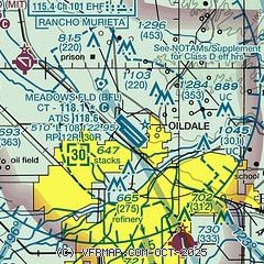
|
CAUTION: Diagram may not be current
 Download PDF
of official airport diagram from the FAA
| Airport distance calculator |
|---|
|
|
| Sunrise and sunset |
|---|
|
Times for 24-Apr-2026
| | Local
(UTC-7) | | Zulu
(UTC) |
|---|
| Morning civil twilight | | 05:47 | | 12:47 |
| Sunrise | | 06:13 | | 13:13 |
| Sunset | | 19:35 | | 02:35 |
| Evening civil twilight | | 20:02 | | 03:02 |
|
| Current date and time |
|---|
| Zulu (UTC) | 25-Apr-2026 01:36:58 |
|---|
| Local (UTC-7) | 24-Apr-2026 18:36:58 |
|---|
|
| METAR |
|---|
| KBFL | 250054Z 35006KT 10SM CLR 26/04 A2977 RMK AO2 SLP078 T02560044
|
|
| TAF |
|---|
| KBFL | 241720Z 2418/2518 VRB06KT P6SM SCT200 FM242100 33010KT P6SM SCT150 BKN200 FM250600 VRB06KT P6SM BKN200
|
|
| NOTAMs |
|---|
NOTAMs are issued by the DoD/FAA and will open in a separate window not controlled by AirNav.
|
|


