FAA INFORMATION EFFECTIVE 09 JULY 2026
Location
| FAA Identifier: | MKJ |
| Lat/Long: | 36-53-41.4560N 081-20-59.8060W
36-53.690933N 081-20.996767W
36.8948489,-81.3499461
(estimated) |
| Elevation: | 2558.2 ft. / 779.7 m (surveyed) |
| Variation: | 06W (1990) |
| From city: | 9 miles NE of central business district of the associated city
(LCTD 9 NM NE MARION.) |
| Time zone: | UTC -4 (UTC -5 during Standard Time) |
| Zip code: | 24368 |
Airport Operations
| Airport use: | Open to the public |
| Activation date: | 09/1958 |
| Control tower: | no |
| ARTCC: | ATLANTA CENTER |
| FSS: | LEESBURG FLIGHT SERVICE STATION |
| NOTAMs facility: | MKJ (NOTAM-D service available) |
| Attendance: | MON-SAT 0800-1800, ALL SUN CLOSED
CALL 276-685-9314 |
| Wind indicator: | lighted |
| Segmented circle: | yes |
| Lights: | MIRL RWY 08/26 PRESET LOW INTST; ACTVT HIGHER INTST - CTAF. |
| Beacon: | white-green (lighted land airport)
Operates sunset to sunrise. |
Airport Communications
| CTAF/UNICOM: | 122.7 |
| WX AWOS-3: | 123.875 (276-686-6420) |
- APCH/DEP SVC PRVDD BY ATLANTA ARTCC ON FREQS 127.85/269.3 (TRI CITY RCAG).
Nearby radio navigation aids
| VOR radial/distance | | VOR name | | Freq | | Var |
|---|
| BLFr200/25.8 | | BLUEFIELD VOR/DME | | 115.05 | | 03W |
| PSKr255/32.6 | | PULASKI VORTAC | | 116.80 | | 06W |
| GZGr085/35.2 | | GLADE SPRING VOR/DME | | 115.55 | | 02W |
Airport Services
| Fuel available: | 100LL JET-A+ |
| Parking: | hangars and tiedowns |
| Airframe service: | MAJOR |
| Powerplant service: | MAJOR |
| Bottled oxygen: | NONE |
| Bulk oxygen: | NONE |
Runway Information
Runway 8/26
| Dimensions: | 5252 x 75 ft. / 1601 x 23 m |
| Surface: | asphalt, in excellent condition |
| Weight bearing capacity: | |
| Runway edge lights: | medium intensity |
| RUNWAY 8 | | RUNWAY 26 |
| Latitude: | 36-53.565988N | | 36-53.815847N |
| Longitude: | 081-21.512498W | | 081-20.481012W |
| Elevation: | 2558.2 ft. | | 2502.7 ft. |
| Traffic pattern: | left | | left |
| Runway heading: | 079 magnetic, 073 true | | 259 magnetic, 253 true |
| Markings: | nonprecision, in good condition | | nonprecision, in good condition |
| Visual slope indicator: | 2-light PAPI on left (3.00 degrees glide path) | | 2-light PAPI on left (3.75 degrees glide path) |
| Runway end identifier lights: | yes | | yes |
| Touchdown point: | yes, no lights | | yes, no lights |
| Instrument approach: | | | LOC/DME |
| Obstructions: | 26 ft. trees, 612 ft. from runway, 213 ft. left of centerline, 15:1 slope to clear
8 FT BUSH 80 FT FRM THLD, 120 L OF CNTRLN ON APCH. | | 44 ft. tree, 711 ft. from runway, 321 ft. right of centerline, 11:1 slope to clear
17 FT ROADWAY CLNC PENETRATES APCH BY 9 FT. INTERSTATE TFC PENETRATES INTO PRI SFC. |
Airport Ownership and Management from official FAA records
| Ownership: | Publicly-owned |
| Owner: | SMYTH WYTHE ARPT CMSN
8223 LEE HIGHWAY
RURAL RETREAT, VA 24368
Phone 276-783-8805 |
| Manager: | BRIAN BURKETT
8223 LEE HIGHWAY
RURAL RETREAT, VA 24368
Phone 276-783-8805 |
Additional Remarks
| - | AFT HRS CTC 276-685-1122. |
| - | FOR CD CTC ATLANTA ARTCC AT 770-210-7692. |
Instrument Procedures
NOTE: All procedures below are presented as PDF files. If you need a reader for these files, you should download the free Adobe Reader.NOT FOR NAVIGATION. Please procure official charts for flight.
FAA instrument procedures published for use from 09 July 2026 at 0901Z to 06 August 2026 at 0900Z.
IAPs - Instrument Approach Procedures |
|---|
| RNAV (GPS) RWY 26 | |
download (214KB) |
| LOC RWY 26 | |
download (226KB) |
| NOTE: Special Alternate Minimums apply | |
download (75KB) |
| NOTE: Special Take-Off Minimums/Departure Procedures apply | |
download (140KB) |
Other nearby airports with instrument procedures:
KJFZ - Tazewell County Airport (24 nm NW)
KBLF - Mercer County Airport (25 nm N)
KHLX - Twin County Airport (26 nm E)
KGEV - Ashe County Airport (28 nm S)
KVJI - Virginia Highlands Airport (35 nm W)
|
|

Road maps at:
MapQuest
Bing
Google
| Aerial photo |
|---|
WARNING: Photo may not be current or correct
 Photo courtesy of AirNav, LLC
Photo taken 20-May-2012
looking south.
Photo courtesy of AirNav, LLC
Photo taken 20-May-2012
looking south.
Do you have a better or more recent aerial photo of Mountain Empire Airport that you would like to share? If so, please send us your photo.
|
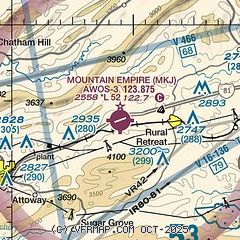
| Sectional chart |
|---|
|
| Airport distance calculator |
|---|
|
|
| Sunrise and sunset |
|---|
|
Times for 29-Jul-2026
| | Local
(UTC-4) | | Zulu
(UTC) |
|---|
| Morning civil twilight | | 06:00 | | 10:00 |
| Sunrise | | 06:29 | | 10:29 |
| Sunset | | 20:34 | | 00:34 |
| Evening civil twilight | | 21:03 | | 01:03 |
|
| Current date and time |
|---|
| Zulu (UTC) | 29-Jul-2026 23:35:58 |
|---|
| Local (UTC-4) | 29-Jul-2026 19:35:58 |
|---|
|
| METAR |
|---|
| KMKJ | 292315Z AUTO 29006KT 10SM SCT050 21/12 A2997 RMK AO2 T02110118
|
|
| TAF |
|---|
KBLF
25nm N | 291720Z 2918/3018 31009G16KT P6SM SCT040 FM300000 30003KT P6SM FEW250 FM300900 27002KT 2SM BR FEW250 FM301300 31006KT P6SM SKC
|
|
| NOTAMs |
|---|
NOTAMs are issued by the DoD/FAA and will open in a separate window not controlled by AirNav.
|
|

