FAA INFORMATION EFFECTIVE 25 DECEMBER 2025
Location
| FAA Identifier: | O05 |
| Lat/Long: | 40-16-56.5000N 121-14-28.2000W
40-16.941667N 121-14.470000W
40.2823611,-121.2411667
(estimated) |
| Elevation: | 4534.4 ft. / 1382.1 m (surveyed) |
| Variation: | 13E (2025) |
| From city: | 2 miles SW of CHESTER, CA |
| Time zone: | UTC -8 (UTC -7 during Daylight Saving Time) |
| Zip code: | 96020 |
Airport Operations
| Airport use: | Open to the public |
| Activation date: | 04/1940 |
| Control tower: | no |
| ARTCC: | OAKLAND CENTER |
| FSS: | RANCHO MURIETA FLIGHT SERVICE STATION |
| NOTAMs facility: | RIU (NOTAM-D service available) |
| Attendance: | 0800-DUSK |
| Wind indicator: | lighted |
| Segmented circle: | yes |
| Lights: | ACTVT MIRL RY 16/34 & PAPI RYS 16 & 34 - CTAF. |
| Beacon: | white-green (lighted land airport)
Operates sunset to sunrise. |
Airport Communications
| CTAF/UNICOM: | 122.8 |
| WX AWOS-3: | 118.275 (530-230-0642) |
- APCH/DEP CTL SVC PRVVD BY OAKLAND ARTCC (ZOA) ON 132.2/350.3 (RED BLUFF RCAG).
Airport Services
| Fuel available: | 100LL JET-A |
| Parking: | tiedowns |
| Airframe service: | NONE |
| Powerplant service: | NONE |
| Bottled oxygen: | NONE |
| Bulk oxygen: | NONE |
Runway Information
Runway 16/34
| Dimensions: | 5020 x 100 ft. / 1530 x 30 m |
| Surface: | asphalt, in fair condition |
| Weight bearing capacity: | | Single wheel: | 60.0, ESTIMATED BY OWNER. | | Double wheel: | 110.0 |
|
| Runway edge lights: | medium intensity |
| RUNWAY 16 | | RUNWAY 34 |
| Latitude: | 40-17.352133N | | 40-16.531320N |
| Longitude: | 121-14.534187W | | 121-14.406538W |
| Elevation: | 4534.4 ft. | | 4513.5 ft. |
| Traffic pattern: | left | | right |
| Runway heading: | 160 magnetic, 173 true | | 340 magnetic, 353 true |
| Markings: | nonprecision, in good condition | | nonprecision, in good condition |
| Visual slope indicator: | 2-light PAPI on left (3.00 degrees glide path) | | 2-light PAPI on left (3.00 degrees glide path) |
| Runway end identifier lights: | no | | no |
| Touchdown point: | yes, no lights | | yes, no lights |
| Obstructions: | 50 ft. trees, 1200 ft. from runway, 375 ft. left of centerline, 20:1 slope to clear | | 67 ft. trees, 2500 ft. from runway, 350 ft. left of centerline, 34:1 slope to clear |
Airport Ownership and Management from official FAA records
| Ownership: | Publicly-owned |
| Owner: | COUNTY OF PLUMAS
198 ANDY'S WAY
QUINCY, CA 95971-7007
Phone 530-283-6299 |
| Manager: | NICK COLLIN
198 ANDY'S WAY
QUINCY, CA 95971-7007
Phone 530-283-6069
AIRPORT FBO PHONE 530-258-3616. |
Additional Remarks
| E93 | TWO 40' DIAMETER CONC HELIPADS /USFS/ ON FLD. |
| A91 | PLUS SEVERAL FIRE BOMBERS DURING SUMMER. |
| - | FOR CD CTC OAKLAND ARTCC AT 510-745-3380. |
Instrument Procedures
NOTE: All procedures below are presented as PDF files. If you need a reader for these files, you should download the free Adobe Reader.NOT FOR NAVIGATION. Please procure official charts for flight.
FAA instrument procedures published for use from 25 December 2025 at 0901z to 22 January 2026 at 0900z.
IAPs - Instrument Approach Procedures |
|---|
| RNAV (GPS) RWY 34 | |
download (292KB) |
| NOTE: Special Alternate Minimums apply | |
download (140KB) |
|
|---|
| CHOTT ONE (OBSTACLE) (RNAV) | |
download (280KB) |
| NOTE: Special Take-Off Minimums/Departure Procedures apply | |
download (357KB) |
Other nearby airports with instrument procedures:
KSVE - Susanville Municipal Airport (31 nm E)
KCIC - Chico Regional Airport (41 nm SW)
KRBL - Red Bluff Municipal Airport (47 nm W)
O02 - Nervino Airport (49 nm SE)
KAHC - Amedee Army Airfield (50 nm E)
|
|

Road maps at:
MapQuest
Bing
Google
| Aerial photo |
|---|
WARNING: Photo may not be current or correct

Do you have a better or more recent aerial photo of Rogers Field Airport that you would like to share? If so, please send us your photo.
|
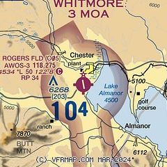
| Sectional chart |
|---|
|
| Airport distance calculator |
|---|
|
|
| Sunrise and sunset |
|---|
|
Times for 29-Dec-2025
| | Local
(UTC-8) | | Zulu
(UTC) |
|---|
| Morning civil twilight | | 06:58 | | 14:58 |
| Sunrise | | 07:28 | | 15:28 |
| Sunset | | 16:46 | | 00:46 |
| Evening civil twilight | | 17:17 | | 01:17 |
|
| Current date and time |
|---|
| Zulu (UTC) | 29-Dec-2025 12:13:39 |
|---|
| Local (UTC-8) | 29-Dec-2025 04:13:39 |
|---|
|
| METAR |
|---|
KSVE
31nm E | 291155Z AUTO 28004KT 10SM CLR M06/M07 A3055 RMK A01 P000
|
KCIC
40nm SW | 290153Z CALMKT 10SM CLR 10/03 A3028
|
KO54
47nm W | 291155Z AUTO 00000KT 1/4SM FZFG OVC002 M02/M03 A3041 RMK A01
|
KRBL
47nm W | 291154Z AUTO 33008KT 10SM CLR 07/M02 A3035 RMK AO2 SLP276 T00721017 10094 20067 58001
|
|
| TAF |
|---|
KRBL
47nm W | 291120Z 2912/3012 34008KT P6SM SKC FM300000 VRB05KT P6SM SCT200
|
|
| NOTAMs |
|---|
NOTAMs are issued by the DoD/FAA and will open in a separate window not controlled by AirNav.
|
|

